Mars Armada Resumes Contact with NASA – Ready to Rock ‘n Roll n’ Drill

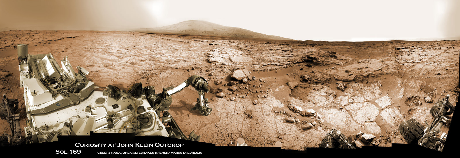
Curiosity accomplished historic 1st drilling into Martian rock at John Klein outcrop on Feb 8, 2013 (Sol 182), shown in this context mosaic view of the Yellowknife Bay basin taken on Jan. 26 (Sol 169) - back dropped with Mount Sharp - where the robot is currently working. Curiosity will bore a 2nd drill hole soon following the resumption of contact with the end of the solar conjunction period. Credit: NASA/JPL-Caltech/Ken Kremer/Marco Di Lorenzo

Curiosity accomplished historic 1st drilling into Martian rock at John Klein outcrop on Feb 8, 2013 (Sol 182), shown in this context mosaic view of the Yellowknife Bay basin taken on Jan. 26 (Sol 169) – back dropped with Mount Sharp – where the robot is currently working. Curiosity will bore a 2nd drill hole soon following the resumption of contact with the end of the solar conjunction period. Credit: NASA/JPL-Caltech/Ken Kremer/Marco Di Lorenzo
See drill hole and conjunction videos below[/caption]

After taking a well deserved and unavoidable break during April’s solar conjunction with Mars that blocked two way communication with Earth, NASA’s powerful Martian fleet of orbiters and rovers have reestablished contact and are alive and well and ready to Rock ‘n Roll ‘n Drill.

“Both orbiters and both rovers are in good health after conjunction,” said NASA JPL spokesman Guy Webster exclusively to Universe Today.

Curiosity’s Chief Scientist John Grotzinger confirmed to me today (May 1) that further drilling around the site of the initial John Klein outcrop bore hole is a top near term priority.

The goal is to search for the chemical ingredients of life.

“We’ll drill a second sample,” Grotzinger told Universe Today exclusively. Grotzinger, of the California Institute of Technology in Pasadena, Calif., leads NASA’s Curiosity Mars Science Laboratory mission.

“We’ll move a small bit, either with the arm or the wheels, and then drill another hole to confirm what we found in the John Klein hole.”

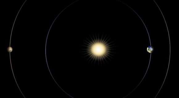
Earth, Mars and the Sun have been lined up in nearly a straight line for the past several weeks, which effectively blocked virtually all contact with NASA’s four pronged investigative Armada at the Red Planet.

NASA’s Red Planet fleet consists of the Curiosity (MSL) and Opportunity (MER) surface rovers as well as the long lived Mars Odyssey (MO) and Mars Reconnaissance Orbiter (MRO) robotic orbiters circling overhead. ESA’s Mars Express orbiter is also exploring the Red Planet.

“All have been in communications,” Webster told me today, May 1.

The NASA spacecraft are functioning normally and beginning to transmit the science data collected and stored in on board memory during the conjunction period when a commanding moratorium was in effect.

“Lots of data that had been stored on MRO during conjunction has been downlinked,” Webster confirmed to Universe Today.

Curiosity and Mount Sharp: Curiosity's elevated robotic arm and drill are staring back at you - back dropped by Mount Sharp, her ultimate destination.  The rover team anticipates new science discoveries following the resumption of contact with NASA after the end of solar conjunction.  This panoramic vista of Yellowknife Bay basin was snapped on March 23, Sol 223 prior to conjunction and assembled from several dozen raw images snapped by the rover's navigation camera system.  These images were snapped after the robot recovered from a computer glitch in late Feb and indicated she was back alive and functioning working normally. Credit: NASA/JPL-Caltech/Marco Di Lorenzo/KenKremer (kenkremer.com).
Curiosity and Mount Sharp: Curiosity’s elevated robotic arm and drill stare back at you at the John Klein drill site – back dropped by mysterious Mount Sharp. The rover has resumed contact with NASA following the end of solar conjunction. This panoramic vista was snapped on March 23, 2013, Sol 223. Credit: NASA/JPL-Caltech/Marco Di Lorenzo/KenKremer (kenkremer.com)

And NASA is already transmitting and issuing new marching orders to the Martian Armada to resume their investigations into unveiling the mysteries of the Red Planet and determine whether life ever existed eons ago or today.

“New commanding, post-conjunction has been sent to both orbiters and Opportunity.”

“And the sequence is being developed today for sending to Curiosity tonight (May 1), as scheduled more than a month ago,” Webster explained.

“We’ll spend the next few sols transitioning over to new flight software that gives the rover additional capabilities,” said Grotzinger.

“After that we’ll spend some time testing out the science instruments on the B-side rover compute element – that we booted to before conjunction.”

Curiosity is at work inside the Yellowknife Bay basin just south of the Martian equator. Opportunity is exploring the rim of Endeavour crater at the Cape York rim segment.
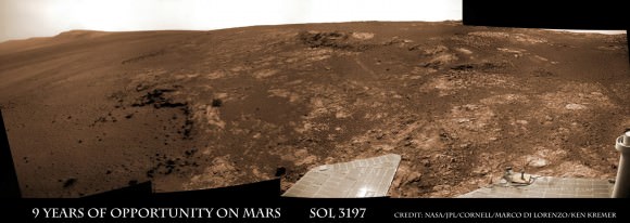
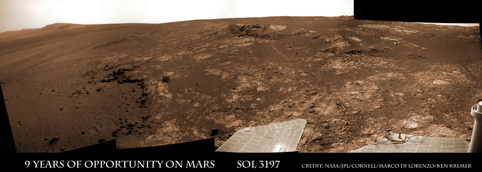
Opportunity Celebrates 9 Years and 3200 Sols on Mars snapping this panoramic view from her current location on ‘Matijevic Hill’ at Endeavour Crater. The rover discovered phyllosilicate clay minerals and calcium sulfate veins at the bright outcrops of ‘Whitewater Lake’, at right, imaged by the Navcam camera on Sol 3197 (Jan. 20, 2013). “Copper Cliff” is the dark outcrop, at top center. Darker “Kirkwood” outcrop, at left, is site of mysterious “newberries” concretions. Credit: NASA/JPL-Caltech/Cornell/Marco Di Lorenzo/Ken Kremer

Mars Solar Conjunction is a normal celestial event that occurs naturally about every 26 months. The science and engineering teams take painstaking preparatory efforts to insure no harm comes to the spacecraft during the conjunction period when they have no chance to assess or intervene in case problems arise.

So it’s great news and a huge relief to the large science and operations teams handling NASA’s Martian assets to learn that all is well.

Since the sun can disrupt and garble communications, mission controllers suspended transmissions and commands so as not to inadvertently create serious problems that could damage the fleet in a worst case scenario.

So what’s on tap for Curiosity and Opportunity in the near term ?

“For the first few days for Curiosity we will be installing a software upgrade.”

“For both rovers, the science teams will be making decisions about how much more to do at current locations before moving on,” Webster told me.

The Opportunity science team has said that the long lived robot has pretty much finished investigating the Cape York area at Endeavour crater where she made the fantastic discovery of phyllosilicates clay minerals that form in neutral water.

Signals from Opportunity received a few days ago on April 27 indicated that the robot had briefly entered a standby auto mode while collecting imagery of the sun.

NASA reported today that all operations with Opportunity was “back under ground control, executing a sequence of commands sent by the rover team”, had returned to normal and the robot exited the precautionary status.
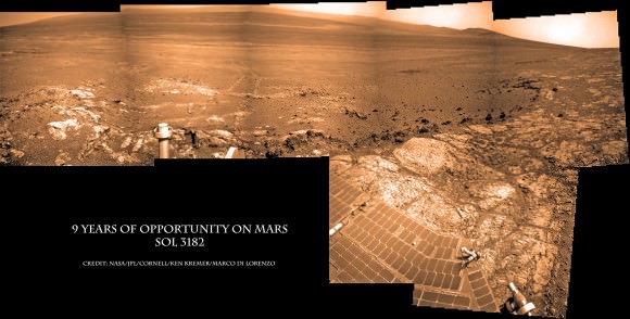
Opportunity Celebrates 9 Years on Mars snapping this panoramic view of the vast expanse of 14 mile (22 km) wide Endeavour Crater from atop ‘Matijevic Hill’ on Sol 3182 (Jan. 5, 2013). The rover then drove 43 feet to arrive at ‘Whitewater Lake’ and investigate clay minerals. Photo mosaic was stitched from Navcam images and colorized. Credit: NASA/JPL-Caltech/Cornell/Ken Kremer/Marco Di Lorenzo

“The Curiosity team has said they want to do at least one more drilling in Yellowknife Bay area,” according to Webster.

Curiosity has already accomplished her primary task and discovered a habitable zone that possesses the key ingredients needed for potential alien microbes to once have thrived in the distant past on the Red Planet when it was warmer and wetter.

The robot found widespread evidence for repeated episodes of flowing liquid water, hydrated mineral veins and phyllosilicates clay minerals on the floor of her Gale Crater landing site after analyzing the first powder ever drilled from a Martian rock.

Video Caption: Historic 1st bore hole drilled by NASA’s Curiosity Mars rover on Sol 182 of the mission (8 Feb 2013). Credit: NASA/JPL-Caltech/MSSS/Marco Di Lorenzo/Ken Kremer (http://www.kenkremer.com/)

During conjunction Curiosity collected weather, radiation and water measurements but no imagery.

Check out this wonderful new story at Space.com featuring Curiosity mosaics by me and my imaging partner Marco Di Lorenzo and an interview with me.
Ken Kremer

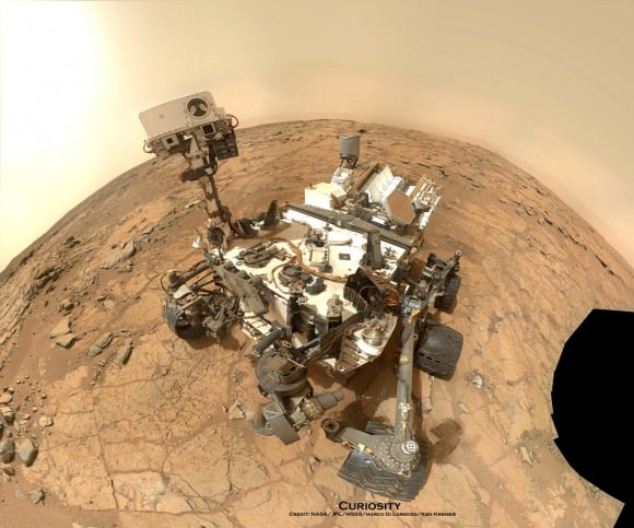
Curiosity Rover snapped this self portrait mosaic with the MAHLI camera while sitting on flat sedimentary rocks at the “John Klein” outcrop where the robot conducted historic first sample drilling inside the Yellowknife Bay basin, on Feb. 8 (Sol 182) at lower left in front of rover. The photo mosaic was stitched from raw images snapped on Sol 177, or Feb 3, 2013, by the robotic arm camera - accounting for foreground camera distortion. Credit: NASA/JPL-Caltech/MSSS/Marco Di Lorenzo/KenKremer (kenkremer.com).
Curiosity Rover snapped this self portrait mosaic with the MAHLI camera while sitting on flat sedimentary rocks at the “John Klein” outcrop where the robot conducted historic first sample drilling inside the Yellowknife Bay basin, on Feb. 8 (Sol 182) at lower left in front of rover. The photo mosaic was stitched from raw images snapped on Sol 177, or Feb 3, 2013, by the robotic arm camera – accounting for foreground camera distortion. Credit: NASA/JPL-Caltech/MSSS/Marco Di Lorenzo/KenKremer (kenkremer.com).

Watch this brief NASA JPL video for an explanation of Mars Solar Conjunction.

Terran Fleet at Mars Takes a Break for Conjunction – Enjoy the Video and Parting View

Curiosity and Mount Sharp - Parting Shot ahead of Solar Conjunction. Enjoy this parting view of Curiosity's elevated robotic arm and drill are staring at you - back dropped with her ultimate destination - Mount Sharp - in this panoramic vista of Yellowknife Bay basin snapped on March 23, Sol 223, by the rover's navigation camera system. The raw images were stitched by Marco Di Lorenzo and Ken Kremer and colorized. Credit: NASA/JPL-Caltech/Marco Di Lorenzo/KenKremer (kenkremer.com). See video below explaining Mars Solar Conjunction

Curiosity and Mount Sharp – Parting Shot ahead of Mars Solar Conjunction
Enjoy this parting view of Curiosity’s elevated robotic arm and drill staring at you; back dropped with her ultimate destination – Mount Sharp – in this panoramic vista of Yellowknife Bay basin snapped on March 23, Sol 223, by the rover’s navigation camera system. The raw images were stitched by Marco Di Lorenzo and Ken Kremer and colorized. Credit: NASA/JPL-Caltech/Marco Di Lorenzo/KenKremer (kenkremer.com)
See video below explaining Mars Solar Conjunction[/caption]

Earth’s science invasion fleet at Mars is taking a break from speaking with their handlers back on Earth.

Why ? Because as happens every 26 months, the sun has gotten directly in the way of Mars and Earth.

Earth, Mars and the Sun are lined up in nearly a straight line. The geometry is normal and it’s called ‘Mars Solar Conjunction’.

Conjunction officially started on April 4 and lasts until around May 1.

From our perspective here on Earth, Mars will be passing behind the Sun.

Watch this brief NASA JPL video for an explanation of Mars Solar Conjunction.
Therefore the Terran fleet will be on its own for the next month since the sun will be blocking nearly all communications.

In fact since the sun can disrupt and garble communications, mission controllers will be pretty much suspending transmissions and commands so as not to inadvertently create serious problems that could damage the fleet in a worst case scenario.

Right now there are a trio of orbiters and a duo of rovers from NASA and ESA exploring Mars.

The spacecraft include the Curiosity (MSL) and Opportunity (MER) rovers from NASA. Also the Mars Express orbiter from ESA and the Mars Odyssey (MO) and Mars Reconnaissance Orbiter (MRO) from NASA.

Geometry of Mars Solar Conjunction

Because several of these robotic assets have been at Mars for nearly 10 years and longer, the engineering teams have a lot of experience with handling them during the month long conjunction period.

“This is our sixth conjunction for Odyssey,” said Chris Potts of JPL, mission manager for NASA’s Mars Odyssey, which has been orbiting Mars since 2001. “We have plenty of useful experience dealing with them, though each conjunction is a little different.”

But there is something new this go round.

“The biggest difference for this 2013 conjunction is having Curiosity on Mars,” Potts said. Odyssey and the Mars Reconnaissance Orbiter relay almost all data coming from Curiosity and the Mars Exploration Rover Opportunity, as well as conducting the orbiters’ own science observations.

The rovers and orbiters can continue working and collecting science images and spectral data.

But that data will all be stored in the on board memory for a post-conjunction playback starting sometime in May.

Ken Kremer

…………….

Learn more about Curiosity’s groundbreaking discoveries and NASA missions at Ken’s upcoming lecture presentations:

April 20/21 : “Curiosity and the Search for Life on Mars – (in 3-D)”. Plus Orion, SpaceX, Antares, the Space Shuttle and more! NEAF Astronomy Forum, Suffern, NY

April 28: “Curiosity and the Search for Life on Mars – (in 3-D)”. Plus the Space Shuttle, SpaceX, Antares, Orion and more. Washington Crossing State Park, Titusville, NJ, 130 PM

Opportunity Rover Starts Year 10 on Mars with Remarkable Science Discoveries

Image caption: Opportunity Celebrates 9 Years and 3200 Sols on Mars snapping this panoramic view from her current location on ‘Matijevic Hill’ at Endeavour Crater. The rover discovered phyllosilicate clay minerals and calcium sulfate veins at the bright outcrops of ‘Whitewater Lake’, at right, imaged by the Navcam camera on Sol 3197 (Jan. 20, 2013). “Copper Cliff” is the dark outcrop, at top center. Darker “Kirkwood” outcrop, at left, is site of mysterious “newberries” concretions. Credit: NASA/JPL-Caltech/Cornell/Marco Di Lorenzo/Ken Kremer

9 Years ago, NASA’s pair of identical twin sister rovers – christened Spirit & Opportunity- bounced to daunting airbag-cushioned landings on opposite sides of the Red Planet for what was supposed to be merely 90 day missions, or maybe a little bit longer scientists hoped.

Today, Opportunity celebrates a truly unfathomable achievement, starting Year 10 on Mars since she rolled to a bumpy stop on January 24, 2004 inside tiny Eagle crater. And she’s now at a super sweet spot for science (see our photo mosaic above) loaded with clays and veined minerals and making the most remarkable findings yet about the planets watery past – thus building upon a long string of previously unthinkable discoveries due to her totally unforeseen longevity.

“Regarding achieving nine years, I never thought we’d achieve nine months!” Principal Investigator Prof. Steve Squyres of Cornell University told Universe Today for this article commemorating Opportunity’s 9th anniversary.

Opportunity reached 3200 Sols, or Martian days, and counting , by her 9th birthday. She is now 108 months into the 3 month primary mission – that’s 36 times longer than the 3 month “warranty.”

“Every sol is a gift,” Squyres told me. He always refers to the rovers as our “Priceless assets on Mars”, that have to be taken good care of to wring out the maximum science data possible and for as long as humanly, or more aptly, robotically possible.

PIA16703_Sol3137B_Matijevic_Pan_L257atc_br2

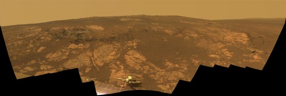
Image Caption: ‘Matijevic Hill’ Panorama for Rover’s Ninth Anniversary. As Opportunity neared the ninth anniversary of its landing on Mars, the rover was working in the ‘Matijevic Hill’ area seen in this view from Opportunity’s panoramic camera (Pancam). Two of the features investigated at Matijevic Hill are “Copper Cliff,” the dark outcrop in the left center of the image, and “Whitewater Lake,” the bright outcrop on the far right. The component images for this mosaic were taken from Sol 3137 (Nov. 19, 2012) through Sol 3150 (Dec. 3, 2012). Credit: NASA/JPL-Caltech/Cornell/Arizona State Univ.

The resilient, solar powered Opportunity robot begins her 10th year roving around beautifully Earth-like Martian terrain where where she proved that potentially life sustaining liquid water once flowed billions of years ago when the planet was warmer and wetter.

Opportunity is healthy and has driven over 22 miles (35 kilometers )- marking the first overland expedition on another planet. See our photo mosaics and route map by Ken Kremer and Marco Di Lorenzo.

She is now working at the inboard edge of “Cape York” – a hilly segment of the eroded rim of 14 mile (22 km) wide Endeavour Crater, featuring terrain with older rocks than previously inspected and unlike anything studied before. It’s a place no one ever dared dream of reaching prior to launch in the summer of 2003 and landing on the Meridiani Planum region of Mars.

“It’s like a whole new mission since we arrived at Cape York,” says Squyres.

Opportunity Sol 3182_3Ba_Ken Kremer

Image caption: Opportunity Celebrates 9 Years on Mars snapping this panoramic view of the vast expanse of 14 mile (22 km) wide Endeavour Crater from atop ‘Matijevic Hill’ on Sol 3182 (Jan. 5, 2013). The rover then drove 43 feet to arrive at ‘Whitewater Lake’ and investigate clay minerals. Photo mosaic was stitched from Navcam images and colorized. Credit: NASA/JPL-Caltech/Cornell/Ken Kremer/Marco Di Lorenzo

Today Opportunity is poised for breakthrough science at deposits of phyllosilicates – clay minerals which stem from an earlier epoch when liquid water flowed on Mars eons ago and perhaps may have been more favorable to sustaining microbial life because they form in more neutral pH water. Endeavour Crater is more than 3 Billion years old.

I asked Squyres to discuss the discovery of the phyllosilicates – which have never before been analyzed up close on the Martian surface and are actually a main target of NASA’s new Curiosity rover at Gale Crater.

“We have found the phyllosilicates at Cape York: they’re in the Whitewater Lake materials,” Squyres explained. Spectral data collected from Mars orbit by the CRISM spectrometer aboard NASA’s MRO circling spacecraft allowed the researchers to direct Opportunity to this exact spot.

“Whitewater Lake” is an area of bright local outcrops currently being investigated and providing information about a different and apparently less acidic environment compared to other areas and craters visited earlier in the mission – and potentially more conducive to life.

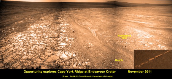
Opportunity also discovered more mineral veins at “Whitewater Lake”, in addition to those hydrated mineral veins discovered earlier at Cape York at a spot named “Homestake” – see our mosaic below.

“We have investigated the veins in these materials, and we have determined that they are calcium sulfate,” Squyres confirmed to me.

Opportunity Sol 2761_2a_Ken Kremer

Image caption: Opportunity discovers hydrated Mineral Vein at Endeavour Crater – November 2011. Opportunity determined that the ‘Homestake’ mineral vein was composed of calcium sulfate,or gypsum, while exploring around the base of Cape York ridge at the western rim of Endeavour Crater. The vein discovery indicates the ancient flow of liquid water at this spot on Mars. This panoramic mosaic of images was taken on Sol 2761, November 2011, and illustrates the exact spot of the mineral vein discovery. Featured on NASA Astronomy Picture of the Day (APOD) on 12 Dec 2011. Credit: NASA/JPL/Cornell/Kenneth Kremer/Marco Di Lorenzo.

How do the new mineral veins compare to those at ‘Homestake’ and those just found by Curiosity at Yellowknife Bay inside Gale crater? I asked Sqyures.

“Much narrower, and possibly older,” he said compared to the Homestake calcium sulfate veins .

“It’s too early to say how they compare to the veins at Gale, though.”

The local area at “Cape York” is called “Matijevic Hill” – in honor of a recently deceased team member who played a key role on NASA’s Mars rovers.

The rover has already spent a few months at “Matijevic Hill” on a ‘walk about’ scouting survey and also found concretions dubbed “newberries” that are different from the “blueberry” concretions found earlier in the mission.

How widespread are the phyllosilicates ?

“Matijevic Hill is the only exposure of phyllosilicates we know of at Cape York, so in order to find more we’re going to have to go elsewhere,” Squyres replied. “We haven’t figured out what the “newberries” are yet, but attempting to do that will be our next task.”

It is likely to take many more weeks and even months to “figure out” what this all means for science.

Therefore, no one should expect the robot to move much in the near future. Since the rover made landfall at the western rim of Endeavour crater at Spirit Point in August 2011, she has been circling around Cape York ever since.

Opportunity Sol 2678c_Ken Kremer

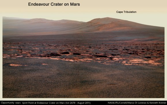
Image caption: Opportunity rover first arrived at the western rim of Endeavour Crater (14 miles, 22 km wide) in August 2011. This photo mosaic of navcam images shows portions of the segmented rim of Endeavour crater on Sol 2678. Large ejecta blocks from a smaller nearby crater are visible in the middle. At Endeavour, Opportunity will investigate the oldest minerals deposits she has ever visited from billions of years ago and which may hold clues to environments that were potentially habitable for microbial life. The rover may eventually drive to Cape Tribulation at right if she survives. Credit: NASA/JPL/Cornell/Marco Di Lorenzo/Ken Kremer (kenkremer.com)

What is the next destination for Opportunity?

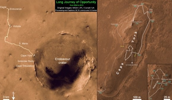
“Once we’re done at Cape York, our next destination will be Solander Point [to the south],” Squyres confirmed. It’s the next rim segment south of Cape York (see map).

Eventually, if Opportunity continues to function and survives the next Martian winter, she may be directed several miles even further south, along the crater rim to a spot called Cape Tribulation – because it also harbors caches of phyllosilicate clay minerals. But there is no telling when that might be.

“One step at a time,” said Squyres as always. He is not making any guesses or predictions. The mission is totally discovery driven.

Well after so many great science discoveries over the past 9 years, I asked Squyres to describe the context and significance of the phyllosilicates discovery?

“Impossible to say, I’m afraid… we’re still figuring this place out; I can’t put it in context yet,” Squyres concluded.

Thus, there is still so much more bountiful science research still to be done by Opportunity – and nobody is making any forecasts on how long she might yet survive.

So just keep praying to the Martian weather gods for occasional winds and “dust devils” to clean off those life giving solar panels – and to the US Congress to provide the essential funding.

Ken Kremer

Opportunity Sol 2852a_Ken Kremer

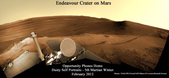
Image caption: Opportunity Phones Home – Dusty Self Portrait from Endeavour Crater on Mars on Sol 2852, February 2012. NASA’s rover Opportunity snaps self-portrait where she endured 5th frigid Martian winter at Greeley Haven. Opportunity is currently investigating Cape York ridge and Matijevic Hill at right. Vast expanse of Endeavour Crater and rim in background with dusty solar panels and full on view of the High Gain Antenna (HGA) in the foreground. Mosaic: NASA/JPL/Cornell/ASU/Marco Di Lorenzo/Ken Kremer

Opportunity Sol 2681a_annotated_Ken Kremer

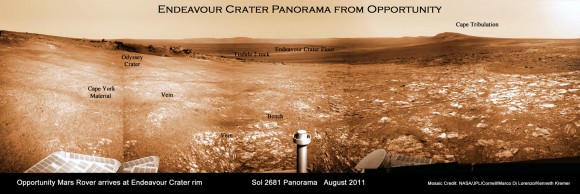
Image caption: Endeavour Crater Panorama from Opportunity, Sol 2681, August 2011 on arrival at the rim of Endeavour and Cape York ridge. Odyssey crater visible at left. Mineral veins were later found to surround Cape York. Credit: NASA/JPL/Cornell/Marco Di Lorenzo/Ken Kremer

Opportunity Route map_3187s_Ken Kremer

Image caption: Traverse Map for NASA’s Opportunity rover from 2004 to 2013 – shows the entire path the rover has driven over 9 years, 3200 Sols and more than 22 miles (35 km) from Eagle Crater landing site to current location at Cape York ridge at Endeavour Crater. Credit: NASA/JPL/Cornell/ASU/Marco Di Lorenzo/Ken Kremer (kenkremer.com)

Weekly Space Hangout – January 25, 2013

Back by popular demand… the Weekly Space Hangout has returned. This is a weekly broadcast on Google+, where I’m joined by a wide and varied team of space and astronomy journalists to discuss the big breaking stories this week.

This week, we talked about:

We record the Weekly Space Hangout every Friday on Google+ at 12:00 pm PST / 3:00 pm EST / 2000 GMT. You’ll want to circle Cosmoquest on Google+ to find out when we’re recording next. The audio for the Weekly Space Hangout is also released to the Astronomy Cast podcast feed.

Rover Team Chooses 1st Rock Drilling Target for Curiosity

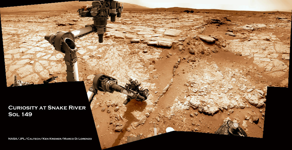
Image caption: Time lapse mosaic shows Curiosity rover’s arm movement from raised position to surface deployment on Sol 149 (Jan. 5) for contact science near the lower point of the slithery chain of narrow protruding rocks known as ‘Snake River’ – located inside the basin called “Yellowknife Bay’. The rover team will soon conduct historic first rock drilling in these surroindings. Curiosity has now driven to the larger, broken rock just above, right of the sinuous ‘Snake River’ rock formation. Photomosaic was stitched from Navcam raw images and is colorized with patches of sky added to fill in image gaps. Credit: NASA/JPL-Caltech/Ken Kremer/Marco Di Lorenzo

A team of Mars scientists and engineers have chosen the 1st rock drilling target for NASA’s Curiosity rover after carefully considering a range of options over the past several weeks at the robots current location inside a shallow depression known as ‘Yellowknife Bay’, which is replete with light toned rocks.

An official NASA announcement with further information is forthcoming on Tuesday this week, according to a source for this report.

Curiosity is now conducting a detailed science evaluation of the vicinity around a slithery chain of rocks called ‘Snake River’, jutting up from the sandy, rock strewn Martian floor – see our illustrative photo mosaics above & below and earlier story here.

Drilling goes to the heart of the mission and will mark a historic feat in planetary exploration – as the first time that an indigenous sample has been cored from the interior of a rock on another planet and subsequently analyzed by chemical spectrometers to determine its elemental composition and determine if organic molecules are present.

The first report of the drill target selection came just a day ago from Craig Covault at NASA Watch/Spaceref in an article, here – featuring our ‘Snake River’ time lapse mosaic (by Ken Kremer and Marco Di Lorenzo). The mosaic shows the arm in action deploying its science instruments and rotating to capture pictures with the MAHLI microscopic imager and contact science with the APXS mineral spectrometer.

The exact drilling spot has not been divulged but is likely near ‘Snake River’ and visible in our mosaics from Sol 149 and earlier Sols inside the ‘Yellowknife Bay’ basin – which exhibits cross bedding and is reminiscent of a dried up shoreline. Curiosity has now driven to the larger, broken rock just above, right of the sinuous ‘Snake River’ rock formation for up-close contact science investigations.

Curiosity 1st brushoff sol 150_1a_Ken Kremer

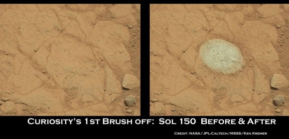
Image Caption: Before and after comparison of images of 1st ever rock brush off by Curiosity’s Dust Removal Tool (DRT) on Sol 150 (Jan 6, 2013), nearby to Snake River. Images taken by the high resolution Mastcam 100 camera, contrast enhanced. The brushed patch of rock target called “Ekwir_1” ‘is about 1.85 inches by 2.44 inches (47 millimeters by 62 millimeters). Credit: NASA/JPL-Caltech/MSSS/Ken Kremer

The Mars Science Lab (MSL) team is coordinating with top JPL & NASA management to get approval for the drilling location chosen or select another rock.

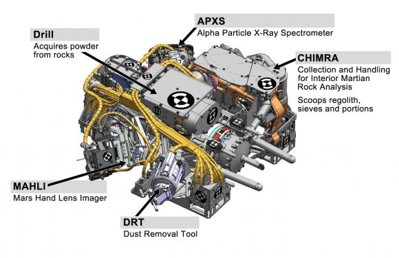
The high powered hammering drill is located on the tool turret at the end of the car-sized robots 7 foot (2.1 meter) long mechanical arm.

The percussive drill is the last component of Curiosity’s ten state-of-the-art science instruments that remains to be checked out and put into action.

Rock samples collected from the first test bore holes will be pulverized and the powdery mix will initially be used to rinse the interior chambers of the drill mechanisms and cleanse out residual earthly contaminants – and then dumped. The same procedure was carried out at the windblown ‘Rocknest’ ripple with the initial scoops of soil to cleanse the CHIMRA sample processing systems.

So it’s likely to take several weeks and possible a month or more until sieved samples are finally delivered to the CheMin and SAM analytical chemistry labs on the rover deck for analysis of their inorganic and organic chemical composition.

Curiosity touches Yellowknife Bay Sol 132_4c_Ken Kremer

Image caption: Photo mosaic shows NASA’s Curiosity Mars rover reaching out to investigate rocks at a spot inside Yellowknife Bay on Sol 132, Dec 19, 2012. In search of first drilling target the rover drove to a spot at the right edge of this mosaic called Snake River rock. Curiosity’s navigation camera captured the scene surrounding the rover with the arm deployed and the APXS and MAHLI science instruments on tool turret collecting imaging and X-ray spectroscopic data. Base of Mount Sharp visible at right. The mosaic is colorized with patches of sky added to fill in gaps. Click to enlarge. Credit: NASA/JPL-Caltech/Ken Kremer/Marco Di Lorenzo

As a prelude on Sol 150 (Jan 6.), the rover successfully brushed off one of the flat rocks around Snake River for the first time by using the motorized, wire-bristle brush on the Dust Removal Tool (DRT), built by Honeybee Robotics of NYC.

The brushing was completed on a rock target called ‘Ekwir_1’ – see our mosaic showing a before and after comparison of rock surface images snapped by the Mastcam-100 high resolution color camera.

Brushing is a key step prior to rock drilling and allows the team to much more easily gain insight into the rocks composition with the science instruments compared to the obscured view of a dust blanketed rock. Spirit & Opportunity also have Honeybee Robotics built brushes that have still endured throughout their years’ long miraculous lifetimes.

The team then commanded the rover to bump a bit closer to “slightly younger rocks in front of the rover,” says MSL team member Ken Herkenhoff.

“The contact science activities in the current location went well, including the first brushing of the surface. In order to characterize the geology and chemistry of the rocks at the edge of Yellowknife Bay, we intend to repeat the set of brushing, APXS, MAHLI, ChemCam and Mastcam activities at the new location starting on Sol 152.”

“We are studying chemical and textural differences in the rocks near Snake River,” says Herkenhoff.

On Sol 152 (Jan. 8), Curiosity drove 2.5 meters closer to the area surrounding ‘Snake River’ and began snapping high resolution color imagery.

“It’s one piece of the puzzle,” says John Grotzinger, the mission’s chief scientist of the California Institute of Technology. “It has a crosscutting relationship to the surrounding rock and appears to have formed after the deposition of the layer that it transects.”

Grotzinger and the team are excited because Curiosity is a sort of time machine providing a glimpse into the Red Planets ancient history when the environment was warmer and wetter billions of years ago and much more conducive to the origin of life.

Ken Kremer

PIA16145

Image caption: Diagram shows all instruments on Tool turret on robotic arm. Credit: NASA

Opportunity Rover Glimpses Conditions Suitable for Life

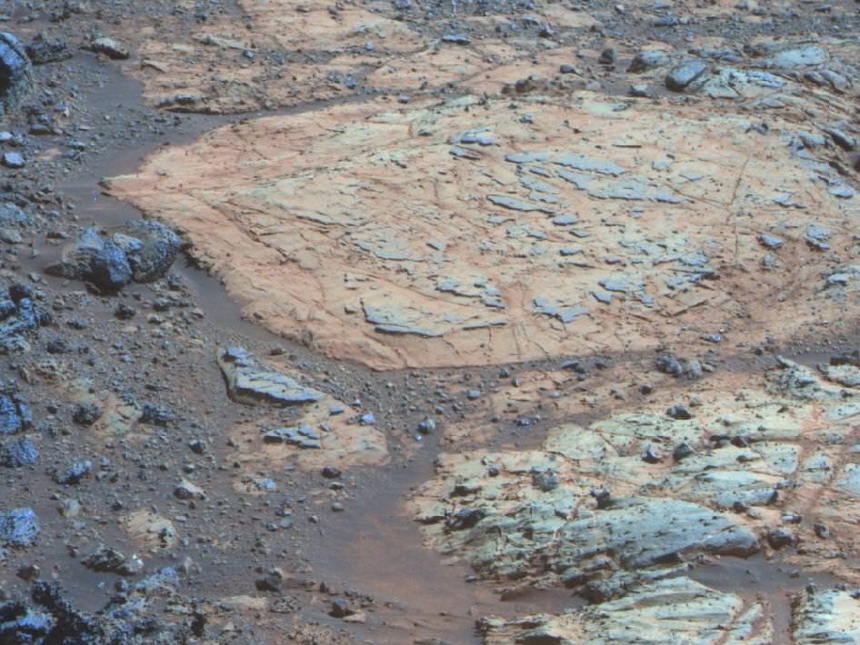
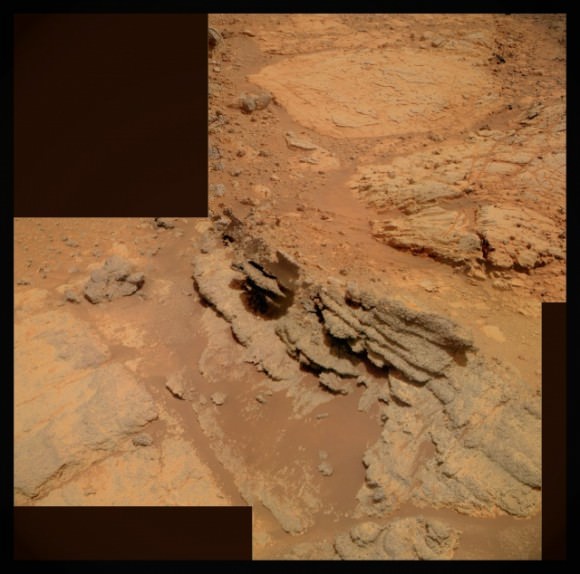
Whitewater Lake is the large flat rock in the top half of the image. From left to right it is about 30 inches (0.8 meter) across. The dark blue nubby rock to the lower left is “Kirkwood,” which bears non-hematite spherules. Credit: NASA/JPL-Caltech/ Cornell Univ./Arizona State Univ.

Steve Squyres, Principal Investigator for the Mars Explorations Rovers, cracked open the equivalent of the Opportunity rover’s field geologist’s notebook to describe what he called “a delightful geological puzzle.”

“This is a work in progress,” Squyres said at the American Geophsical Union conference today, “But this is our first glimpse ever at conditions on ancient Mars that clearly show us a chemistry that would have been suitable for life.”

While both the MER rovers have found evidence of past water on Mars, all indications are that it would have been very acidic, with “battery-acid kind of numbers making it very challenging for life,” Squyres said.

Newly found clays that are sprinkled with two different kinds of previously unseen features point to a different type of water “that you could drink,” Sqyures added.

Orbital data from the Mars Reconnaissance Orbiter’s CRISM (Compact Reconnaissance Imaging Spectrometer for Mars) instrument originally led the MER team to Endeavour Crater, the huge crater where Opportunity is now traversing around the rim.

“It was discovered from CRISM that there were clay minerals there,” Squyres said, “and clays form in a watery environment, and only form under a neutral pH, water that is not acidic.”

The rover has found a region filled with light-toned rocks, such as the Whitewater Lake rock, above, around a small hill named “Matijevic Hill” in the “Cape York” segment of the rim of Endeavour Crater. Squyres described it as the “sweet spot” where clays are known to be present.

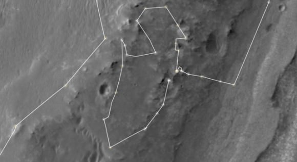
This map shows the route driven by NASA’s Mars Exploration Rover Opportunity during a reconnaissance circuit around an area of interest called “Matijevic Hill” on the rim of a large crater. Image credit: NASA/JPL-Caltech/University of Arizona

They have since driven the rover around Matijevic Hill to survey the clays, “which is what you would do if you were a geologist at a site, you’d walk the outcrop,” Squyres said. “We’ve got a good map of where the good, interesting stuff is at Matijevic Hill.”

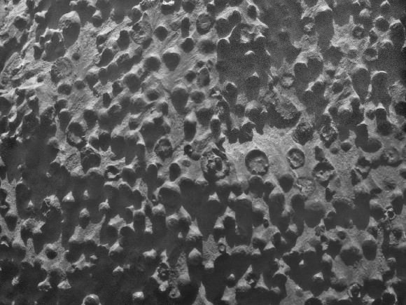
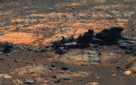
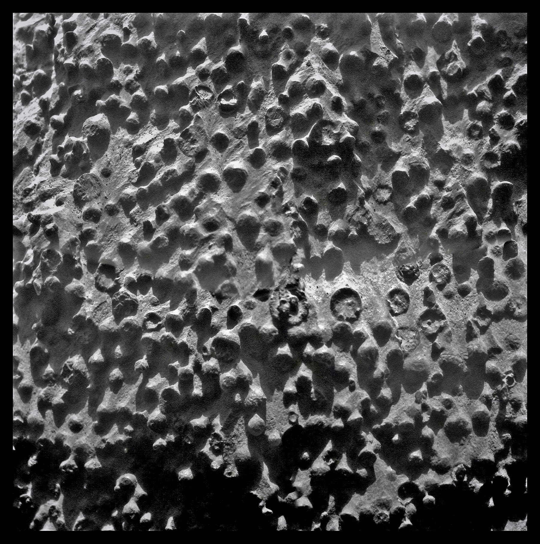
Interspersed on the light-toned rocks are fine veins of even lighter material, which has never been seen before. Additionally, there are “fins” of darker rock sticking up in the region, and within the fins are dense concentrations of spherical little features, about 3 mm in size that are very similar to the hematite Martian “blueberries” that Opportunity has seen before. But when they looked at the chemical composition of these spheres, the science team found they weren’t blueberries, because they contained no iron, which is what hematite is made from.

“It’s something totally different, and I’ve started calling them ‘newberries’,” said Squyres.

Small spherical objects fill the field in this mosaic combining four images from the Microscopic Imager on NASA’s Mars Exploration Rover Opportunity. Image credit: NASA/JPL-Caltech/Cornell Univ./ USGS/Modesto Junior College

It is difficult for the rover to determine the chemical make-up of the newberries and the light-colored veins because they are such small features, the rover can’t focus merely on those features. But Squyres and team have come up with a to-do list to try and figure out the mystery of the clays and newberries:

Task one is to understand the Whitewater Lake rock better and look at the rock’s sediments, to understand the layers in the rock: were the layers laid down by water, impact or another process?

The second task is to figure out what the newberries made of. They will have to observe regions that have different concentrations of the spherules to eke out what minerals are and aren’t part of the newberries.

Task three is to find a “contact place” where the light-toned clay rocks like Whitewater are touching the breccias – the broken and fused rock born of the impact that created the crater – that is present all around the rim of Endeavour. They haven’t yet found a place where the two are together.

Task four is to figure out what the fine veins are in the clay rocks.

The tasks are intertwined, Squyres said. “Figuring out the newberries will be important for figuring out the how these clays were laid down. So the stories aren’t independent, they are woven together and we still have homework to do,” he said.

But the team will have to work fast.

Opportunity image of light, flat rocks containing clay and mysterious darker rocks jutting through them. NASA/JPL-Caltech/ Cornell Univ./Arizona State Univ

They have about 6 months before winter sets in again in Meridiani Planum on Mars.

“We’ll soon start doing some serious winter planning,” said Diana Blaney, Deputy Project Scientist. When asked about the potential for Oppy to make it through another winter, Blaney said it all depends on the amount of dust build-up on the solar panels and how much power can be generated. “We don’t have any reason not to expect to survive, but it is a dynamic situation, and are looking ahead to find potential wintering sites,” that have beneficial tilt for the rover to absorb as much sunlight as possible.

The last winter the Opportunity rover endured was the first time the rover had to remain stationary due to power concerns because of dust accumulation on the solar arrays.

“We’re nine years into a 90 day mission,” Squyres said, “and every day is a gift at this point and we’re just going to keep pushing ourselves and the rover.”

A 3-D mosaic of the Cape York region where Opportunity is now working. Credit: NASA/JPL-Caltech/ Cornell Univ./Arizona State Univ

For additional information, see this NASA press release.

Mars Dust Storm Likely Not Going Global

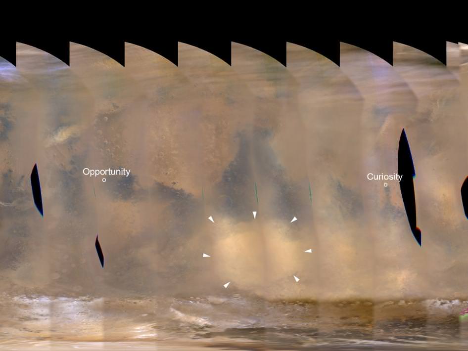
A regional dust storm visible in the southern hemisphere of Mars in this nearly global mosaic of observations made by the Mars Color Imager on NASA’s Mars Reconnaissance Orbiter on Nov. 25, 2012, has contracted from its size a week earlier. Image credit: NASA/JPL-Caltech/MSSS

Good news for the spacecraft sitting on or orbiting Mars: a dust storm on the Red Planet that looked as though it could spread around the entire planet now appears to be abating rather than going global, NASA says.

“During the past week, the regional storm weakened and contracted significantly,” said Bruce Cantor of Malin Space Science Systems, San Diego. Cantor uses the Mars Color Imager camera on NASA’s Mars Reconnaissance Orbiter to monitor storms on the Red Planet.

Recent images and data from the Environmental Monitoring Station (REMS) on the Curiosity rover have also shown a hazy atmosphere and air pressure changes in the vicinity of Gale Crater.

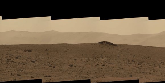
Part of gigantic panorama from Curiosity, showing an increasingly hazy view off in the distance, likely because of a dust storm. Credit: NASA/JPL/MSS, with image editing by Stuart Atkinson. See the full panorama here.

“We are getting lots of good data about this storm,” said Mark Richardson of Ashima Research, Pasadena, California, a co-investigator both on REMS and on the Mars Reconnaissance Orbiter’s Mars Climate Sounder instrument, which has been detecting widespread effects of the current storm on atmospheric temperatures.

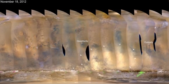
Here’s a look at the growing dust storm from the Mars Color Imager on NASA’s Mars Reconnaissance Orbiter on Nov. 18, 2012 to compare with the lead image:

Credit:NASA/JPL-Caltech/MSSS

Researchers anticipate that the unprecedented combination of a near-equatorial weather station at ground level, and daily orbital observations during Mars’ dust-storm season, may provide information about why some dust storms grow larger than others.

This is good information to have for any potential future human visitors to Mars.

Source: JPL

Can Humans Live on Mars?

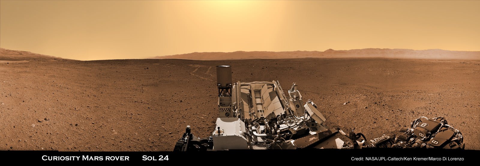
Image caption: Curiosity is taking the first ever radiation measurements from the surface of another planet in order to determine if future human explorers can live on Mars – as she traverses the terrain of the Red Planet. Curiosity is looking back to her rover tracks and the foothills of Mount Sharp and the eroded rim of Gale Crater in the distant horizon on Sol 24 (Aug. 30, 2012). This panorama is featured on PBS NOVA ‘Ultimate Mars Challenge’ documentary which premiered on PBS TV on Nov. 14. RAD is located on the rover deck in this colorized mosaic stitched together from Navcam images by the image processing team of Ken Kremer & Marco Di Lorenzo. Credit: NASA / JPL-Caltech / Ken Kremer / Marco Di Lorenzo

Metallic robots constructed by ingenious humans can survive on Mars. But what about future human astronauts?

NASA’s plucky Mars Exploration Rover Opportunity has thrived for nearly a decade traversing the plains of Meridiani Planum despite the continuous bombardment of sterilizing cosmic and solar radiation from charged particles thanks to her radiation hardened innards.

How about humans? What fate awaits them on a bold and likely year’s long expedition to the endlessly extreme and drastically harsh environment on the surface of the radiation drenched Red Planet – if one ever gets off the ground here on Earth? How much shielding would people need?

Answering these questions is one of the key quests ahead for NASA’s SUV sized Curiosity Mars rover – now 100 Sols, or Martian days, into her 2 year long primary mission phase.

Preliminary data looks promising.

Curiosity survived the 8 month interplanetary journey and the unprecedented sky crane rocket powered descent maneuver to touch down safely inside Gale Crater beside the towering layered foothills of 3 mi. (5.5 km) high Mount Sharp on Aug. 6, 2012.

Now she is tasked with assessing whether Mars and Gale Crater ever offered a habitable environment for microbial life forms – past or present. Characterizing the naturally occurring radiation levels stemming from galactic cosmic rays and the sun will address the habitability question for both microbes and astronauts. Radiation can destroy near-surface organic molecules.

Researchers are using Curiosity’s state-of-the-art Radiation Assessment Detector (RAD) instrument to monitor high-energy radiation on a daily basis and help determine the potential for real life health risks posed to future human explorers on the Martian surface.

“The atmosphere provides a level of shielding, and so charged-particle radiation is less when the atmosphere is thicker,” said RAD Principal Investigator Don Hassler of the Southwest Research Institute in Boulder, Colo. See the data graphs herein.

“Absolutely, the astronauts can live in this environment. It’s not so different from what astronauts might experience on the International Space Station. The real question is if you add up the total contribution to the astronaut’s total dose on a Mars mission can you stay within your career limits as you accumulate those numbers. Over time we will get those numbers,” Hassler explained.

The initial RAD data from the first two months on the surface was revealed at a media briefing for reporters on Thursday, Nov. 15 and shows that radiation is somewhat lower on Mars surface compared to the space environment due to shielding from the thin Martian atmosphere.

Image caption: Longer-Term Radiation Variations at Gale Crater. This graphic shows the variation of radiation dose measured by the Radiation Assessment Detector on NASA’s Curiosity rover over about 50 sols, or Martian days, on Mars. (On Earth, Sol 10 was Sept. 15 and Sol 60 was Oct. 6, 2012.) The dose rate of charged particles was measured using silicon detectors and is shown in black. The total dose rate (from both charged particles and neutral particles) was measured using a plastic scintillator and is shown in red. Credit: NASA/JPL-Caltech/ SwRI

RAD hasn’t detected any large solar flares yet from the surface. “That will be very important,” said Hassler.

“If there was a massive solar flare that could have an acute effect which could cause vomiting and potentially jeopardize the mission of a spacesuited astronaut.”

“Overall, Mars’ atmosphere reduces the radiation dose compared to what we saw during the cruise to Mars by a factor of about two.”

RAD was operating and already taking radiation measurements during the spacecraft’s interplanetary cruise to compare with the new data points now being collected on the floor of Gale Crater.

Mars atmospheric pressure is a bit less than 1% of Earth’s. It varies somewhat in relation to atmospheric cycles dependent on temperature and the freeze-thaw cycle of the polar ice caps and the resulting daily thermal tides.

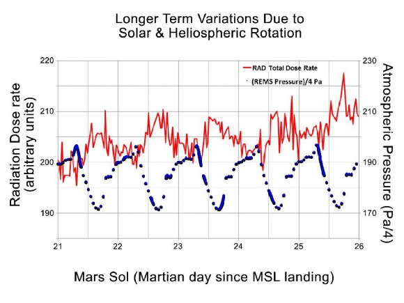
“We see a daily variation in the radiation dose measured on the surface which is anti-correlated with the pressure of the atmosphere. Mars atmosphere is acting as a shield for the radiation. As the atmosphere gets thicker that provides more of a shield. Therefore we see a dip in the radiation dose by about 3 to 5%, every day,” said Hassler.

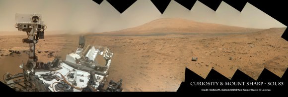
Image Caption: Curiosity Self Portrait with Mount Sharp at Rocknest ripple in Gale Crater. Curiosity used the Mars Hand Lens Imager (MAHLI) camera on the robotic arm to image herself and her target destination Mount Sharp in the background. Mountains in the background to the left are the northern wall of Gale Crater. This color panoramic mosaic was assembled from raw images snapped on Sol 85 (Nov. 1, 2012). Credit: NASA/JPL-Caltech/MSSS/Ken Kremer/Marco Di Lorenzo

There are also seasonal changes in radiation levels as Mars moves through space.

The RAD team is still refining the radiation data points.

“There’s calibrations and characterizations that we’re finalizing to get those numbers precise. We’re working on that. And we’re hoping to release that at the AGU [American Geophysical Union] meeting in December.”

Image caption: Daily Cycles of Radiation and Pressure at Gale Crater. This graphic shows the daily variations in Martian radiation and atmospheric pressure as measured by NASA’s Curiosity rover. As pressure increases, the total radiation dose decreases. When the atmosphere is thicker, it provides a better barrier with more effective shielding for radiation from outside of Mars. At each of the pressure maximums, the radiation level drops between 3 to 5 percent. The radiation level goes up at the end of the graph due to a longer-term trend that scientists are still studying. Credit: NASA/JPL-Caltech/SwRI

Radiation is a life limiting factor to habitability. RAD is the first science instrument to directly measure radiation from the surface of a planet other than Earth.

“Curiosity is finding that the radiation environment on Mars is sensitive to Mars weather and climate,” Hassler concluded.

Unlike Earth, Mars lost its magnetic field some 3.5 billion years ago – and therefore most of its shielding capability from harsh levels of energetic particle radiation from space.

Much more data will need to be collected by RAD before any final conclusions on living on Mars, and for how long and in which type habitats, can be drawn.

Learn more about Curiosity and NASA missions at my upcoming free public presentations:

And be sure to watch the excellent PBS NOVA Mars documentary – ‘Ultimate Mars Challenge’ – which also features Curiosity mosaics created by the imaging team of Ken Kremer & Marco Di Lorenzo.

Ken Kremer

…..

Dec 6: Free Public lecture titled “Atlantis, The Premature End of America’s Shuttle Program and What’s Beyond for NASA” including Curiosity, Orion, SpaceX and more by Ken Kremer at Brookdale Community College/Monmouth Museum and STAR Astronomy club in Lincroft, NJ at 8 PM

Dec 11: Free Public lecture titled “Curiosity and the Search for Life on Mars (in 3 D)” and more by Ken Kremer at Princeton University and the Amateur Astronomers Association of Princeton (AAAP) in Princeton, NJ at 8 PM.

Opportunity Rover Finds Intriguing New Spherules at Cape York

Mosaic image of the spherules in the rock outcrop on Cape York at Endeavour crater. Credit: NASA / JPL-Caltech / Stuart Atkinson

One of the most interesting discoveries made so far by the Opportunity rover on Mars has been the small round spherules or “blueberries” as they are commonly referred to, covering the ground at the rover’s landing site. Typically only a few millimetres across, some lie loose on the soil while others are imbedded in rock outcrops.

Analysis by Opportunity indicates that they are most likely a type of concretion, which are also found on Earth. These Martian concretions have been found to contain the mineral hematite, which explains its detection in this region from orbit, and one of the main reasons that the rover was sent to this location in Meridiani Planum in the first place. They are similar to the Moqui Marbles, iron-oxide concretions in the outcrops of Navajo Sanstone in Utah, which formed in groundwater.

Now, the rover (eight years later and still going!) has found what may be a different type of spherule. These ones generally resemble the previous ones, but are quite densely packed in an unusual rock outcrop that is on the eastern side of Cape York, the small island-like ledge on the rim of the huge Endeavour crater. With brittle-looking “fins” of material, the outcrop is an an area that from orbit has been identified as containing small clay deposits. There are also more substantial clay deposits farther south along Endeavour’s rim at the much larger Cape Tribulation, the next major destination of Opportunity.

Whether this outcrop actually has any clay in it isn’t known yet, but the examination of it by Opportunity continues at the time of this writing. Some spherules have apparently broken off the outcrop, exposing their inside structure. The new close-up images of the spherules were taken by the Microscopic Imager (MI) on the rover.

A portion of the rock outcrop. Credit: NASA / JPL-Caltech / Stuart Atkinson

What makes these spherules of interest is the possibility that they may be connected somehow to the clay deposits. Their dense concentration in the outcrop and the physical nature of the outcrop itself may indicate a different origin than the other spherules seen previously, as well as the fact that no hematite signature has been seen from orbit in this specific area (although there may be smaller amounts of hematite here as well). We will just have to wait for the results of the rover’s analysis to come back, but they should be interesting.

Opportunity is specifically looking for the clay deposits in this area, as they could have formed in non-acidic (or pH neutral) water as often happens on Earth. As we have seen in just the last few days though, the origin of Martian clays is itself still a subject of debate.

The whitish gypsum veins already seen at Cape York and examined by Opportunity also indicate the presence of liquid water at this location in the distant past. There are some interesting light-coloured veins in this same outcrop as well; whether they are also gypsum or something else isn’t known yet.

Thanks also to Stuart Atkinson for his excellent mosaic images made from the original Opportunity photos.

Opportunity Rover Tops 35 Kilometers of Driving

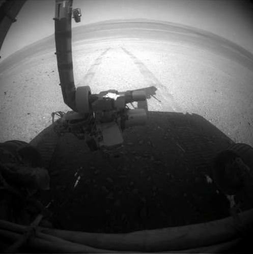
The Opportunity Mars rover looks back at the tracks left along the rim of Endeavour Crater. Credit: NASA/JPL-Caltech

Meanwhile, back in Meridiani Planum … the Opportunity rover keeps on trucking, and has now exceeded over 35 kilometers (21.75 miles) of driving on its odometer! Quite an accomplishment for the Energizer Bunny of Mars rovers, now operating for 3,057 Martian sols. As the MER team says, “Not bad for a vehicle designed for only about 1 kilometer (.6 miles) of distance and 90 sols (days) of lifetime.”

Oppy is now moving south along the inboard edge of Cape York on the rim of Endeavour Crater surveying exposed outcrop in search of phyllosilicate clay minerals that have been detected from orbit. These outcrops are quite interesting and attention-grabbing; here’s a look in color from Stuart Atkinson:

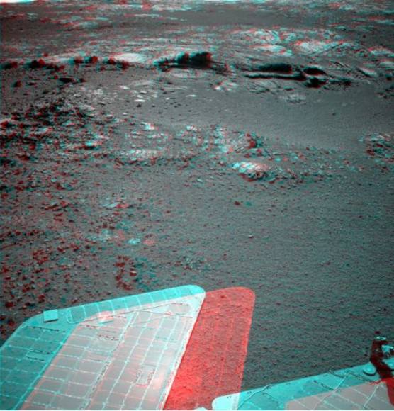
and in 3-D:

Wow!

As Stu writes in his Road to Endeavour blog, “What are those rocks made of? How did this feature form? What do the diferent colours and textures mean? These are all questions which the MER team will be hoping to answer over the next few days, I’m sure. I think we’ll see Oppy driving closer to this outcrop and studying it in a lot of detail.”

The MER team reports that on Sol 3055 (Aug. 27, 2012), the Rock Abrasion Tool (RAT) on the end of the robotic arm was imaged (top image) to re-confirm the available bit for future grinding and the Alpha Particle X-ray Spectrometer (APXS) collected a measurement of atmospheric argon.

Opportunity’s solar array energy production is good, producing about 568 watt-hours.

So, even though the Curiosity rover is grabbing the headlines, don’t forget that Opportunity is still keepin’ on, working hard on Mars.

Sources: NASA/JPL, Road to Endeavour