Pacific Glory

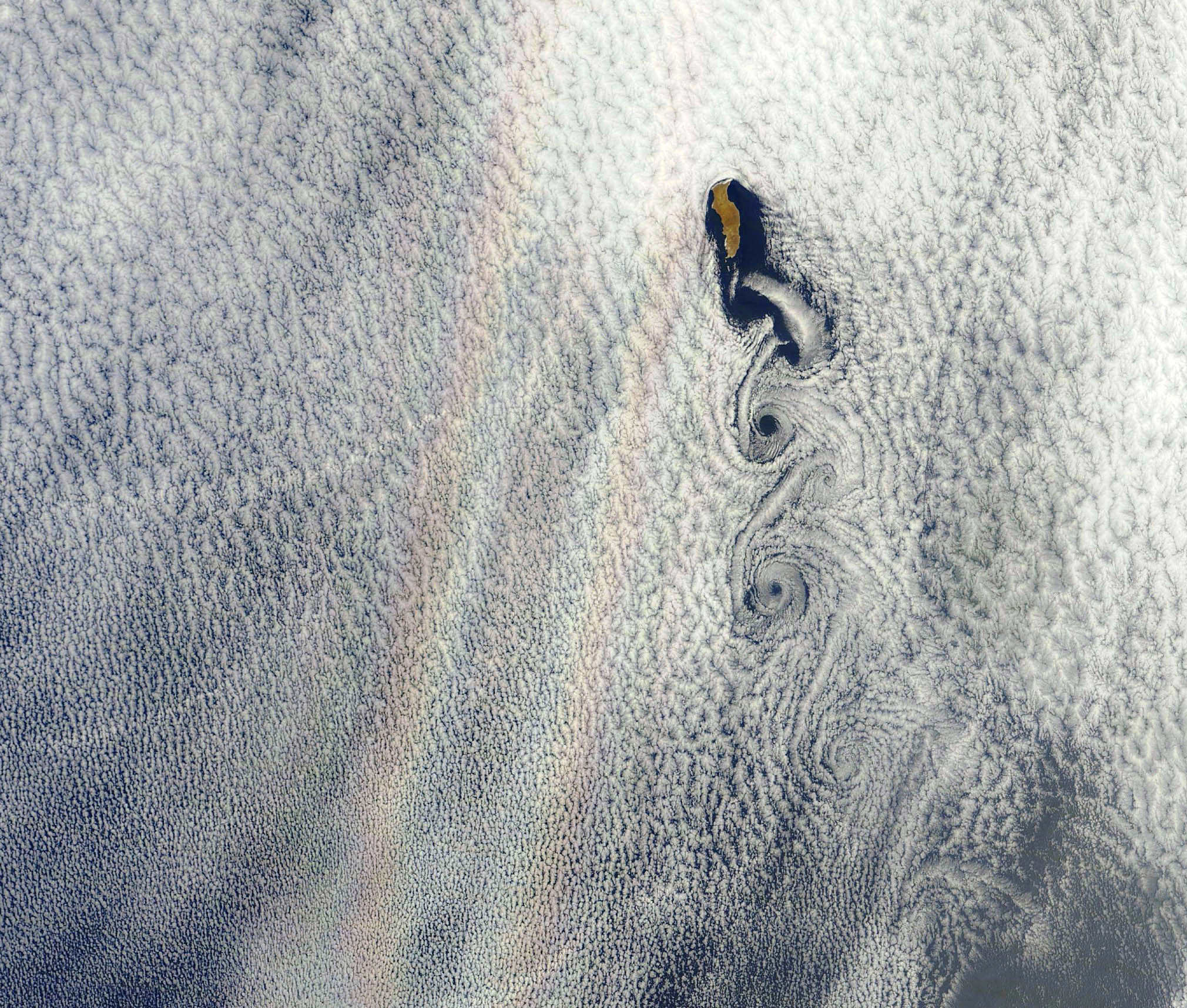
An optical phenomenon known as a “glory” is seen over a cloud-covered Pacific Ocean in this image from NASA’s Aqua satellite, acquired on June 20, 2012. Although the colors may make it look like a rainbow, the process behind its formation is somewhat different.

As vortices spiral off the leeward side of Guadalupe Island, off the western coast of Baja California, a shimmering spectrum of colors highlights a glory just west of the island. Glories are created when light from the Sun reflects back toward an observer off water droplets within clouds or fog. They are often seen from airplanes as a bright ring of light encircling a silhouetted shadow of the aircraft below, but are also visible from the ground and, sometimes, even from space.

From the NASA Earth Observatory website:

Although glories may look similar to rainbows, the way light is scattered to produce them is different. Rainbows are formed by refraction and reflection; glories are formed by backward diffraction. The most vivid glories form when an observer looks down on thin clouds with droplets that are between 10 and 30 microns in diameter. The brightest and most colorful glories also form when droplets are roughly the same size.

From the ground or an airplane, glories appear as circular rings of color. The space shuttle Columbia observed a circular glory from space in 2003. In the image above, however, the glory does not appear circular. That’s because MODIS scans the Earth’s surface in swaths perpendicular to the path followed by the satellite. And since the swaths show horizontal cross sections through the rings of the glory, the glory here appears as two elongated bands of color that run parallel to the path of the satellite, rather than a full circle.

Glories always appear around the spot directly opposite the Sun, from the perspective of the viewer. This spot is called the anti-solar point. To visualize this, imagine a line connecting the Sun, a viewer, and the spot where the glory appears. In this case, the anti-solar point falls about halfway between the two colored lines of the glory.

Click here to download the full-size image.

NASA image courtesy Jeff Schmaltz, LANCE MODIS Rapid Response. Read more here.

There’s a Hole in the Sky!

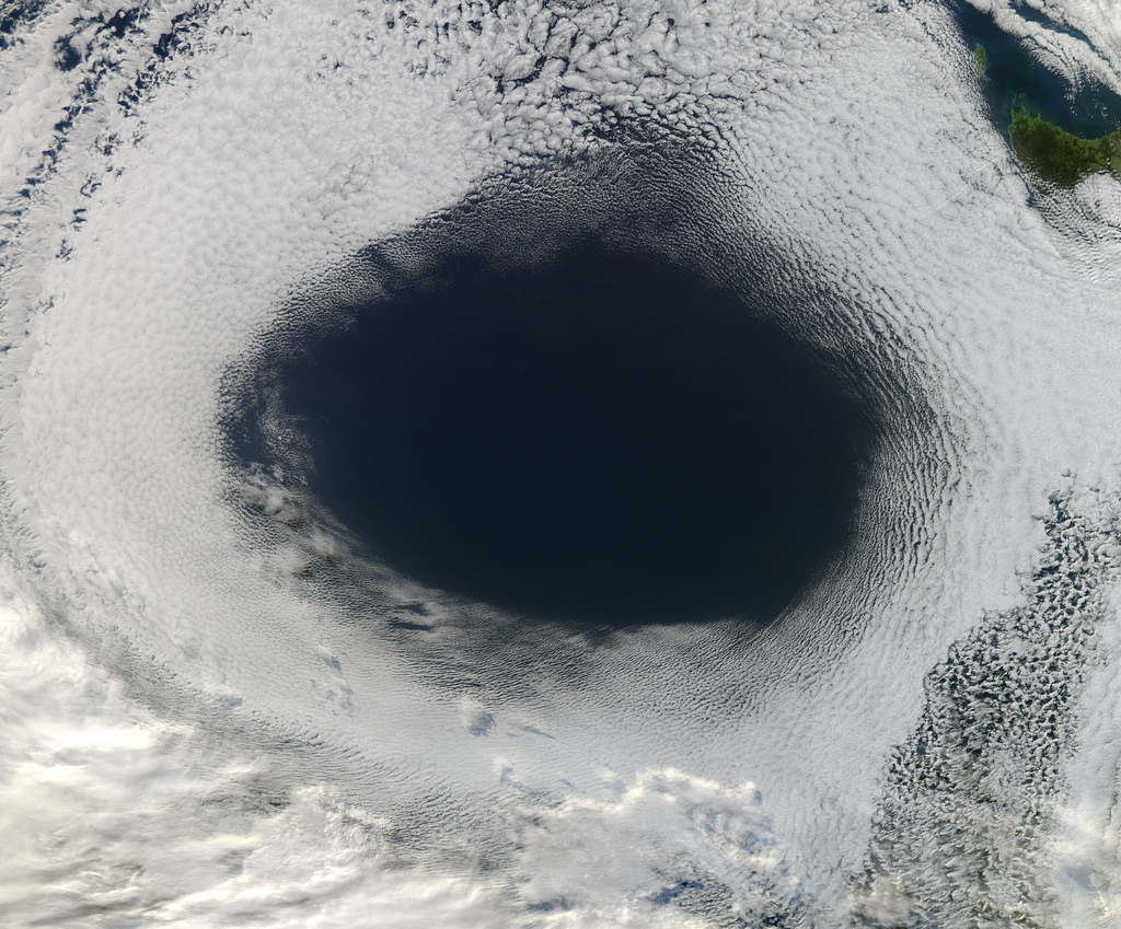
A vast hole in the cloud cover seen over the southern Pacific

[/caption]

Well, not the sky exactly, but definitely in the clouds!

This image, acquired by NASA’s Aqua satellite on June 5, shows an enormous oval hole in the clouds above the southern Pacific Ocean, approximately 500 miles (800 km) off the southwestern coast of Tasmania. The hole itself is several hundred miles across, and is the result of high pressure air in the upper atmosphere.

According to Rob Gutro of NASA’s Goddard Space Flight Center, “This is a good visible example of how upper-level atmospheric features affect the lower atmosphere, because the cloud hole is right under the center of a strong area of high pressure. High pressure forces air down to the surface blocking cloud formation. In addition, the altocumulus clouds are rotating counter-clockwise around the hole, which in the southern hemisphere indicates high pressure.”

The northwestern tip of Tasmania and King Island can be seen in the upper right of the image.

The Aqua mission is a part of the NASA-centered international Earth Observing System (EOS). Launched on May 4, 2002, Aqua has six Earth-observing instruments on board, collecting a variety of global data sets about the Earth’s water cycle. Read more about Aqua here.

Awesome Video of a Dragon’s Descent!

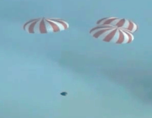
Dragon's Apollo-esque drogue chutes deployed (NASA)


Just in from SpaceX and NASA, here’s a video of the descent of the Dragon capsule on the morning of May 31, 2012.

[/caption]

Taken from a chase plane, the footage shows the spacecraft’s dramatic chute deployment and splashdown into the Pacific at 8:42 a.m. PT, approximately 560 miles southwest off the coast of Los Angeles. The event marked the end of a successful and historic mission that heralds a new era of commercial spaceflight in the U.S.

Read more about the completion of the first Dragon mission here.

Video: NASA

The Other End of an Eclipse

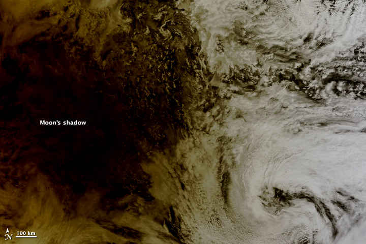
The Moon's shadow falling over the Pacific on May 20, 2012

[/caption]

As the annular eclipse on May 20 sent skywatchers around the globe gazing upwards to see the Sun get darkened by the Moon’s silhouette, NASA’s Terra satellite caught the other side of the event: the Moon’s shadow striking the Earth!

Cast across 240,000 miles of space, the lunar shadow darkened a circular swatch 300 km (185 miles) wide over the northern Pacific Ocean in this image, acquired by the Earth-observing Terra satellite’s Moderate Resolution Imaging Spectroradiometer (MODIS) at 20:30 UT on Sunday, May 20.

From the NASA Earth Observatory site:

Where the Moon passed in front of the Sun, Earth’s surface appeared black (left half of image). Around the margins of the shadow, our planet’s surface appeared yellowish brown. The shadow cast by an eclipse consists of two parts, the completely shadowed umbra and the partially shadowed penumbra.

The eclipse was first visible over eastern Asia and moved across the globe, later becoming visible on the west coast of the US. Known as an annular eclipse, even in totality there was a bright ring of Sun visible around the Moon — a result of the Moon’s elliptical orbit. The effect was dramatic, and was captured in some amazing photos from viewers around the world (as well as by a few above the world!)

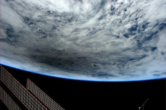
Looking at Earth during the Annular Solar Eclipse of May 20, 2012, photographed by Don Pettit from the International Space Station at 23:36 GMT. (NASA)

Although there were a few images being circulated online of the “eclipse” that were not actual photos, be assured that these are the real deal.

And the next eclipse event? That will occur on November 13 of this year, when a total eclipse will be visible from Australia, the South Pacific and South America. Watch an animation of the Nov. 13 eclipse visibility here.

Top image: NASA/Jeff Schmaltz, LANCE MODIS Rapid Response.