What are Plate Boundaries?

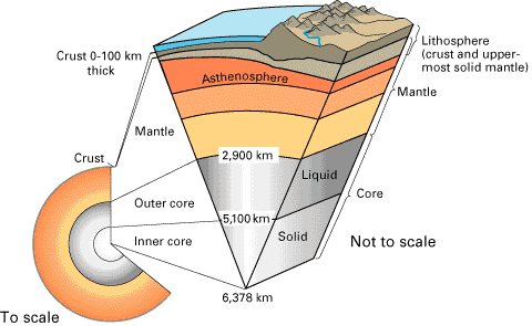
In Plate Tectonic Theory, the lithosphere is broken into tectonic plates, which undergo some large scale motions. The boundary regions between plates are aptly called plate boundaries. Based upon their motions with respect to one another, these plate boundaries are of three kinds: divergent, convergent, and transform.

Divergent Boundaries:

Divergent boundaries are those that move away from one another. When they separate, they form what is known as a rift. As the gap between the two plates widen, the underlying layer may be soft enough for molten lava underneath to push its way upward. This upward push results in the formation of volcanic islands. Molten lava that succeeds in breaking free eventually cools and forms part of the ocean floor.

Some formations due to divergent plate boundaries are the Mid-Atlantic Ridge and the Gakkel Ridge. On land, you have Lake Baikal in Siberia and Lake Tanganyika in East Africa.

Convergent Boundaries:

Convergent boundaries are those that move towards one another. When they collide, subduction usually takes place. That is, the denser plate gets subducted or goes underneath the less dense one. Sometimes, the plate boundaries also experience buckling. Convergent boundaries are responsible for producing the deepest and tallest structures on Earth.

Among those that have formed due to convergent plate boundaries are K2 and Mount Everest, the tallest peaks in the world. They formed when the Indian plate got subducted underneath the Eurasian plate. Another extreme formation due to the convergent boundary is the Mariana Trench, the deepest region on Earth.

Transform Boundaries:

Transform boundaries are those that slide alongside one another. Lest you imagine a slippery, sliding motion, take note that the surfaces involved are exposed to huge amounts of stress and strain and are momentarily held in place. As a result, when the two plates finally succeed in moving with respect to one another, huge amounts of energy are released. This causes earthquakes.

The San Andreas fault in North America is perhaps the most popular transform boundary. Transform boundary is also known as transform fault or conservative plate boundary.

Movements of the plates are usually just a few centimeters per year. However, due to the huge masses and forces involved, they typically result in earthquakes and volcanic eruptions. If the interactions between plate boundaries involve only a few centimeters per year, you could just imagine the great expanse of time it had to take before the land formations we see today came into being.

You can read more about plate boundaries here in Universe Today. Here are the links:

Here are the links of two more articles from USGS:

Here are two episodes at Astronomy Cast that you might want to check out as well:

Sources:
Plate Boundaries
http://pubs.usgs.gov/gip/dynamic/understanding.html

Famous Earthquakes

Earthquakes are among the most devastating forces of nature. What we have are seven of the world’s most famous earthquakes, chronologically listed below. Not all included here are necessarily the strongest (in terms of magnitude) but they made the headlines when they hit. Here they are:

Shaanxi Earthquake of 1556

– This was the deadliest quake ever recorded. It claimed the lives of about 830,000 people. At that time, most inhabitants in the affected areas were living in Yaodongs or artificial caves. They were buried alive when the huge tremors caused the cliffs in which these caves were located in, to collapse.

San Francisco Earthquake of 1906

– Although its tremors were also felt in Southern Oregon, it is the resulting fire in San Francisco that had a more devastating impact on the economy. Is has been often compared recently to Hurricane Katrina because of its similar economic bearing.

The Great Chilean Earthquake of 1960

– Like the one that hit Asia in 2004, this 9.5-rated quake resulted in a massive tsunami reaching up to as high as 10.7 meters. This magnitude is the highest recorded ever. Although the tsunami originated in Cañete, Chile, the waves raced north-westward to Japan and the Philippines, wreaking havoc there.

Great Alaska Earthquake of 1964

– With a magnitude of 9.2, it is the second strongest earthquake to be ever recorded. It caused tsunamis, landslides, and resulted in major landscape changes. Some places near Kodiak is said to have been raised 9.1 meters high, while those near Portage were dropped by 2.4 meters. Here are more articles about Alaska earthquakes.

Great Tangshan Earthquake of 1976

– This is the deadliest quake of the 20th Century, with the number of deaths hitting somewhere near 250,000. Weak building structures and the time this disaster struck (4 am) contributed a lot to that sickening number.

Bam Earthquake of 2003

– The death toll in this tremor reached over 26,000. Like the one in Tangshan, the use of poor construction materials was one of the leading culprits for the deaths. Most of the affected buildings were made of mud bricks.

Indian Ocean Earthquake of 2004

– The resulting tsunami that killed 230,000 people was caused by a subduction between the India and Burma plate. Its 30 m-high waves destroyed virtually everything in its path, making this quake not only one of the most famous earthquakes but also one of the famous natural disasters in history.

Excluding poor building infrastructure, we can see that high death tolls in these famous earthquakes result when the tremors are accompanied by tsunamis. This happens when the quake’s epicenter is found at the bottom of the ocean.

You can read more about famous earthqueakes here in Universe Today. Here are the links:

There’s more about it at USGS. Here are a couple of sources there:

Here are two episodes at Astronomy Cast that you might want to check out as well:

Sources:
http://en.wikipedia.org/wiki/1906_San_Francisco_earthquake
http://en.wikipedia.org/wiki/2006_Hawaii_earthquake
http://en.wikipedia.org/wiki/1556_Shaanxi_earthquake
http://earthquake.usgs.gov/earthquakes/world/events/1960_05_22.php
http://en.wikipedia.org/wiki/1964_Alaska_earthquake
http://en.wikipedia.org/wiki/1976_Tangshan_earthquake
http://en.wikipedia.org/wiki/2003_Bam_earthquake
http://en.wikipedia.org/wiki/2004_Indian_Ocean_earthquake_and_tsunami

What are Divergent Boundaries?

Pangaea
Pangea animation

Divergent boundaries are one of the bi-products of plate tectonics. As the name implies, divergent boundaries are formed when two adjacent tectonic plates separate, i.e., when they diverge.

When tectonic plates start to diverge, the linear feature formed is called a rift. Sometimes, the gap widens and sometimes it stops. When the gap eventually widens, it then evolves into a rift valley. Divergent boundaries that occur between oceanic plates produce mid-oceanic ridges.

In places where molten lava is able to move up and fill the gap, volcanic islands are eventually formed. Molten lava that rises eventually cools and forms part of the ocean floor.

One divergent boundary is the Mid-Atlantic Ridge, found at the bottom of the Atlantic and is the longest mountain range in the world. That’s right, the longest mountain range is hidden from our view. Imagine how astonished crew members of the HMS Challenger were when they discovered the massive rise underneath them. The Challenger expedition was dedicated to scientific discoveries the became foundations of oceanography. The Mid-Atlantic Ridge was observed by the HMS Challenger in 1872.

The record for the slowest divergent boundary in the world goes to Gakkel Ridge between the North American Plate and the Eurasian Plate in the Arctic Ocean. Its annual rate of separation is less than one centimeter – that’s about half as fast the rate your fingernails grow. Robotic submersibles belonging to the AGAVE expedition discovered microbial communities of over a dozen new species on this ridge.

Although not as common, rift valleys can also be formed on land. One example is the Basin and Range province in Nevada and Utah. The world’s largest freshwater lakes such as Siberia’s Lake Baikal and East Africa’s Lake Tanganyika are found in rift valleys.

One of the favorite natural laboratories for the study of divergent plate boundaries is Iceland. The Mid-Atlantic Ridge runs beneath Iceland and as the North American Plate moves westward while the Eurasian Plate moves eastward, Iceland will slowly be sliced in half. When water rushes in to fill the widening gap, this huge island of ice will form two smaller islands.

How far can divergent boundaries go? Well if we look at a time frame of 100 to 200 million years, we can easily spot the Atlantic Ocean. What is believed to have been a tiny inlet of water between the formerly merged Europe, Africa, and Americas has now evolved into this vast expanse of water.

You can read more about divergent boundaries here in Universe Today. Here are the links:

There’s more about it at USGS. Here are a couple of sources there:

Here are two episodes at Astronomy Cast that you might want to check out as well:

Sources:
Plate Boundaries
http://pubs.usgs.gov/gip/dynamic/understanding.html
http://en.wikipedia.org/wiki/Divergent_boundary
http://geology.com/nsta/divergent-plate-boundaries.shtml

Continental Crust

The crust is the top layer of the Earth’s Surface. Did you know that there are 2 types, though? One is called the Oceanic Crust, and the other, the Continental Crust. As its name suggests, the Oceanic Crust is the top layer of Earth that forms the ocean floor. The Continental Crust, however, will be our focus.

We walk on top of and dig down through the Continental Crust when we plant or drill. Even if there is an unstable surface at the very top, like sand, the deeper parts of the Crust are made of harder rocks. The large land masses, continents, have bases made from sedimentary, igneous, or metamorphic rocks, as well as any combination thereof. This shield rock is the oldest known; it’s been tested, dated, and found to have been here for 3,960,000,000 years!

Geologists, scientists who study the Earth, believe that shield rock was created when hot molten iron, known as magma cooled. If their math’s correct, it happened around the time these rocks formed, almost 4 billion years ago, right? Some of those rocks were so big it took a long time for them to cool. So, even if the rocks were formed 3.9 billion years ago, they might not have cooled for quite some time. Many estimate that the Continental Crust wasn’t completely hard for another 60,000,000 to 160,000,000 years.

The top portion of this rock has another name, platform rock. The oldest-known platform rocks are approximately 600,000,000 years old, and can be found in central North America. The sedimentary rock ranges from 1,000 to 2,000 meters thick; that is equivalent to more than a half mile to 1.25 miles. When we put the top and bottom portions of the Continental Crust together, we get what scientists call, a craton. Most cratons are stable and haven’t been damaged by earthquakes or volcanoes for hundreds of millions of years.

Around the edges are the continental margins, mostly created by sedimentary rock originally found in the oceans. How is that possible, you ask? Well, it’s due to earthquake and volcanic activity. In this case, it’s mainly due to a phenomenon called, subduction. You see, the Earth fits together like a puzzle; and, if you try to place the wrong piece into a spot where it fits, but isn’t quite right, what happens? Another piece might pop out of place. Sometimes, a continental margin works its way under the oceanic crust. When that occurs, the oceanic layer ends up on top of the continental margin. This is subduction. The most well-known place for this is along The Ring of Fire, an area that covers the edges along the Pacific Ocean. This is why so many and such violent earthquakes, volcanic eruptions, and tsunamis occur in that part of the world.

Universe Today has a wealth of information on this and other related topics. Here are just 2 of those available. The first is entitled,
Earth, Barely Habitable?.

The second is called, Interesting Facts About Planet Earth.

Universe Today also hosts Astronomy Cast, a science program that covers a variety of subjects. Episode 51: Earth, explains this subject in greater detail.

The Encyclopedia of Earth , by Michael Pidwirny has some excellent information, too.

Sources:
USGS
Science Daily