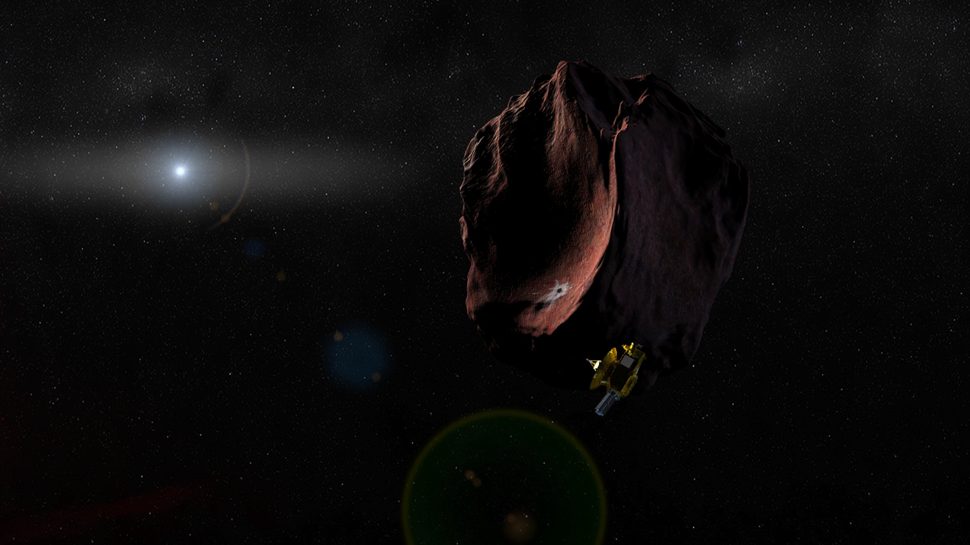
Artist's impression of NASA's New Horizons spacecraft encountering a Pluto-like object in the distant Kuiper Belt. (Credit: NASA/Johns Hopkins University Applied Physics Laboratory/Southwest Research Institute/Steve Gribben)
Even though the New Horizons spacecraft hasn’t officially been approved to do a flyby of a distant Kuiper Belt Object in about 3 years, the engineering team has now performed two maneuvers in a series of four to direct the spacecraft towards an ancient and distant KBO named 2014 MU69.
“Second of four engine burns to target our KBO was completed successfully!! Go New Horizons! Go NASA!” said Principal Investigator Alan Stern on Facebook.
Two more burns will occur within the next 8 days.
The 25-minute burn on October 25 was the largest propulsive maneuver ever conducted by New Horizons. The team said that the spacecraft is in excellent health as it continues to transmit data from the Pluto system flyby in July. It is currently zooming through deep space at more than 52,000 km/hr (32,000 miles per hour) and it is now about 122 million kilometers (76 million miles) past Pluto and 5.09 billion kilometers (3.16 billion miles) from Earth.
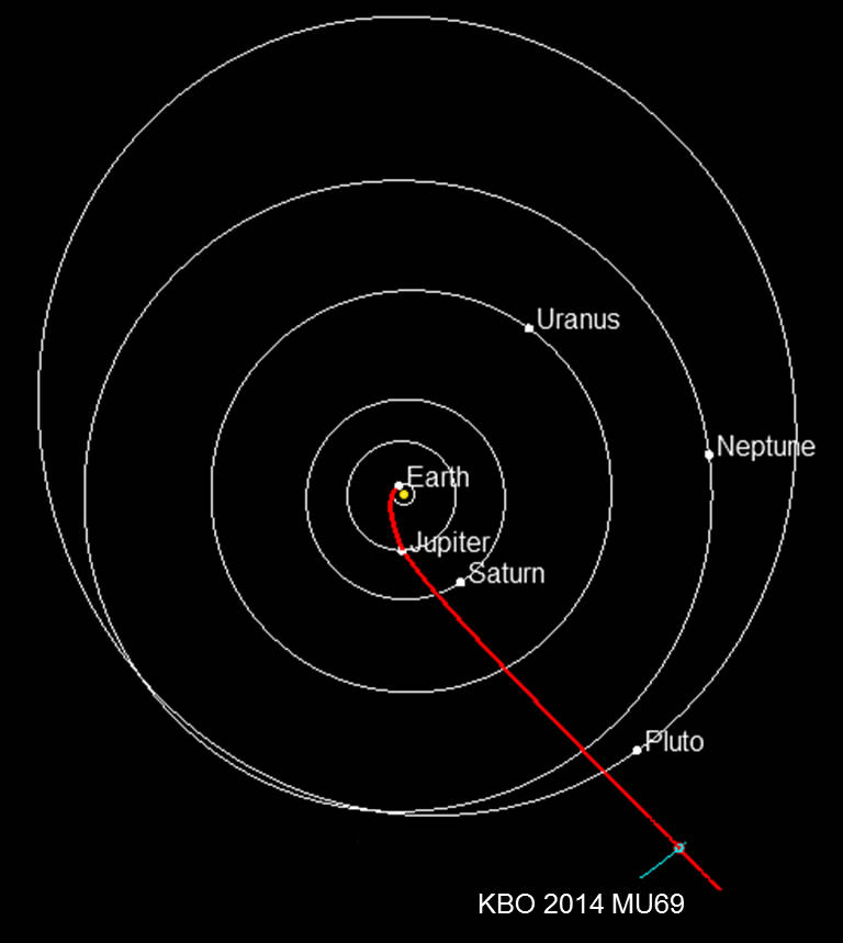
Projected path of NASA’s New Horizons spacecraft toward 2014 MU69, which orbits in the Kuiper Belt about 1 billion miles beyond Pluto. Planets are shown in their positions on Jan. 1, 2019, when New Horizons is projected to reach the small Kuiper Belt object. NASA must approve an extended mission for New Horizons to study MU69. Credit: New Horizons team.
New Horizons must travel about a billion miles to get to 2014 MU69, which is also nicknamed “PT1” (for “Potential Target 1”) and if all continues to go well, the spacecraft is expected to reach the KBO on January 1, 2019.
“2014 MU69 is a great choice because it is just the kind of ancient KBO, formed where it orbits now, that the Decadal Survey desired us to fly by,” Stern said back in August 2015 when the target was announced. “Moreover, this KBO costs less fuel to reach [than other candidate targets], leaving more fuel for the flyby, for ancillary science, and greater fuel reserves to protect against the unforeseen.”
The 2003 National Academy of Sciences’ Planetary Decadal Survey recommended that the first mission to the Kuiper Belt include flybys of Pluto and small KBOs, in order to sample the diversity of objects in that previously unexplored region of the solar system. PT1 is a completely different class of KBO than Pluto.
New Horizons has hydrazine-fueled thrusters, and it carries enough fuel for the flyby, but the team really wants to have the other two maneuvers carried out as scheduled on Oct. 28 and Nov. 4, in order to make the fuel last as long as possible.
The New Horizons team will submit a formal proposal to NASA for the KBO flyby in early 2016. NASA officials have said the discussions on whether to approve this extended mission will take place in the larger context of the planetary science portfolio, i.e., to see if it fits in the budget.
Given the success of the Pluto system flyby, and the success so far of the maneuvers to send the spacecraft to PT1, it would be a grave mistake not to take advantage of this opportunity.
This global view of Jupiter's moon, Io, was obtained during the tenth orbit of Jupiter by NASA's Galileo spacecraft. Credit: NASA
Exploring the Solar System is like peeling an onion. With every layer removed, one finds fresh mysteries to ponder over, each one more confounding than the last. And this is certainly the case when it comes to Jupiter’s system of moons, particularly its four largest – Io, Europa, Ganymede and Callisto. Known as the Galilean Moons, in honor of their founder, these moons possess enough natural wonders to keep scientists busy for centuries.
As Jupiter’s innermost moon, it is also the fourth-largest moon in the Solar System, has the highest density of any known moon, and is the driest known object in the Solar System. It is also one of only four known bodies that experiences active volcanism and – with over 400 active volcanoes – it is the most geologically active body in the Solar System.
This image was taken by the Long Range Reconnaissance Imager (LORRI) on NASA's New Horizons spacecraft shortly before closest approach to Pluto on July 14, 2015; it resolves details as small as 270 yards (250 meters). The scene shown is about 130 miles (210 kilometers) across. The sun illuminates the scene from the left, and north is to the upper left.
Credits: NASA/JHUAPL/SwRI
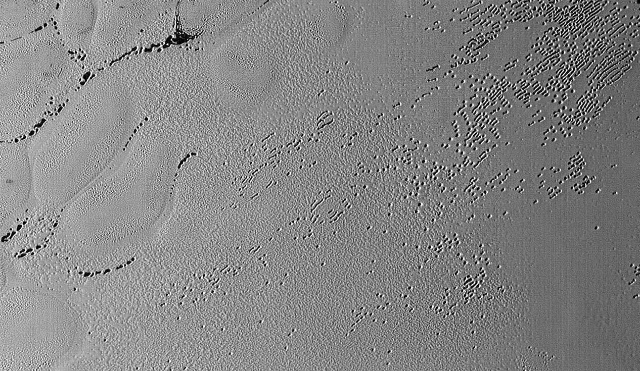
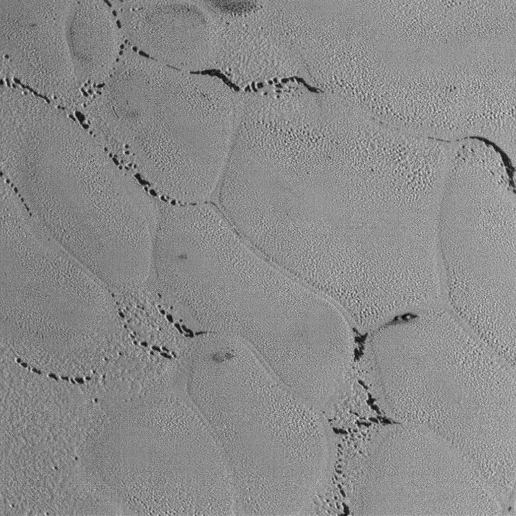
A brand new batch of Pluto and Charon photos showed up today on the New Horizons LORRI (LOng-Range Reconnaissance Imager) site. The photos were taken during the close flyby of the system on July 14, 2015 and show rich detail including craters and parallel cracks on Charon and thousands of small pits punctuating Pluto’s nitrogen ice landscape. Have at ’em!
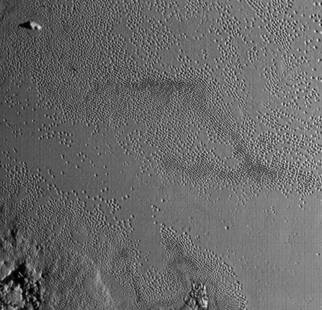
This wider view shows the snakeskin-like textured surface of Pluto’s icy plains riddled with small pits. It almost looks like the dark areas in the sinuous channels between the mounds were once covered with frost or ice that has since sublimated away. They look similar to the polar regions on Mars where carbon dioxide frost burns off in the spring to reveal darker material beneath. Credit: NASA/JHUAPL/SwRI
The first couple images feature the region informally known as Sputnik Planum. According to a releasefrom NASA today, scientists think the region is composed of volatile ices such as solid nitrogen. They theorize that the pits and troughs – typically hundreds of meters across and tens of meters deep – are possibly formed by sublimation or evaporation of these ices in Pluto’s thin atmosphere. Still, their curious shapes and alignments remain a mystery. Adding to the intrigue is that even when seen up close, no impact craters are visible, testifying to the icy plain’s extreme geologic youth.
By the way, there are more images at the LORRI link at top. I picked a representative selection but I encourage you to visit and explore.
Now that’s what I call getting a photo in low light. Sunlight scrapes across rugged mountains as well as highlight the ubiquitous pitted terrain. Credit: NASA/JHUAPL/SwRILife’s definitely the pits on Pluto’s Tombaugh Regio. This photo shows the fainter “ghost” pits well. Is ice filling them in or are we seeing the beginning of a pit’s formation? Credit: NASA/JHUAPL/SwRIA fine view of Pluto’s largest moon Charon and its vast canyon system. Credit: NASA/JHUAPL/SwRILooking over Charon’s dark north polar region, the border of which is highlighted by several beautiful rayed craters. Not that it’s necessarily related, but the dark spot reminds me of a lunar mare or sea. On the moon, cracks in the crust allowed lava to fill gigantic basins to create the maria. Could material from beneath Charon have bubbled up to fill an ancient impact? Credit: NASA/JHUAPL/SwRISpeaking of the Moon, the large cracks at left resemble lunar rills, some of which formed through faulting / fracturing and others as conduits for lava flows. The multiple, fine cracks are interesting. Credit: NASA/JHUAPL/SwRISplendid rayed crater with an interesting contrast between dark and light ejecta. Credit: NASA/JHUAPL/SwRIA busy region on Charon, the meeting place of different terrains. Credit: NASA/JHUAPL/SwRI
Special Guest: Dr. Carolyn Porco is the leader of the Cassini Imaging Science team and the Director of the Cassini Imaging Central Laboratory for Operations (CICLOPS) at the Space Science Institute in Boulder, Colorado.
Pluto’s Blue Sky: Pluto’s haze layer shows its blue color in this picture taken by the New Horizons Ralph/Multispectral Visible Imaging Camera (MVIC). The high-altitude haze is thought to be similar in nature to that seen at Saturn’s moon Titan. The source of both hazes likely involves sunlight-initiated chemical reactions of nitrogen and methane, leading to relatively small, soot-like particles (called tholins) that grow as they settle toward the surface. Credits: NASA/JHUAPL/SwRI
With each passing day, significant discoveries about Pluto continue piling up higher and higher as more and more data gathered and stored from this past summer’s historic flyby by NASA’s New Horizons reaches ground stations back here on Earth.
“Blue skies–Pluto is awesome!” says Alan Stern, New Horizons principal investigator from Southwest Research Institute (SwRI), Boulder, Colorado.
The bluish tint to Pluto’s skies were unexpectedly discovered after researchers examined the first color images of the high altitude atmospheric hazes returned by New Horizons last week that were taken by the probes Ralph/Multispectral Visible Imaging Camera (MVIC).
“Who would have expected a blue sky in the Kuiper Belt?” Stern said in a NASA statement.
During New Horizons flyby on July 14, 2015, it discovered that Pluto is the biggest object in the outer solar system and thus the ‘King of the Kuiper Belt.”
The Kuiper Belt comprises the third and outermost region of worlds in our solar system.
“It’s gorgeous!” exclaims Stern.
Moreover, the source of Pluto’s blue haze is different from Earth’s and more related to Titan, Saturn’s largest moon – currently being explored by NASA’s Cassini mission orbiting Saturn since 2004.
On Earth, the blue sky is caused by light scattering off tiny particles of nitrogen molecules. Whereas on Titan its related to soot-like particles called tholins.
Tholins are generated by a series of very complex sunlight-initiated chemical reactions between nitrogen and methane (CH4) high in the atmosphere. This eventually produces relatively small, soot-like particles of complex hydrocarbons.
“That striking blue tint tells us about the size and composition of the haze particles,” said New Horizons science team researcher Carly Howett, of SwRI, in a statement.
“A blue sky often results from scattering of sunlight by very small particles. On Earth, those particles are very tiny nitrogen molecules. On Pluto they appear to be larger — but still relatively small — soot-like particles we call tholins.”
As the tholins rain down on Pluto, they add to the widespread red surface coloring.
The Ralph instrument was also key in another discovery announced by New Horizons researchers.
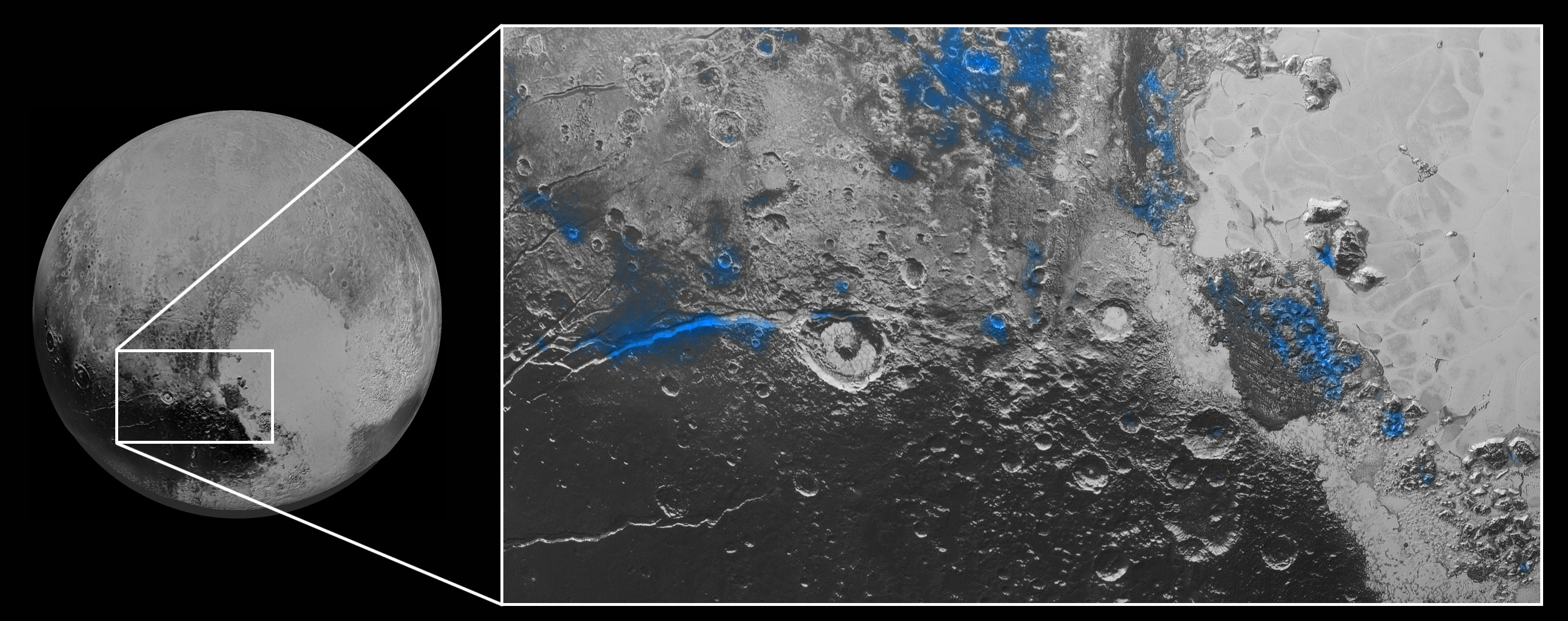
Numerous small, exposed regions of water ice on Pluto’s surface were discovered by combining measurements from the Ralph MVIC spectral composition mapper and infrared spectroscopy from the Linear Etalon Imaging Spectral Array (LEISA) instrument.
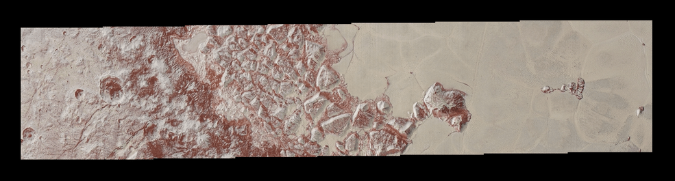
The strongest signatures of water ice were found in the Virgil Fossa and Viking Terra regions berby the western edge of Pluto’s huge heart-shaped Tombaugh Regio feature – see image below.
Water Ice on Pluto: Regions with exposed water ice are highlighted in blue in this composite image from New Horizons’ Ralph instrument, combining visible imagery from the Multispectral Visible Imaging Camera (MVIC) with infrared spectroscopy from the Linear Etalon Imaging Spectral Array (LEISA). The strongest signatures of water ice occur along Virgil Fossa, just west of Elliot crater on the left side of the inset image, and also in Viking Terra near the top of the frame. A major outcrop also occurs in Baré Montes towards the right of the image, along with numerous much smaller outcrops, mostly associated with impact craters and valleys between mountains. The scene is approximately 280 miles (450 kilometers) across. Note that all surface feature names are informal. Credits: NASA/JHUAPL/SwRI
Water ice is only found in certain zones of Pluto for reasons yet to be understood. There may also be a relationship to the tholins, that likewise is yet to be gleaned.
“I’m surprised that this water ice is so red,” says Silvia Protopapa, a science team member from the University of Maryland, College Park. “We don’t yet understand the relationship between water ice and the reddish tholin colorants on Pluto’s surface.”
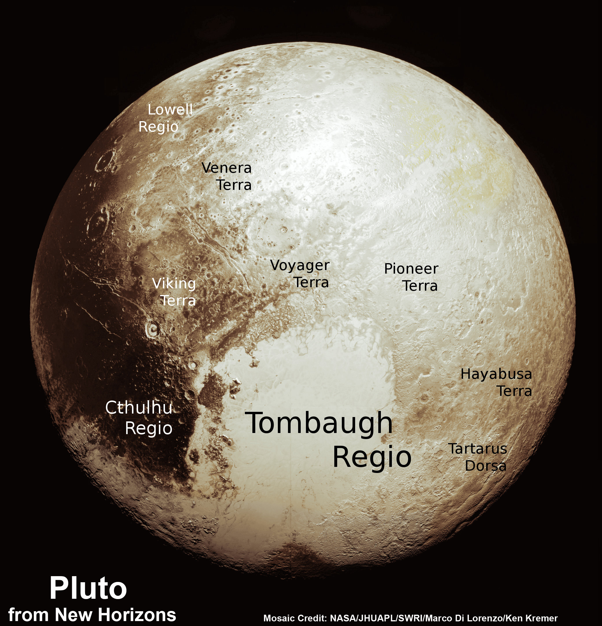
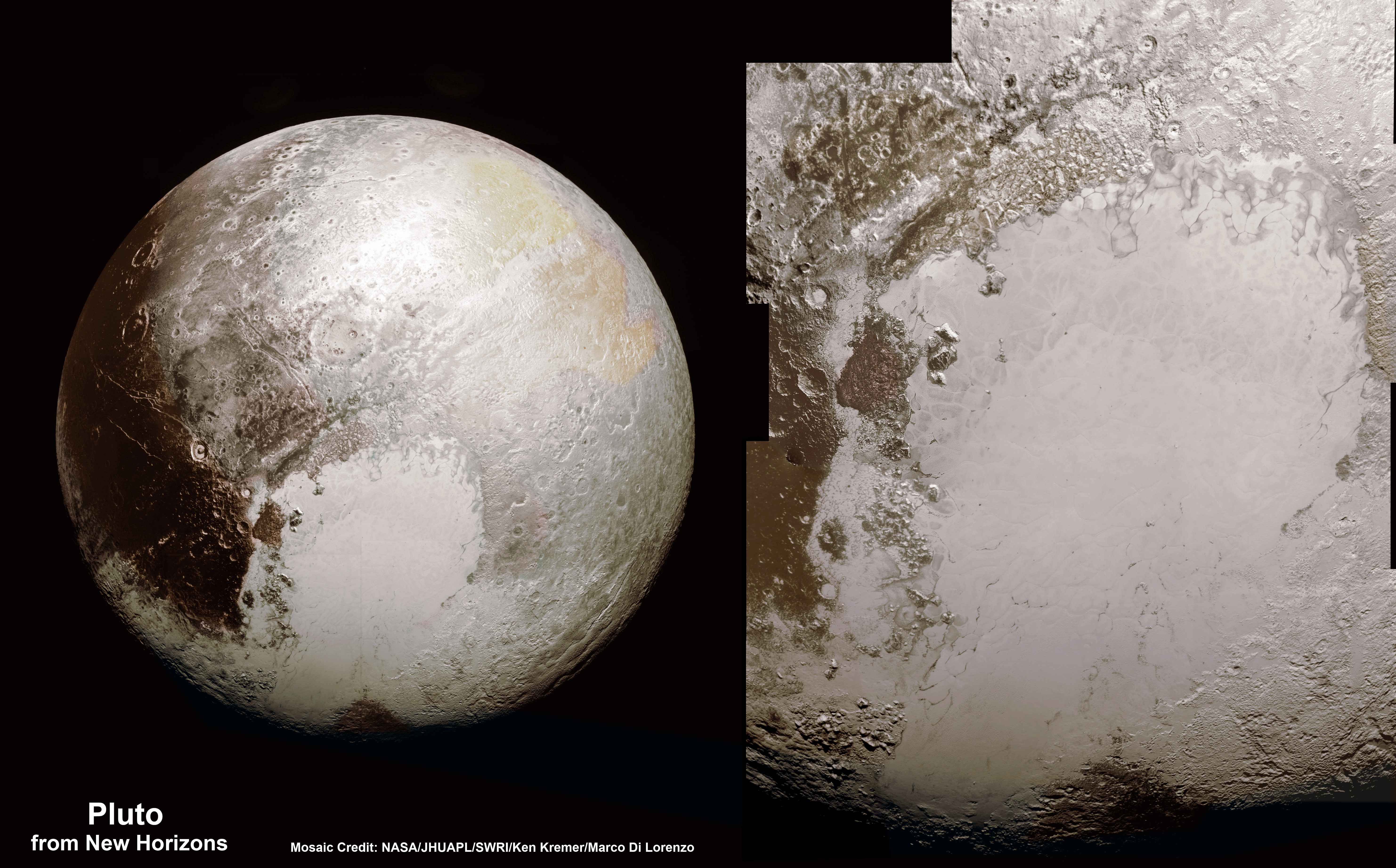
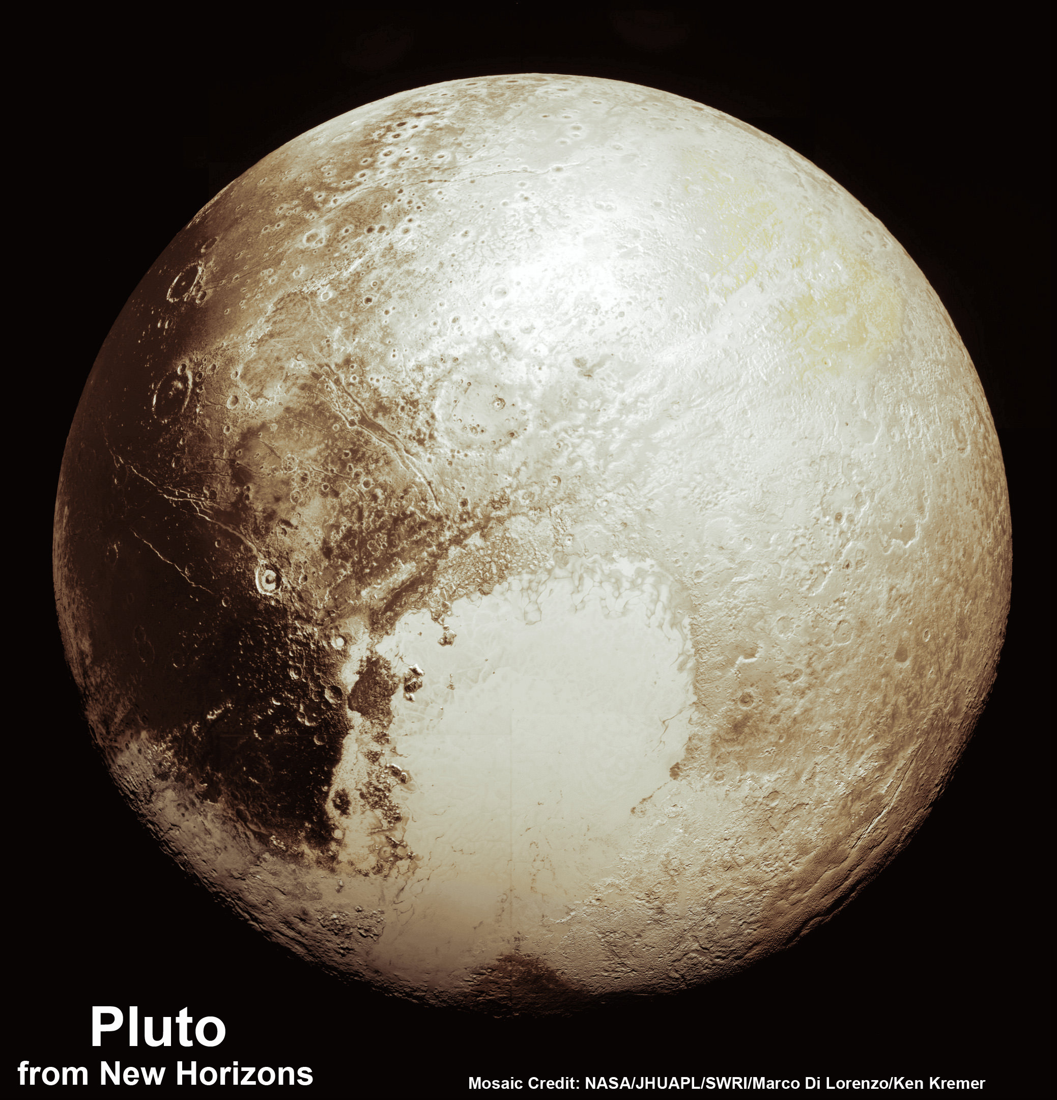
This new global mosaic view of Pluto was created from the latest high-resolution images to be downlinked from NASA’s New Horizons spacecraft and released on Sept. 11, 2015. The images were taken as New Horizons flew past Pluto on July 14, 2015, from a distance of 50,000 miles (80,000 kilometers). This new mosaic was stitched from over two dozen raw images captured by the LORRI imager and colorized. Annotated with informal place names. Credits: NASA/Johns Hopkins University Applied Physics Laboratory/Southwest Research Institute/Marco Di Lorenzo/Ken Kremer/kenkremer.com
As of today, New Horizons remains healthy and is over 3.1 billion miles (5 billion kilometers) from Earth.
The team hopes to fire up the thrusters later this fall to propel the spacecraft toward a second Kuiper Belt Object (KBO) in 2019 tentativley named PT1, for Potential Target 1. It is much smaller than Pluto and was recently selected based on images taken by NASA’s Hubble Space Telescope.
Stay tuned here for Ken’s continuing Earth and planetary science and human spaceflight news.
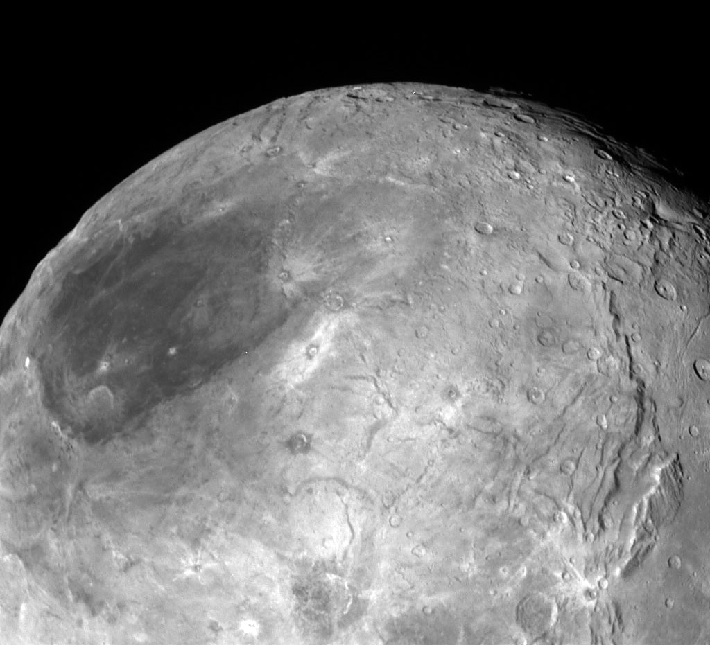
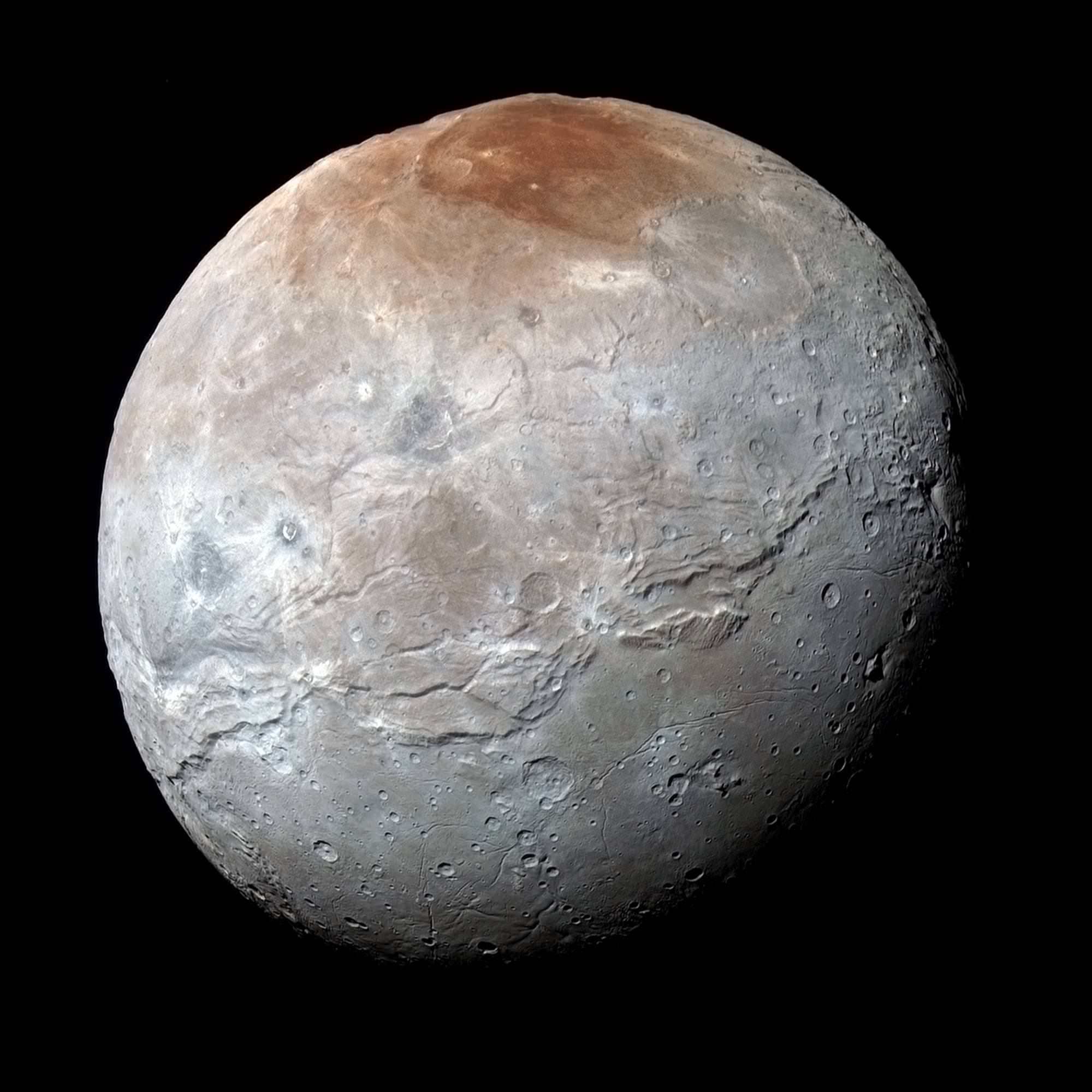
Charon in Enhanced Color. NASA's New Horizons captured this high-resolution enhanced color view of Charon just before closest approach on July 14, 2015. The image combines blue, red and infrared images taken by the spacecraft’s Ralph/Multispectral Visual Imaging Camera (MVIC); the colors are processed to best highlight the variation of surface properties across Charon. Charon’s color palette is not as diverse as Pluto’s; most striking is the reddish north (top) polar region, informally named Mordor Macula. Charon is 754 miles (1,214 kilometers) across; this image resolves details as small as 1.8 miles (2.9 kilometers). Credits: NASA/JHUAPL/SwRI
Charon in Enhanced Color with Grand Canyon
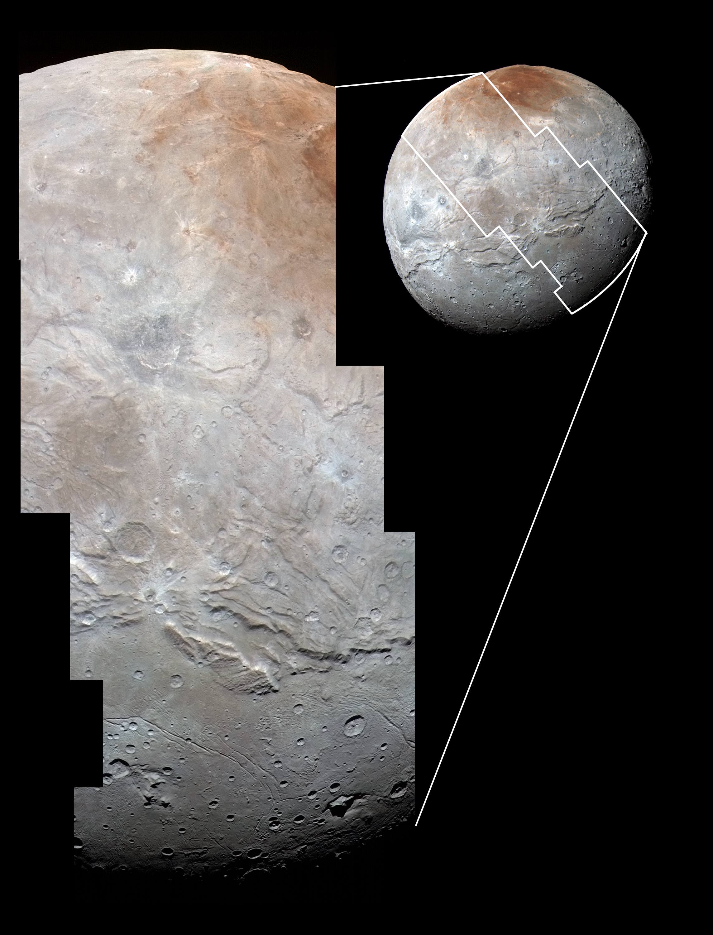
NASA’s New Horizons captured this high-resolution enhanced color view of Charon and its Grand Canyon just before closest approach on July 14, 2015. The image combines blue, red and infrared images taken by the spacecraft’s Ralph/Multispectral Visual Imaging Camera (MVIC); the colors are processed to best highlight the variation of surface properties across Charon. Charon’s color palette is not as diverse as Pluto’s; most striking is the reddish north (top) polar region, informally named Mordor Macula. Charon is 754 miles (1,214 kilometers) across; this image resolves details as small as 1.8 miles (2.9 kilometers). Credits: NASA/JHUAPL/SwRI[/caption]
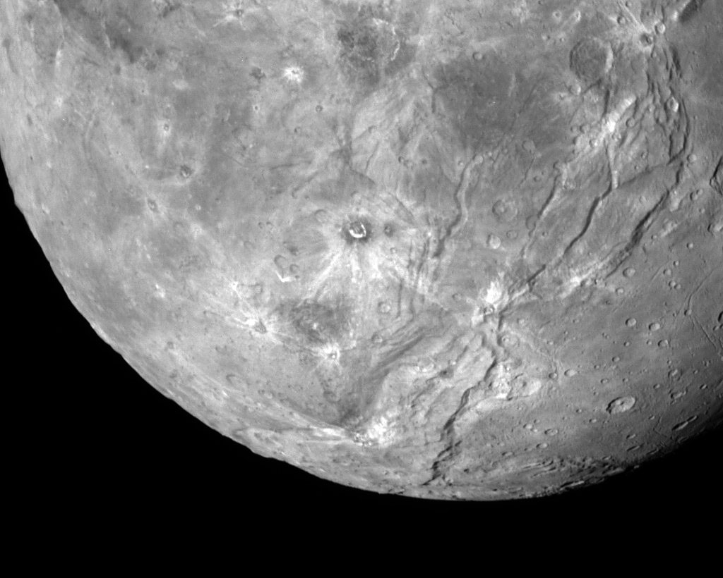
Charon suffered such a surprisingly violent past of titanic upheavals that they created a humongous canyon stretching across the entire face of Pluto’s largest moon – as revealed in a fresh batch of images just returned from NASA’s New Horizons spacecraft.
We have been agog in amazement these past few weeks as New Horizons focused its attention on transmitting astounding high resolution imagery and data of Pluto, captured during mankind’s history making first encounter with our solar systems last unexplored planet on July 14, 2015, at a distance of 7,750 miles (12,500 kilometers).
“You’ll love this,” said New Horizons Principal Investigator Alan Stern of the Southwest Research Institute, Boulder, Colorado, in a blog posting.
Indeed researches say Charon’s tortured landscape of otherworldly canyons, mountains and more far exceeds scientists preconceived notions of a “monotonous, crater-battered world; instead, they’re finding a landscape covered with mountains, canyons, landslides, surface-color variations and more.”
“We thought the probability of seeing such interesting features on this satellite of a world at the far edge of our solar system was low,” said Ross Beyer, an affiliate of the New Horizons Geology, Geophysics and Imaging (GGI) team from the SETI Institute and NASA Ames Research Center in Mountain View, California, in a statement.
“But I couldn’t be more delighted with what we see.”
Measuring 754 miles (1,214 kilometers) across, Charon is half the diameter of Pluto and forms a double planet system. Charon also ranks as the largest satellite relative to its planet in the solar system. By comparison, Earth’s moon is one quarter the size of our home planet.
The new images of the Pluto-facing hemisphere of Charon were taken by New Horizons’ Long Range Reconnaissance Imager (LORRI) and the Ralph/Multispectral Visual Imaging Camera (MVIC) during the July 14 flyby and downlinked over about the past week and a half.
They reveal details of a belt of fractures and canyons just north of the moon’s equator.
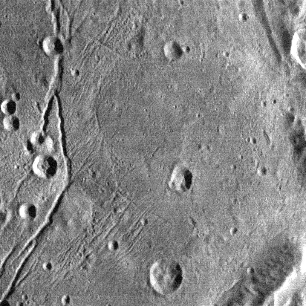
High-resolution images of Charon were taken by the Long Range Reconnaissance Imager on NASA’s New Horizons spacecraft, shortly before closest approach on July 14, 2015, and overlaid with enhanced color from the Ralph/Multispectral Visual Imaging Camera (MVIC). Charon’s cratered uplands at the top are broken by series of canyons, and replaced on the bottom by the rolling plains of the informally named Vulcan Planum. The scene covers Charon’s width of 754 miles (1,214 kilometers) and resolves details as small as 0.5 miles (0.8 kilometers). Credits: NASA/JHUAPL/SwRI
The “Grand Canyon of Charon” stretches more than 1,000 miles (1,600 kilometers) across the entire face of Charon visible in the new images. Furthermore the deep canyon probably extends onto the far side of Pluto and hearkens back to Valles Marineris on Mars.
“It looks like the entire crust of Charon has been split open,” said John Spencer, deputy lead for GGI at the Southwest Research Institute in Boulder, Colorado, in a statement.
“With respect to its size relative to Charon, this feature is much like the vast Valles Marineris canyon system on Mars.”
Charon’s “Grand Canyon” is four times as long as the Grand Canyon of the United States. Plus its twice as deep in places. “These faults and canyons indicate a titanic geological upheaval in Charon’s past,” according to the New Horizons team.
This composite of enhanced color images of Pluto (lower right) and Charon (upper left), was taken by NASA’s New Horizons spacecraft as it passed through the Pluto system on July 14, 2015. This image highlights the striking differences between Pluto and Charon. The color and brightness of both Pluto and Charon have been processed identically to allow direct comparison of their surface properties, and to highlight the similarity between Charon’s polar red terrain and Pluto’s equatorial red terrain. Pluto and Charon are shown with approximately correct relative sizes, but their true separation is not to scale. The image combines blue, red and infrared images taken by the spacecraft’s Ralph/Multispectral Visual Imaging Camera (MVIC). Credits: NASA/JHUAPL/SwRI
Another intriguing finding is the area south of the canyon is much smoother, with fewer craters and may have been resurfaced by a type of “cryovolcanism.”
The southern plains are informally named “Vulcan Planum” and may be much younger.
“The team is discussing the possibility that an internal water ocean could have frozen long ago, and the resulting volume change could have led to Charon cracking open, allowing water-based lavas to reach the surface at that time,” said Paul Schenk, a New Horizons team member from the Lunar and Planetary Institute in Houston.
The piano shaped probe gathered about 50 gigabits of data as it hurtled past Pluto, its largest moon Charon and four smaller moons.
Barely 5 or 6 percent of the 50 gigabits of data captured by New Horizons has been received by ground stations back on Earth due to the slow downlink rate.
Stern says it will take about a year for all the data to get back. Many astounding discoveries await.
“I predict Charon’s story will become even more amazing!” said mission Project Scientist Hal Weaver, of the Johns Hopkins University Applied Physics Laboratory in Laurel, Maryland.
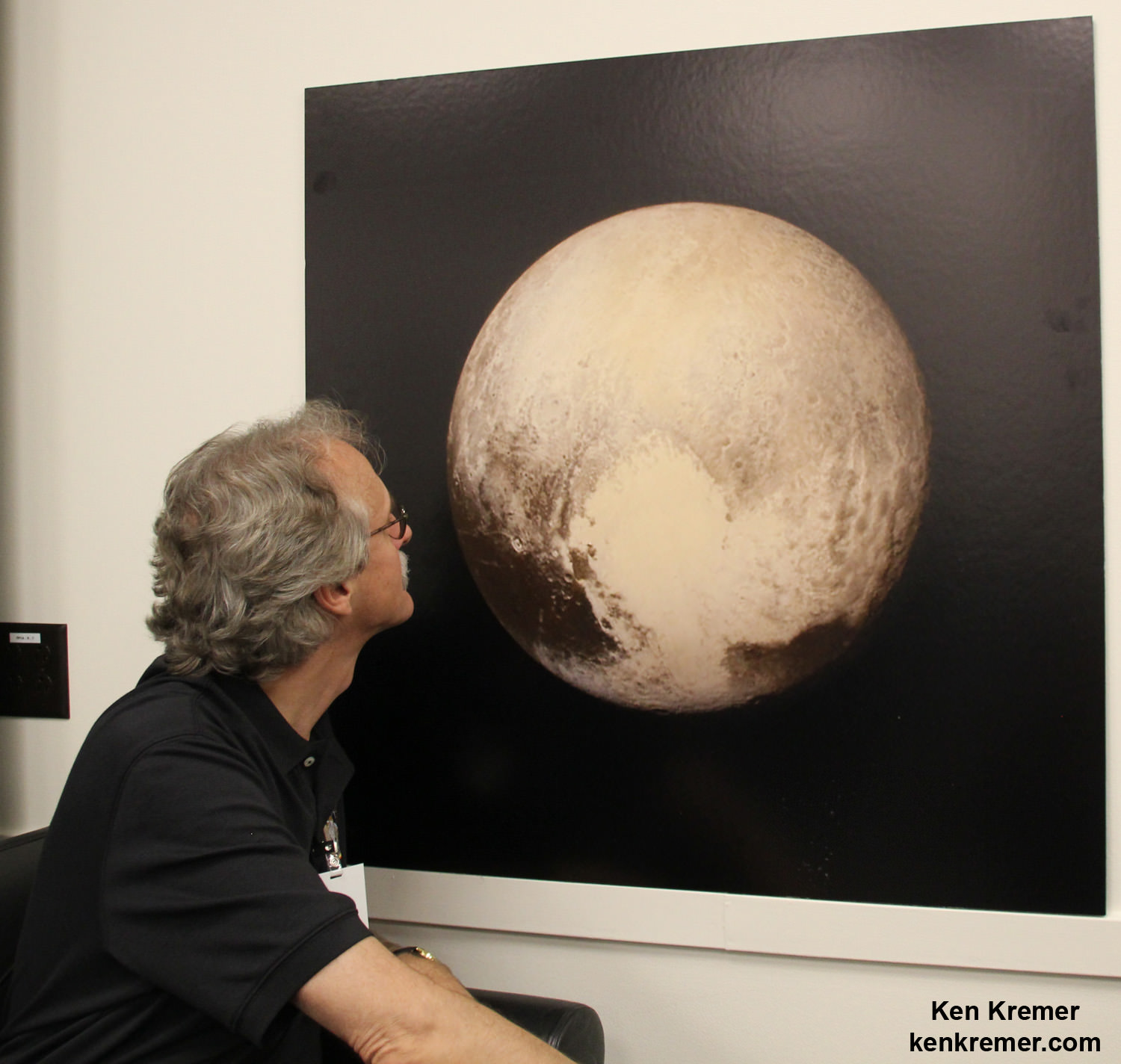
New Horizons science team co-investigator John Spencer examines print of the newest Pluto image taken on July 13, 2015 after the successful Pluto flyby. Credit: Ken Kremer/kenkremer.com
Stay tuned here for Ken’s continuing Earth and planetary science and human spaceflight news.
This new global mosaic view of Pluto was created from the latest high-resolution images to be downlinked from NASA’s New Horizons spacecraft and released on Sept. 11, 2015. The images were taken as New Horizons flew past Pluto on July 14, 2015, from a distance of 50,000 miles (80,000 kilometers). This new mosaic was stitched from over two dozen raw images captured by the LORRI imager and colorized. Annotated with informal place names. Credits: NASA/Johns Hopkins University Applied Physics Laboratory/Southwest Research Institute/Marco Di Lorenzo/Ken Kremer/kenkremer.com
Special Guests:
Maggie Scholtz (@martianmagster), who is a Mechanical Engineer working at JPL. She worked on the Curiosity Rover, primarily on the development of the drill and sampling system.
This color image of Pluto taken by NASA’s New Horizons spacecraft shows rounded and bizarrely textured mountains, informally named the Tartarus Dorsa, rise up along Pluto’s terminator and show intricate but puzzling patterns of blue-gray ridges and reddish material in between. This view, roughly 330 miles (530 kilometers) across, combines blue, red and infrared images taken by the Ralph/Multispectral Visual Imaging Camera (MVIC) on July 14, 2015, and resolves details and colors on scales as small as 0.8 miles (1.3 kilometers). Credits: NASA/JHUAPL/SWRI
Data from that priceless, once in a lifetime flyby is now trickling back to Earth.
The ‘snakeskin’ feature on Pluto’s utterly bizarre surface was unveiled to “astonished” scientists scrutinizing the latest data dump received over the past week, that included images taken by the Ralph instruments Multispectral Visual Imaging Camera (MVIC).
Features as small as 0.8 miles (1.3 kilometers) are resolved in detail.
The MVIC image stretches about 330 miles (530 kilometers) across the ‘snakeskin’ like landscape composed of rounded and bizarrely textured mountains that are informally named Tartarus Dorsa and that borders the bodies day-night terminator.
It shows intricate patterns of blue-gray ridges and reddish material in between that are puzzling researchers.
“It’s a unique and perplexing landscape stretching over hundreds of miles,” said William McKinnon, New Horizons Geology, Geophysics and Imaging (GGI) team deputy lead from Washington University in St. Louis.
“It looks more like tree bark or dragon scales than geology. This’ll really take time to figure out; maybe it’s some combination of internal tectonic forces and ice sublimation driven by Pluto’s faint sunlight.”
The Ralph/MVIC image is actually a composite of blue, red and infrared images.
The image of Tartarus Dorsa reveals a “multitude of previously unseen topographic and compositional details. It captures a vast rippling landscape of strange, aligned linear ridges that has astonished New Horizons team members,” say officials.
NASA’s New Horizons spacecraft captured this high-resolution enhanced color view of Pluto on July 14, 2015. The image combines blue, red and infrared images taken by the Ralph/Multispectral Visual Imaging Camera (MVIC). Pluto’s surface sports a remarkable range of subtle colors, enhanced in this view to a rainbow of pale blues, yellows, oranges, and deep reds. Many landforms have their own distinct colors, telling a complex geological and climatological story that scientists have only just begun to decode. The image resolves details and colors on scales as small as 0.8 miles (1.3 kilometers). The viewer is encouraged to zoom in on the image on a larger screen to fully appreciate the complexity of Pluto’s surface features. Credit: NASA/JHUAPL/SwRI
Another wider angle global view of Pluto downlinked on Sept. 19 shows a new “extended color” view of Pluto with an the extraordinarily rich color palette of the planet.
“We used MVIC’s infrared channel to extend our spectral view of Pluto,” said John Spencer, a GGI deputy lead from Southwest Research Institute (SwRI) in Boulder, Colorado.
“Pluto’s surface colors were enhanced in this view to reveal subtle details in a rainbow of pale blues, yellows, oranges, and deep reds. Many landforms have their own distinct colors, telling a wonderfully complex geological and climatological story that we have only just begun to decode.”
The image resolves details and colors on scales as small as 0.8 miles (1.3 kilometers).
High-resolution images of Pluto taken by NASA’s New Horizons spacecraft just before closest approach on July 14, 2015, reveal features as small as 270 yards (250 meters) across, from craters to faulted mountain blocks, to the textured surface of the vast basin informally called Sputnik Planum. Enhanced color has been added from the global color image. This image is about 330 miles (530 kilometers) across. For optimal viewing, zoom in on the image on a larger screen. Credits: NASA/JHUAPL/SWRI
Beyond MVIC, additional new images taken by New Horizons’ narrow-angle Long Range Reconnaissance Imager (LORRI) during the July 14 were downlinked on Sept. 20.
They focus on the Sputnik Planum ice plains on the left side of the famous heart shaped Tombaugh Regio feature and are the highest resolution yet – as seen below. The team added color based on the global MVIC map shown above.
High-resolution images of Pluto taken by NASA’s New Horizons spacecraft just before closest approach on July 14, 2015, are the sharpest images to date of Pluto’s varied terrain—revealing details down to scales of 270 meters. In this 75-mile (120-kilometer) section of the taken from a larger, high-resolution mosaic, the textured surface of the plain surrounds two isolated ice mountains. Credits: NASA/JHUAPL/SWRI
Barely 5 or 6 percent of the 50 gigabits of data captured by New Horizons has been received by ground stations back on Earth.
“With these just-downlinked images and maps, we’ve turned a new page in the study of Pluto beginning to reveal the planet at high resolution in both color and composition,” added New Horizons Principal Investigator Alan Stern, of SwRI.
“I wish Pluto’s discoverer Clyde Tombaugh had lived to see this day.”
Stern says it will take about a year for all the data to get back. Thus bountiful new discoveries are on tap.
This new global mosaic view of Pluto was created from the latest high-resolution images to be downlinked from NASA’s New Horizons spacecraft and released on Sept. 11, 2015. The images were taken as New Horizons flew past Pluto on July 14, 2015, from a distance of 50,000 miles (80,000 kilometers). This mosaic was stitched from over two dozen raw images captured by the LORRI imager and colorized. Right side mosaic comprises twelve highest resolution views of Tombaugh Regio heart shaped feature and shows objects as small as 0.5 miles (0.8 kilometers) in size. Credits: NASA/Johns Hopkins University Applied Physics Laboratory/Southwest Research Institute/ Ken Kremer/kenkremer.com/Marco Di Lorenzo
Stay tuned here for Ken’s continuing Earth and planetary science and human spaceflight news.
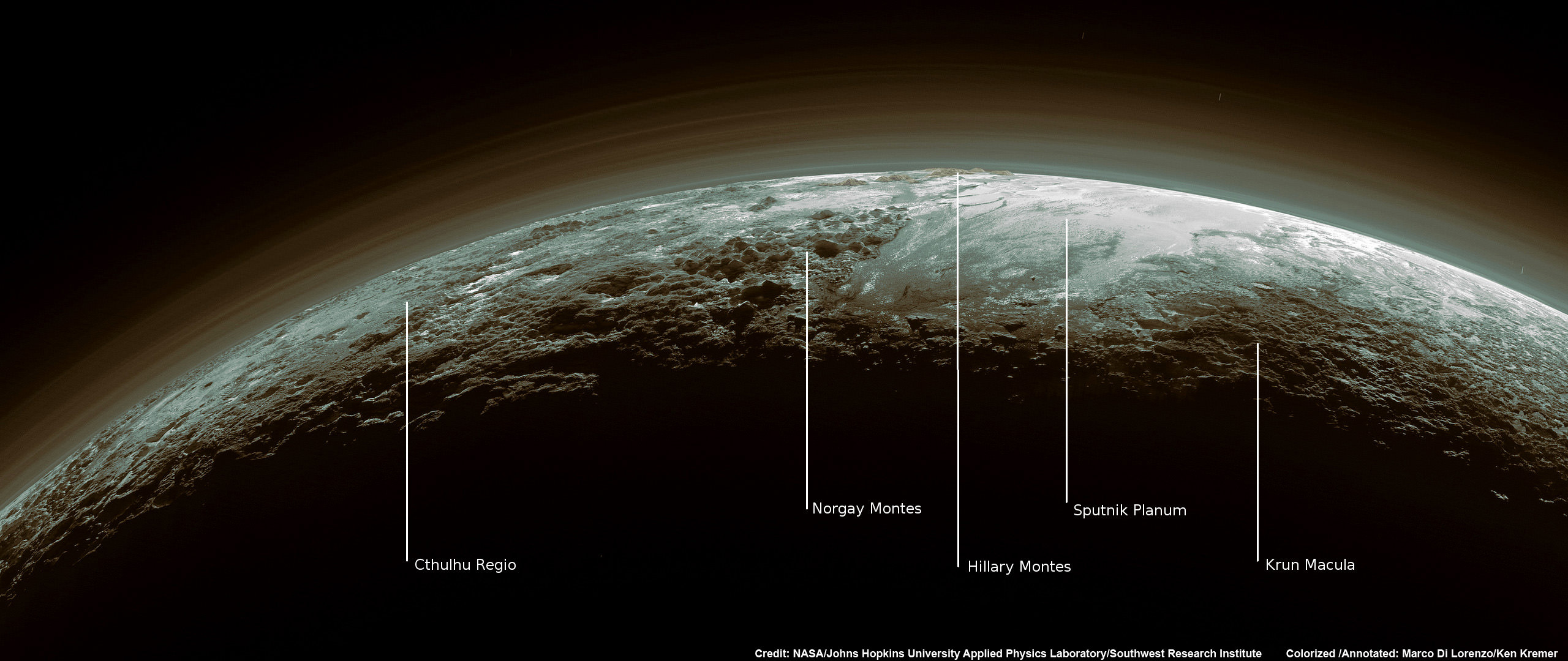
Just 15 minutes after its closest approach to Pluto on July 14, 2015, NASA’s New Horizons spacecraft looked back toward the sun and captured this near-sunset view of the rugged, icy mountains and flat ice plains extending to Pluto’s horizon – shown in this colorized rendition. The smooth expanse of the informally named icy plain Sputnik Planum (right) is flanked to the west (left) by rugged mountains up to 11,000 feet (3,500 meters) high, including the informally named Norgay Montes in the foreground and Hillary Montes on the skyline. To the right, east of Sputnik, rougher terrain is cut by apparent glaciers. The backlighting highlights more than a dozen layers of haze in Pluto’s tenuous but distended atmosphere. The image was taken from a distance of 11,000 miles (18,000 kilometers) to Pluto; the scene is 780 miles (1,250 kilometers) wide. Credit: NASA/Johns Hopkins University Applied Physics Laboratory/Southwest Research Institute. Colorized/Annotated: Marco Di Lorenzo/Ken Kremer/kenkremer.com
This new global mosaic view of Pluto was created from the latest high-resolution images to be downlinked from NASA’s New Horizons spacecraft and released on Sept. 11, 2015. The images were taken as New Horizons flew past Pluto on July 14, 2015, from a distance of 50,000 miles (80,000 kilometers). This mosaic was stitched from over two dozen raw images captured by the LORRI imager and colorized. Right side mosaic comprises twelve highest resolution views of Tombaugh Regio heart shaped feature and shows objects as small as 0.5 miles (0.8 kilometers) in size. Credits: NASA/Johns Hopkins University Applied Physics Laboratory/Southwest Research Institute/ Ken Kremer/kenkremer.com/Marco Di Lorenzo
Video caption: This animation of LORRI (Long Range Reconnaissance Imager) images begins with a low-altitude look at the informally named Norgay Montes, flies northward over the boundary between informally named Sputnik Planum and Cthulhu Regio, turns, and drifts slowly east above Pluto’s heart shaped Tombaugh Regio feature. It then rises about 10 times higher in altitude as NASA’s New Horizons flew closest to Pluto on July 14, 2015. Credit: NASA/JHUAPL/SwRI/Stuart Robbins. See additional high resolution global Pluto and Tombaugh Regio mosaics below
Imagine yourself as a once in a lifetime Plutonian tourist sailing along in a spartan spaceship and looking out the windows to breathtaking alien landscapes with cameras snapping away.
Now for the first time in human history, you can embark on a heretofore unimaginable flyover tour over Pluto – the most distant planetary system yet explored by an emissary from Earth, thanks to the team propelling NASA’s New Horizons spacecraft to the far flung reaches of our Solar System.
Just click on the video above and take the astounding aerial flyover tour above Pluto’s huge heart and the icy worlds wondrous array of tectonically active flow plains and majestic mountain ranges towering kilometers skyward to its thin hazy atmosphere.
The animation is a gift to humanity as seen from the perspective of the New Horizons probe as it flew past Pluto on July 14, 2015 at a distance of 50,000 miles (80,000 kilometers).
The new flyover video beautifully melds “art and science” – and is the brainchild of Stuart Robbins, a New Horizons research scientist at the Southwest Research Institute in Boulder, Colorado.
“I have used the latest images to produce an animation that shows what it might be like to take an aerial tour through Pluto’s thin atmosphere and soar above the surface that New Horizons explored,” Robbins explained in a blog posting.
The flyover animation is based on a stitched together mosaic of New Horizons images that were then rendered onto a sphere of Pluto. The animation and spherical mosaic were created by New Horizons team members using the initial batch of images taken by the LORRI (Long Range Reconnaissance Imager) camera and downloaded from the spacecraft as of Sept. 11, 2015.
“The mosaic …. provides an incredibly accurate portrayal of Pluto’s surface. It showcases …. the huge variety of terrain types that we see on Pluto.”
The flyover begins low over the heart shaped region of Pluto informally named Tombaugh Regio by the New Horizons team. The LORRI images at the starting point over the Norgay Montes mountain range have a resolution up to 400 meters per pixel at a altitude of only about 120 miles (200 kilometers). The resolution then changes to about 800 meters per pixel.
The animation concludes with images of approximately 2.1 kilometers per pixel as the apparent altitude increases tenfold to about 1,500 miles (2,500 kilometers) as viewers perspective changes from an up close view to one revealing Pluto’s disk rapidly growing to show about 80% of the hemisphere New Horizons flew closest to on July 14, 2015.
Here is Robbins explanation of the Plutonian terrain visible during your tourists eye view:
“Our tour starts low over the informally named Norgay Montes at a height of about 120 miles (200 kilometers). These jagged mountains rise almost 2 miles (3 kilometers) from the surrounding surface.”
“We head north over Sputnik Planum (bright area to the left) and Cthulhu Regio (dark area to the right). While Sputnik Planum is smooth at this pixel scale, it’s in marked contrast to Cthulhu Regio which has many large impact craters that indicate the Regio is much older. The differences in brightness are some of the largest natural brightness variations of any object in the solar system.”
“Our view steadily rises to a height of about 150 miles (240 kilometers) and turns to look east. From this point, we drift slowly to the east, with Pluto’s north pole to the left, Tombaugh Regio filling much of the middle of the view, and older, more cratered areas standing out in marked contrast to the younger glaciers of the “heart’s” left lobe, Sputnik Planum.”
“As we continue to fly, our flight path rises to more than 1,500 miles (2,500 kilometers) with the final view of most of the disk that New Horizons saw on July 14.”
Robbins role on the New Horizons science team is using the images “to map craters across the surfaces of Pluto and its largest moon, Charon, to understand the population of impactors from the Kuiper Belt striking Pluto and Charon.”
To see and study the whole disk of Pluto and the highest resolution view of the “heart” check out our global Pluto and Tombaugh Regio mosaics generated from raw images captured by New Horizons’ Long Range Reconnaissance Imager (LORRI) and stitched together by the image processing team of Marco Di Lorenzo and Ken Kremer.
New Horizon’s unveiled Pluto as a surprisingly vibrant and geologically active “icy world of wonders” as it barreled past the Pluto-Charon double planet system on July 14 at over 31,000 mph (49,600 kph) and collected unprecedented high resolution imagery and spectral measurements of the utterly alien worlds.
What are Pluto’s newly discovered plains and mountains composed of?
“The plains are made of nitrogen. But nitrogen is too soft a material to build mountains out of, even in Pluto’s weak gravity,” says New Horizons Principal Investigator Alan Stern of the Southwest Research Institute, Boulder, Colorado.
“So the mountains must be made of something else stronger. Rock and water ice are the two most likely possibilities. But they are most likely water ice.”
Here’s our colorized and annotated version of the recently released backlit view of Pluto taken 15 minutes after closest approach as New Horizons spacecraft looked back toward the sun and captured a near-sunset view of the rugged, icy mountains and flat ice plains extending to Pluto’s horizon.
Just 15 minutes after its closest approach to Pluto on July 14, 2015, NASA’s New Horizons spacecraft looked back toward the sun and captured this near-sunset view of the rugged, icy mountains and flat ice plains extending to Pluto’s horizon – shown in this colorized rendition. The smooth expanse of the informally named icy plain Sputnik Planum (right) is flanked to the west (left) by rugged mountains up to 11,000 feet (3,500 meters) high, including the informally named Norgay Montes in the foreground and Hillary Montes on the skyline. To the right, east of Sputnik, rougher terrain is cut by apparent glaciers. The backlighting highlights more than a dozen layers of haze in Pluto’s tenuous but distended atmosphere. The image was taken from a distance of 11,000 miles (18,000 kilometers) to Pluto; the scene is 780 miles (1,250 kilometers) wide. Credit: NASA/Johns Hopkins University Applied Physics Laboratory/Southwest Research Institute. Colorized/Annotated: Marco Di Lorenzo/Ken Kremer/kenkremer.com
Since the flyby, the team has been busy analyzing the science data returned thus far and “making some discoveries” says Stern.
“Pluto is showing us a diversity of landforms and complexity of processes that rival anything we’ve seen in the solar system.”
“If an artist had painted this Pluto before our flyby, I probably would have called it over the top — but that’s what is actually there.”
New Horizons gathered about 50 gigabits of data as it hurtled past Pluto, its largest moon Charon and four smaller moons.
New Horizons also discovered that Pluto is the biggest object in the outer solar system and thus the ‘King of the Kuiper Belt’.
The Kuiper Belt comprises the third and outermost region of worlds in our solar system.
Only about 5 to 6 percent has been downlinked to Earth so far. Stern says it will take about a year for all the data to get back.
So expect a year of endless treats and surprises from the ‘King of the Kuiper Belt’!
This new global mosaic view of Pluto was created from the latest high-resolution images to be downlinked from NASA’s New Horizons spacecraft and released on Sept. 11, 2015. The images were taken as New Horizons flew past Pluto on July 14, 2015, from a distance of 50,000 miles (80,000 kilometers). This new mosaic was stitched from over two dozen raw images captured by the LORRI imager and colorized. Credits: NASA/Johns Hopkins University Applied Physics Laboratory/Southwest Research Institute/Marco Di Lorenzo/Ken Kremer/kenkremer.com
Watch for Ken’s continuing coverage of the Pluto flyby. He was onsite reporting live on the flyby and media briefings for Universe Today from the Johns Hopkins University Applied Physics Laboratory (APL), in Laurel, Md.
Stay tuned here for Ken’s continuing Earth and planetary science and human spaceflight news.