DARPA Moving Ahead with Building Zombie Frankensatellites

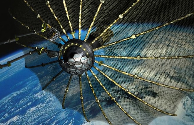
Caption: Phoenix satellite concept. Credit: DARPA

“Alien” meets “Bride of Frankenstein” and “Night of the Living Dead?” Straight from a possible sci-fi/horror movie mashup, the Defense Advanced Research Projects Agency (DARPA) wants to harvest components from dead, non-working “zombie” satellites to build new ones in space, all done remotely via a grasping, mechanical arm.

The agency would like to have the first keystone mission of what is called the Phoenix Program up and running by 2015, and they recently announced that several companies and NASA’s Jet Propulsion Lab have won a share of a $36 million contract award to help develop the technology to assemble new satellites from old, dead ones.

This project would harvest larger working parts, such as antennas and solar arrays from satellites that have otherwise have failed and are still in geosynchronous orbit, 35,000 kilometers (22,000 miles) above Earth. DARPA envisions robotically removing and re-using these parts from decommissioned satellites by developing a new class of very small ‘satlets,’ similar to nano satellites, which could “ride along” other commercial satellite launches, greatly reducing launch costs, DARPA says.

The satlets would attach themselves to the antenna or solar array of a non-functional satellite, remove the part and move it to a different orbit where a satellite servicing spacecraft is waiting to robotically operate on and build a new satellite while in orbit. The servicing satellite would be equipped with grasping mechanical arms for removing the satlets and components. These unique space tools are what needs to be developed for the program.

The robotic arms/grappling tools will be controlled remotely from Earth. The pieces will then be reconfigured into a new free-flying space system and operated independently to demonstrate the concept of space re-use.

DARPA is interested in building communication satellites to provide 24-hour communication capabilities for the military.

“Today, when a communication satellite fails, it usually means the expensive prospect of having to launch a brand new replacement communication satellite,” DARPA’s Phoenix Program webpage says. “The goal of the Phoenix program is to develop and demonstrate technologies to cooperatively harvest and re-use valuable components from retired, nonworking satellites in GEO and demonstrate the ability to create new space systems at greatly reduced cost.”

Among the companies that have a share in creating the components needed to make Phoenix a reality are Altius Space Machines, Space Systems/Loral; Intelsat; MacDonald, Dettwiler and Associates; Honeybee Robotics; and JPL.

Some of the technology DARPA expects to be built for the Phoenix program include:

Radiation tolerant micro-electronics and memory storage
Industrial robotics end effectors and tool changeout mechanisms and techniques
Computer-assisted medical robotics micro-surgical tele-presence, tools and imaging
Remote imaging/vision technologies

Watch DARPA’s video on the Phoenix Program:

For more information, see the DARPA Phoenix webpage.

Virgin Galactic Announces New Satellite Launcher

Caption: Richard Branson at the Farnborough International Airshow showing a model of LauncherOne. Credit: Virgin Galactic.

Virgin Galactic’s latest venture is launching small satellites with a new, more affordable launching system called LauncherOne. “The pieces are all in place to transform the business of satellite launch, which will open up space to everyone,” said the founder of Virgin Galactic, Richard Branson. “This new vehicle will change the whole satellite industry and space-based science research.”

LauncherOne is much like the Pegasus system, operated by Orbital Sciences Corporation, which launches a rocket from an aircraft, as was done with NASA’s NuSTAR X-ray observatory. LauncherOne will be attached to the WhiteKnight plane, the mothership for SpaceShipTwo, Virgin’s commercial suborbital passenger ship.
LauncherOne could be used for smaller Earth observation and communications satellites.

Virgin Galactic has hinted previously that they were working on a rocket to put spacecraft into orbit, but they have been focusing on SpaceShipTwo. Branson announced the new launcher at the Farnborough International Airshow in the UK today.

“Small satellite launch is an area ripe for disruption,” said Virgin Galactic CEO George Whitesides. “Miniaturized satellite components and constrained budgets are driving commercial clients, academic users and government agencies all to clamor for an affordable, dedicated launch vehicle. Now,…we’re prepared to fill that void by bringing LauncherOne to market.”

Initial information about LauncherOne is that it would use a two-stage rocket powered by liquid oxygen and kerosene.

It would be capable of launching payloads of up 225kg (500lb) into low-Earth orbits, and for a price below $10 million.

“The cost of putting a satellite into space before Virgin Galactic was around $30-40 million,” Branson said. “We’ll be able to do it for under $10 million, opening up space to thousands of new groups, universities and research programs.”

LauncherOne will be built in California, with test flights starting in 2015 and commercial operations starting in 2016.

“Virgin Galactic’s goal is to revolutionize the way we get to space,” Branson said. “I’m immensely proud of what we have already achieved as we draw near to regular suborbital flights on SpaceShipTwo. Now, LauncherOne is bringing the price of satellite launch into the realm of affordability for innovators everywhere, from start-ups and schools to established companies and national space agencies. It will be a critical new tool for the global research community, enabling us all to learn about our home planet more quickly and affordably.”

Branson said he already has people lined up to book the new launcher. “Even before this official launch we have the largest order book of any new launch vehicle ever,” he said on the Virgin blog.

Sources: Virgin, BBC

Powerful “Derecho” Storms as Seen from Space

The powerful windstorms that swept across the US last week was captured by several different satellites. This type of storm, called a derecho, moved from Illinois to the Mid-Atlantic states on June 29, and the movie from NOAA’s GOES-13 satellite shows the storms’ sudden expansion and speed. The storms left a more than 1,000-km (700-mile) trail of destruction across the Midwest and mid-Atlantic, cutting power to millions and killing thirteen people.

A derecho (pronounced “deh-REY-cho”) is not your average, ordinary local summer thunderstorm. These are widespread, long-lived but rare wind storms that are usually associated with a band of rapidly moving showers or thunderstorms. Damage from a derecho is usually in one direction along a relatively straight track. By definition an event is classified a derecho if the wind damage swath extends more than 400 km (240 miles) and includes wind gusts of at least 93 km/h (58 mph) or greater along most of its length.

These storms occur in the United States during the late spring and summer, with more than three quarters occurring between April and August.

The movie begins on June 28 at 15:15 UTC (11:15 a.m. EDT) and ends on June 30, 2012 at 16:01 UTC (12:01 p.m. EDT). In the animation, the derecho’s clouds appear as a line in the upper Midwest on June 29 at 14:32. By 16:02 UTC, they appear as a rounded area south of Lake Michigan. By 21:32, the area of the derecho’s clouds were near Lake Erie and over Ohio expanding as the system track southeast. By 06:30 UTC, the size appears to have almost doubled as the derecho moves over West Virginia, Maryland, Pennsylvania and Virginia. At 02:32 UTC on June 30 (10:32 p.m. EDT), the Derecho was over the mid-Atlantic bringing a 160 km (100 mile) line of severe storms and wind gusts as high as 144 km/h (90 mph) to the region.

“It is interesting how the process is a self-sustaining process that is fed by a combination of atmospheric factors that all have to be in place at the same time,” said Joe Witte, a meteorologist in Climate Change Communication at George Mason University, Va. and a consultant to NASA. “That is why they are relatively rare: not all the elements line up that often.”

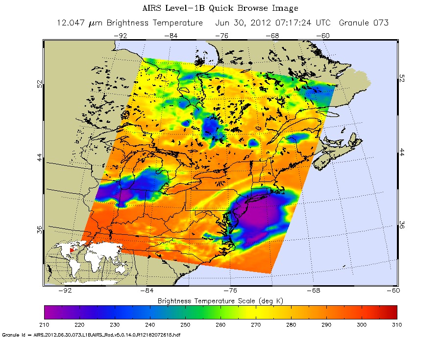
NASA’s Aqua satellite flew over the derecho on June 29 and June 30, using the Atmospheric Infrared Sounder instrument (AIRS) onboard to capture infrared imagery of the event, as seen above.

“The AIRS infrared image shows the high near-surface atmospheric temperatures blanketing the South and Midwestern U.S., approaching 98 degrees Fahrenheit,” said Ed Olsen of the AIRS Team at NASA’s Jet Propulsion Laboratory.

The AIRS images for June 30 show areas of intense convection centered off the New Jersey coast and another, less intense, system over Iowa-Indiana-Ohio. The area off the New Jersey coast is no longer a rapidly moving linear front. The near-surface atmospheric temperatures over the South and Midwest had decreased by 10 to 15 Fahrenheit in most areas,” Olsen said.

NASA’s Suomi National Polar-orbiting Partnership satellite (NPP) captured night-time images on June 28 and June 30, that reflected the massive blackouts that occurred after the derecho swept through the mid-Atlantic states. You can see the comparison images here at NASA’s Earth Observatory website.

The mechanics of a derecho go like this: The downburst mentioned by Witte, above, occurs when cold air in the upper atmosphere is cooled more by the evaporation of some of the rain and melting of the frozen precipitation pushed up into the high levels of the towering cumulonimbus (thunderclouds). That cold air becomes much denser than the surrounding air and literally falls to the ground, accelerating like any other falling body.

“The huge blob of very cold air from the upper atmosphere has a higher forward wind speed since it is high in the atmosphere,” Witte said. “This gives the ‘blob’ great forward momentum. Add that speed to the falling speed and the result is a very powerful forward moving surface wind.”

The process of a derecho can become self-sustaining as hot and humid air is forced upward by the gust front and develops more (reinforcing) towering clouds. If there is a rear low level jet stream, there is nothing to stop the repeating process.

You can find out more information about derechos at this NOAA page.

Source: NASA

The May 2012 Annular Eclipse as Seen From Space

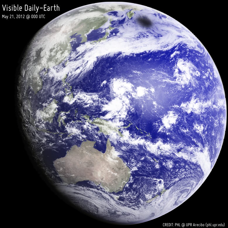
A shadow over Earth near the maximum during the Annular Solar Eclipse of May 20-21, 2012. Credit: Planetary Habitability Laboratory at UPR Arecibo, NASA, EUMETSAT, NERC Satellite Receiving Station, University of Dundee.

[/caption]

Here’s a few unique vantage points of seeing the annular solar eclipse on May 20/21 2012. Above, one of the geostationary satellites called MTSAT (Multi-Functional Transport Satellite) built by Japan was able to capture the shadow over Earth near the maximum of the eclipse of May 20-21, 2012. It’s rather amazing how small the shadow is! “This image was generated during a color test of our Visible Daily-Earth project,” wrote Abel Mendez Torres on the PHL@UPR Arecibo website “and was taken by the MTSAT on May 21, 2012 @ 000 UTC (May 20, 2012 @ 8:00 PM EDT). Color correction was based on NASA Visible Earth datasets.” The Planetary Habitability Laboratory (PHL) is a research and educational virtual laboratory that studies of the habitability of Earth, the Solar System, and extrasolar planets, and @ProfAbelMendez is a very interesting person to follow on Twitter.

Below are a couple of videos: even though you are not supposed to look directly at the Sun during an eclipse, the PROBA-2 satellite did with an awesome result, and astronaut Don Pettit’s exceptional view of the eclipse from the International Space Station, as well as a view from the Hinode and Terra satellites:

ESA’s space weather microsatellite Proba-2 observed the solar eclipse on the evening of May 20, 2012. It passed through the Moon’s shadow a total of four times, imaging a sequence of partial solar eclipses in the process. The first contact was made on Sunday May 20 at 21:09 GMT. The last contact finished at 03:04 GMT.

Don Pettit’s view:

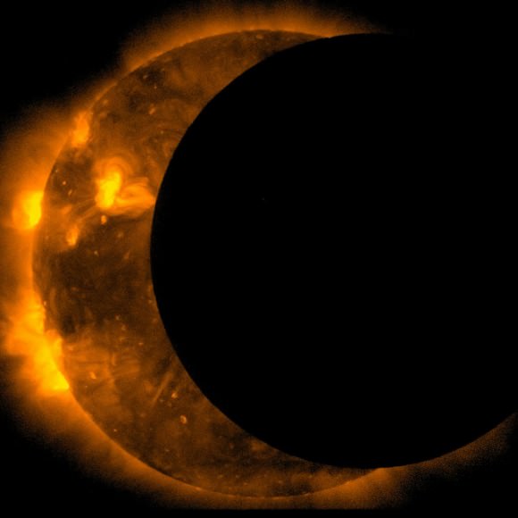
The joint JAXA/NASA Hinode mission captured this images of an annular eclipse of the Sun on May 20, 2012. Credit: Hinode/JAXA/NASA

Also, the JAXA/NASA Hinode mission captured this video of the eclipse.

Here’s a view of the eclipse over the North Pacific Ocean as see by the Terra satellite:

Credit: NASA/GSFC/Jeff Schmaltz/MODIS Land Rapid Response Team

The Moderate Resolution Imaging Spectroradiometer (MODIS) aboard the Terra satellite captured this true-color image of the annular solar eclipse over the North Pacific Ocean on May 20, 2012. Credit: NASA/GSFC/Jeff Schmaltz/MODIS Land Rapid Response Team

Make sure you check out our gallery of eclipse images from around the world, too!

View from Orbit of a Huge White Sands Dust Storm

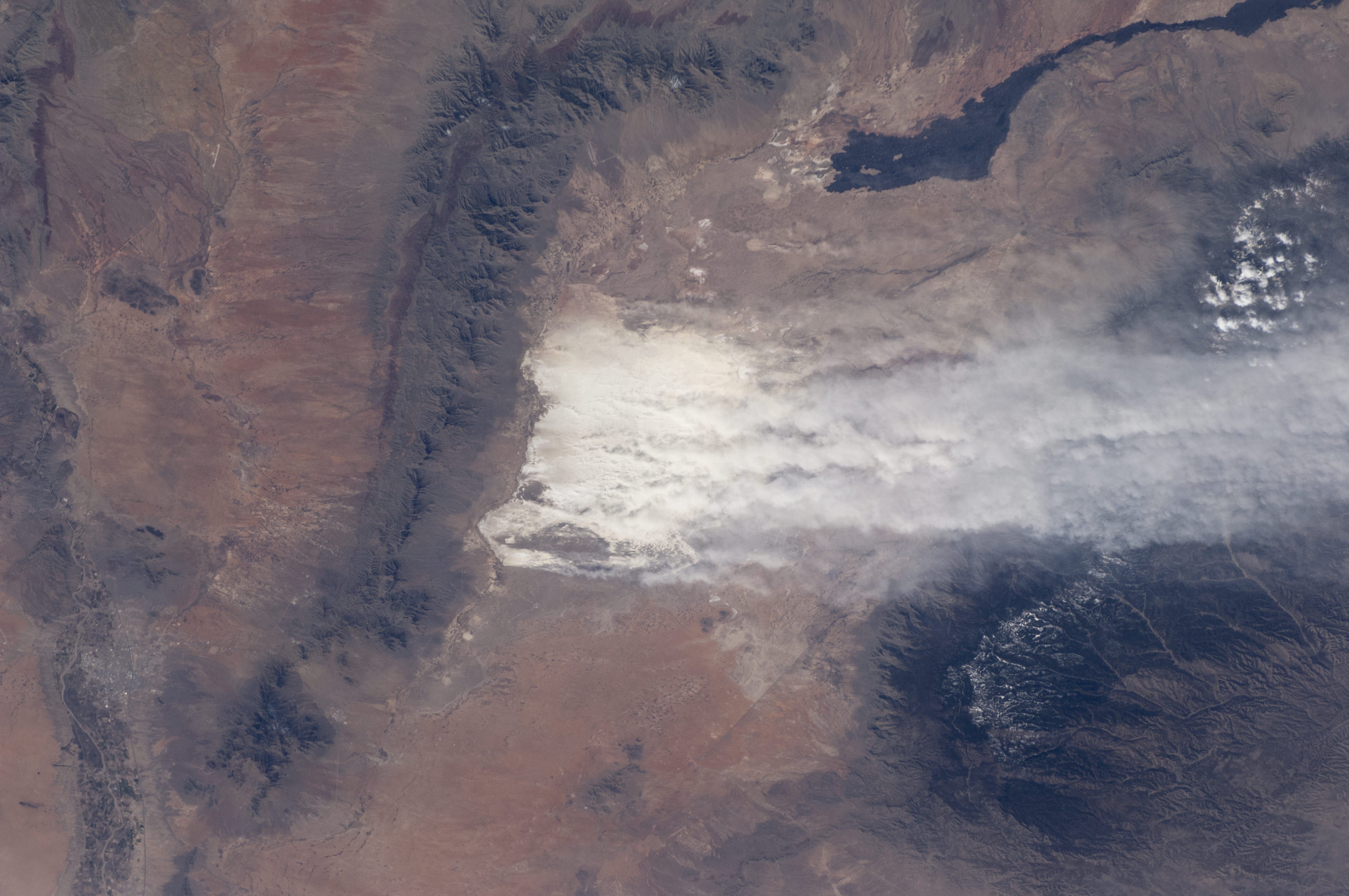
Driven by southwesterly winter winds, dust from the White Sands dune field in New Mexico rises thousands of feet from the valley floor and drifts over the snowy peaks of the Sacramento Mountains. Credit: NASA

[/caption]

It’s clear from this image of why a region in New Mexico, USA is called ‘White Sands.’ The dust plumes in this photograph taken by an astronaut on board the International Space Station show a dust storm in the White Sands National Monument. But this is a huge dust storm. The white dust plumes stretch across more than 120 kilometers (74 miles).

Caused by winds that channel the dust through a low point in the mountains, the vigorous winds are lifting dust particles from the valley floor to more than 1200 meters over the mountains. The Moderate Resolution Imaging Spectroradiometer (MODIS) on NASA’s Aqua satellite also captured a wider, regional view of the same storm on the same day.

The sand dunes of this national monument are white because they are composed of gypsum, a relatively rare dune-forming mineral. The dunes’ brilliance, especially contrasted against the nearby dark mountain slopes, makes them easily identifiable to orbiting astronauts. The white speck of the dunes was even visible to the Apollo astronaut crews looking back at Earth on the way to the Moon.

Source: NASA Earth Observatory

ESA’s Ailing Envisat Imaged by Another Earth Orbiting Satellite

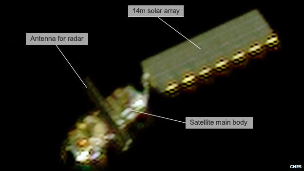
France's Pleiades Earth observation satellite captured this image of the silent Envisat satellite on April 15, 2012, from a distance of about 100 km. Credit: CNES

[/caption]

ESA’s mysteriously silent Envisat Earth observing satellite has been observed and imaged by another satellite in space. France’s space agency (CNES) pulled off an on-orbit coup, using their high-resolution Pleiades satellite to take a picture of Envisat from about 100 km. The good news is that engineers were able to determine Envisat is fully intact and has not been obviously damaged by impacts by space debris or meteoroids. The massive Envisat fell silent on April 8 after 10 years of service – twice its designed lifetime — providing high quality images and data of our changing Earth.

“We are really grateful to CNES for offering to acquire images of Envisat using their Pleiades and Spot satellites,” said Volker Liebig, ESA’s Director of Earth Observation Programs. “Additional observations being acquired across the globe show how the international space community has come together to track this veteran satellite.”

Previous optical, radar and laser observations of Envisat show it is still in a stable orbit. However, engineers have not even been able to determine if the satellite is in ‘safe mode’ or if it has just gone dead. They say knowing this would be a starting point for revival and the recovery team is drawing on every information source available. If it is in safe mode, it may be possible to re-establish communications.

CNES was able to rotate the Pleiades satellite to capture images of Envisat. These images are being used to determine the orientation of Envisat’s solar panel – the satellite’s power source – to see if it is in a good position to generate power.

Envisat has been helping researchers examine our planet, completing more than 50,000 orbits and returned thousands of images, as well as a wealth of data about the land, oceans and atmosphere.

Source: ESA

Earth’s Van Gogh Oceans

I was traveling the day this video was released, so missed posting it earlier. If you haven’t seen it yet, this animation of ocean surface currents is just mesmerizing. It shows ocean currents from June 2005 to December 2007, created with data from NASA satellites. In the video you can see how bigger currents like the Gulf Stream in the Atlantic Ocean and the Kuroshio in the Pacific carry warm waters across thousands of kilometers at speeds greater than six kilometers per hour 4 mph), as well as seeing how thousands of other ocean create slow-moving, circular pools called eddies. The entire visualization is reminiscent of Vincent Van Gogh’s “Starry Night” painting.
Continue reading “Earth’s Van Gogh Oceans”

Blue Marble 2012: Amazing High Definition Image of Earth

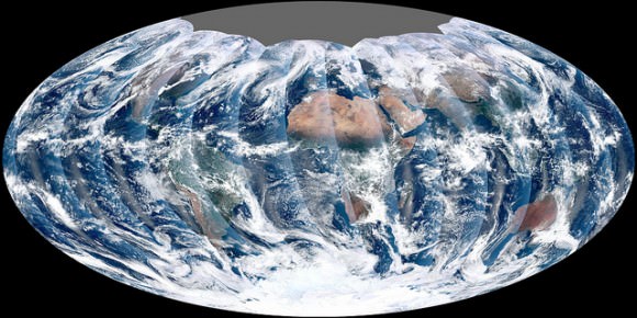
A 'Blue Marble' image of the Earth taken from the VIIRS instrument aboard NASA's most recently launched Earth-observing satellite - Suomi NPP. This composite image uses a number of swaths of the Earth's surface taken on January 4, 2012. Credit: NASA/NOAA/GSFC/Suomi NPP/VIIRS/Norman Kuring.

[/caption]

A new high-definition version of the ‘Blue Marble’ has been taken from the newest Earth observation satellite. The just-renamed Suomi NPP satellite took numerous images on January 4, 2012 and this composite image was created from several “swaths” of Earth. It is a stunningly beautiful look at our home planet, with the largest versions of the image showing about 1.6 km (1 mile) per pixel. This Sun-synchronous Earth-orbiting satellite is 824 kilometers (512 miles) above Earth, and it gets a complete view of our planet every day. It is the first of a new generation of satellites that will observe many facets of how our Earth may be changing.

Originally launched as the National Polar-orbiting Operational Environmental Satellite System Preparatory Project (NPP), it was just renamed ‘Suomi NPP’ on to honor a pioneer in the use of satellites, the late Verner E. Suomi.

See below for an image showing these “swaths” from global images taken on November 24, 2011.

The Suomi NPP satellite gets a complete view of our planet every day. This image uses 20 orbital ‘swaths’ from November 24, 2011, and is the first complete global image from the VIIRS instrument. Credit: NASA Earth Observatory.

These images were taken with the The Visible/Infrared Imager Radiometer Suite or VIIRS instrument aboard Suomi NPP.

VIIRS images the surface in long wedges measuring 3,000 kilometers (1,900 miles) across. The swaths from each successive orbit overlap one another, so that at the end of the day, the sensor has a complete view of the globe. The Arctic is missing because it is too dark to view in visible light during the winter.

The NPP satellite was placed in a Sun-synchronous orbit, so its path takes the satellite over the equator at the same local (ground) time in every orbit. This orbit allows the satellite to maintain the same angle between the Earth and the Sun so that all images have similar lighting. This consistent angle is important because it allows scientists to compare images from year to year without worrying about extreme changes in shadows and lighting.

Suomi NPP is carrying five instruments on board, and the biggest and most important instrument is VIIRS.

Unfortunately, an anomaly has been discovered in the instrument. During the checkout phase after it launched in October 2011, engineers detected a larger than expected decrease in sensor sensitivity in four of VIIRS’s near-infrared and visible channels.

An analysis revealed an anomalous material on the surface of the mirror, and further investigation on the ground discovered a non-standard process that occurred during the mirror coating as a potential source of tungsten oxide contamination on the VIIRS mirrors. Tungsten oxides could cause the surface of the mirror to darken.

This evidence suggests that the cause of the contamination is limited to the VIIRS instrument, and is not a concern for other NPP instruments. Officials from NPP said that while this problem is likely irreversible, the darkening of the VIIRS mirror caused by the contamination is expected to reach a plateau and remain at that level for the life of the mission. Although testing on this issue is continuing, NPP mission managers expect this plateau to still provide sufficient margins to allow VIIRS to meet its design requirements.

Still, the images have been spectacular so far from Suomi NPP and we look forward to more high definition views of our Blue Marble.

See the complete set of images from this spacecraft on their Flickr site.

More info on the Suomi NPP

Clear Satellite View of Earth’s Newest Island

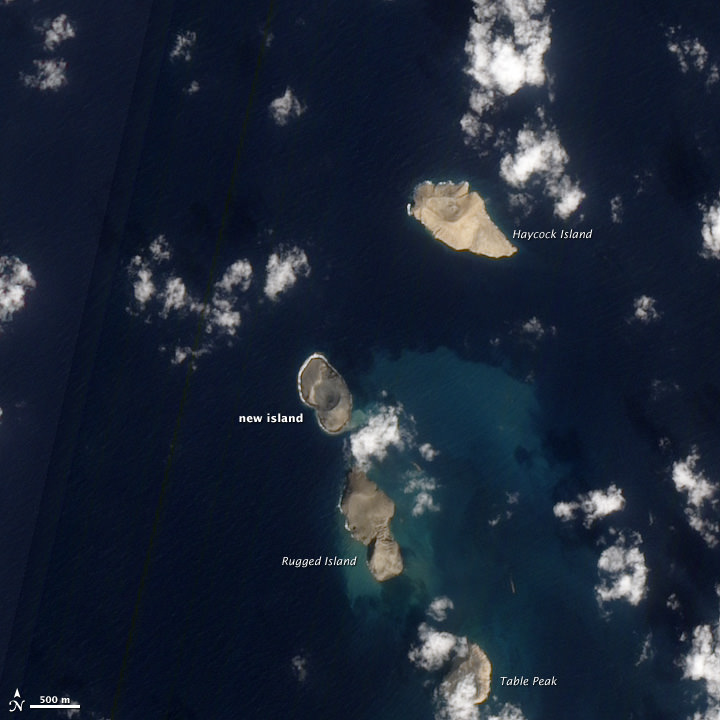
Satellite view from the Advanced Land Imager on the Earth Observer 1, showing a brand new volcanic island in the Red Sea. Credit: NASA

[/caption]

Want to get away from it all? Here’s the newest deserted island on Earth. In late December, we reported on a volcanic eruption in the Red Sea that appeared to have created a brand new island. The eruption has now stopped and on January 15, 2012 the Advanced Land Imager on the Earth Observer-1 satellite captured a clear, cloud- and volcanic plume-free view of this newly formed land mass. The new island is part of the Zubair Islands, located about 60 kilometers (40 miles) off the coast of Yemen. The new island and its older family members poke above the sea surface, rising from a shield volcano. This region is part of the Red Sea Rift where the African and Arabian tectonic plates pull apart and new ocean crust regularly forms.

If you want to visit, just watch out for hot lava pits and almost certain future eruptions.


Source: NASA Earth Observatory

As Seen From Space: Beautiful Swirling Phytoplankton Blooms

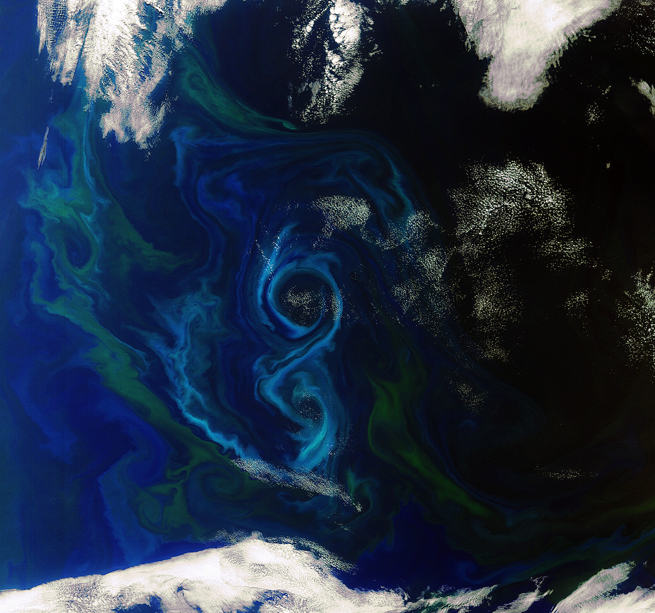
A phytoplankton bloom swirls a figure-8 in the South Atlantic Ocean. Credit: ESA, Envisat

[/caption]

One of the orbiting windows to our world, an Earth-observing satellite named Envisat, took this image in early December 2011 showing a phytoplankton bloom swirling into a figure-8 in the South Atlantic Ocean about 600 km east of the Falkland Islands. The European Space Agency says that since the phytoplankton are sensitive to environmental changes, it is important to monitor and model them for climate change calculations and to identify potentially harmful blooms. Sensors on the satellites can monitor these algal blooms and make an initial identification of its species and toxicity.

Blooms like this are common in the spring and summer, and it is currently summer in the southern hemisphere.

These microscopic organisms are the base of the marine food chain, and play a huge role in the removal of carbon dioxide from the atmosphere and the production of oxygen in the oceans. Besides being beautiful to see from space, phytoplankton help regulate the carbon cycle, and are important to the global climate system.

Source: ESA