As Seen From Space: Volcanic Eruption Creates New Island in the Red Sea

The Advanced Land Imager (ALI) on NASA’s Earth Observing-1 (EO-1) satellite captured this high-resolution, natural-color images on December 23, 2011 showing an island being formed in the Red Sea. Credit: NASA

[/caption]

Looking for some new lake-front property? Here’s the newest available on the planet. Volcanic activity in the Red Sea that started in mid-December has created what looks like a new island. The Advanced Land Imager (ALI) on NASA’s Earth Observing-1 (EO-1) satellite captured a high-resolution, natural-color image on December 23, 2011 showing an apparent island where previously there was none. Here, a thick plume of volcanic ash still rises from the new island.

See below for an image from 2007 of the same region.
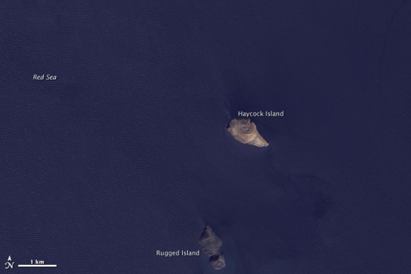
Satellite image of the same region from October 24, 2007. Credit: NASA

According to the NASA Earth Observatory website, the volcanic activity occurred along the Zubair Group, a collection of small islands off the west coast of Yemen. The islands poke above the sea surface, rising from a shield volcano. This region is part of the Red Sea Rift where the African and Arabian tectonic plates pull apart and new ocean crust regularly forms.

According to news reports, fishermen witnessed lava fountains reaching up to 30 meters (90 feet) tall on December 19.

Source: NASA Earth Observatory

Soyuz Rocket Crashes With Satellite on Board

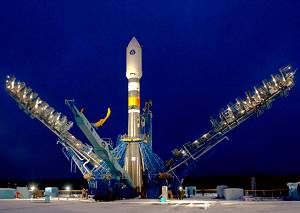
A Soyuz 2-1b rocket that launched successfully on November 27, 2011; a similar rocket failed on Dec. 23, 2011. Credit: Space Launch Report

[/caption]

A day of highs and lows for the Russian space program: while the Soyuz TMA-03M capsule docked safely at the International Space Station, a Soyuz-2 rocket carrying a communications satellite failed shortly after launch from the Plesetsk spaceport. Reports say the Meridian satellite, which can be used by the military or for civilian purposes, did not reach orbit and crashed near the city of Tobolsk in Siberia, about 2,300 km from Moscow. A combustion chamber burn-through is suspected in today’s launch, another failure in what is becoming an alarmingly long list of problems for the Russian space program.

Roscosmos director Vladimir Popovkin admitted that Russian spaceflight is “in crisis” after today’s launch failure.

An update from RussianSpaceweb.com says an analysis of available telemetry on the fuel line pressure before the entrance to the engine’s injection system indicated a possible wall bulging of the combustion chamber No. 1, leading to its burn through and a catastrophic fuel leak. (RD-0124 engine has four combustion chambers).

The Interfax news agency reported the Meridian failure could delay the launch of Progress cargo craft to the ISS, scheduled for January.

Today’s rocket failure was a Soyuz-2.1b, the latest version of the rocket that has been in service in various forms since the 1960s.

In August, a Soyuz-U rocket failed carrying a Progress resupply ship; three Glonass navigation system satellites launched in December 2010 veered off course and crashed into the Pacific Ocean; and the Phobos-Grunt probe, which launched in November is currently stuck in Earth orbit and will likely re-enter and crash after its booster failed, and communications with the spacecraft haven’t been permanently established.

The next Soyuz launch, scheduled for December 26 from the Baikonur Cosmodrome may also be delayed. This flight is intended to put six communications satellites in orbit.

Satellite Captures Unusual “Cloud Streets”

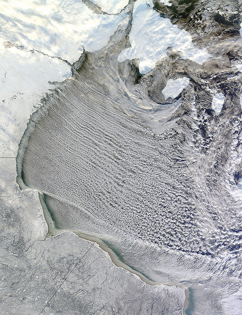
NASA' Terra satellite captured cloud streets in Hudson Bay, Canada on November 20, 2011 at 12:25 p.m. EST (17:25 UTC). Credit: NASA

[/caption]

I love looking at unusual cloud formations, and these have to be some of the most intriguing. These long, horizontal rolls of clouds are called “cloud streets” and NASA’s Terra satellite had a “drive by” of these clouds, observing them over Hudson Bay, Canada on November 20, 2011 at 12:25 p.m. EST (17:25 UTC). These rows of clouds stretch from northwest to southeast over the Hudson Bay.

Cloud streets are long lines or bands of cumulus clouds that usually form within the lower one to three kilometers of the atmosphere, and come from eddies in the atmosphere.

According to NASA’s Earth Observatory and the Goddard Space Flight Center Flickr page, cloud streets form when cold air blows over warmer waters, while a warmer air layer—or temperature inversion—rests over top of both. The comparatively warm water of Hudson Bay gives up heat and moisture to the cold air mass above, and columns of heated air—thermals—naturally rise through the atmosphere. As they hit the temperature inversion like a lid, the air rolls over like the circulation in a pot of boiling water. The water in the warm air cools and condenses into flat-bottomed, fluffy-topped cumulus clouds that line up parallel to the wind.

Hudson Bay is a large body of saltwater located in northeastern Canada. Also in the image, are several snow-covered islands in Hudson Bay. The larger island to the north is South Hampton Island, and the smaller island east is Coats Island, and further east is Mansel Island.

Satellite Image of the ‘Snowtober’ Storm

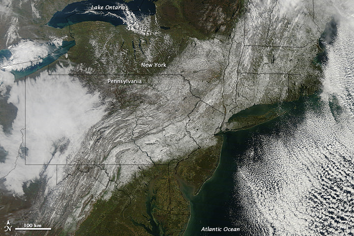
The 'Snowtober' storm in the Northeastern US, as seen by the The Moderate Resolution Imaging Spectroradiometer (MODIS) on NASA’s Terra satellite. Credit: NASA

[/caption]

An unusual October storm dumped wet heavy snow across much of the Northeast US over the weekend, as much as 32 inches (81 centimeters) in some areas. Nicknamed “Snowtober,” the storm left as many as 3 million people without power at the snowstorm’s peak, and was blamed for the deaths of at least 10 people. In this images from the Moderate Resolution Imaging Spectroradiometer (MODIS) on NASA’s Terra satellite, a swath of snow sweeps from West Virginia northeastward to Maine, as seen on Oct. 30, 2011. Clouds hover east and west of the snow, blocking the satellite sensor’s view of western Pennsylvania and parts of the Atlantic Ocean.

The storm broke snowfall-total records in many cities, with strong winds and heavy tree damage as the heavy snow easily clung to trees which still had their leaves, snapping branches and power lines.

Source: NASA Earth Obseratory

NASA’s New Climate and Weather Satellite Launches

The National Polar-orbiting Operational Environmental Satellite System Preparatory Project, or NPP, launched successfully on a Delta 2 rocket early today at at 5:48 a.m. EDT 09:48 GMT (or precisely at 2:48:01.828 a.m. PDT, according to NASA’s Twitter feed). The next generation satellite will measure both global climate changes and key weather variables, as well as test new technologies for future Earth observing satellites.

The spacecraft has also successfully separated and is now in orbit. The separation video is below.

Continue reading “NASA’s New Climate and Weather Satellite Launches”

Next Generation Climate and Weather Satellite Ready for Friday Launch

A new satellite that will test key technologies and instruments for the next generation of climate and weather-monitoring satellites is scheduled to launch on Friday, Oct. 28, 2011. The NPOESS Preparatory Project (NPP) mission has a planned liftoff from Vandenberg Air Force Base in California at 5:48 a.m. EDT/2:48 a.m. PDT.

“This is the first mission designed to provide observations for both weather forecasters and climate researchers and will provide data that is critical to climate research,” said Jim Gleason, NPP project scientist during a news briefing last week.
Continue reading “Next Generation Climate and Weather Satellite Ready for Friday Launch”

ROSAT’s Crash Site Determined

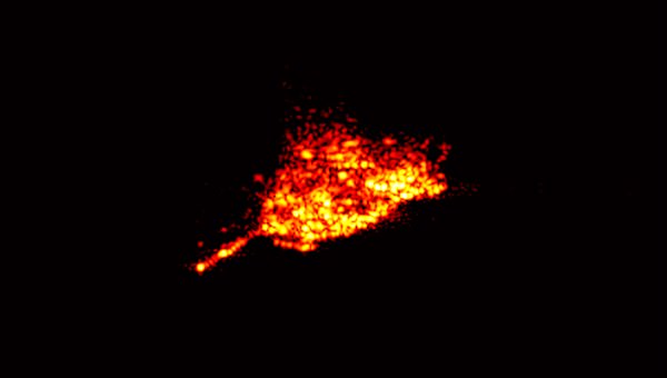
A few days before re-entering Earth's atmosphere, the German X-ray research satellite ROSAT was targeted by the Tracking and Imaging RAdar (TIRA) at the Fraunhofer Institute for High Frequency Physics and Radar Techniques in Wachtberg, near Bonn, which is unique in Europe. TIRA is part of a global network of monitoring stations that collected data about ROSAT. From this data, the orbit was determined and images were produced. This example, acquired on 20 October 2011, clearly shows the antenna mast of the satellite. Credit: Fraunhofer FHR.

[/caption]

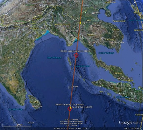
The German Aerospace Center (DLR) has identified the ROSAT’s satellite final resting place as the Bay of Bengal, off South Asia. The minivan-sized satellite re-entered the atmosphere at 0150 GMT on Sunday, October 23, 2011 (9:50 p.m. EDT on Oct. 22) and any pieces of the 21-year old satellite that survived the fiery trip likely crashed into the water. However, the ROSAT_Re-entry Twitter feed reports there is still some ambiguity, and re-entry likely took place sometime between 01:50 and 01:51, with error bar of plus or minus 7 minutes. That could make a huge difference in where debris landed. (Updated with new map, below.)

No sightings of any debris have been reported. Most of ROSAT’s parts were expected to burn up in the atmosphere, but up to 30 fragments weighing a total of 1.87 tons (1.7 metric tons) may have crashed.

Map posted by ROSAT_Reentry Twitter feed, which indicated locations on re-entry path, +/- 7 mins. Still ambiguity between 01:50 and 01:51 locations

The Bay of Bengal is located between India and Myanmar.

Yesterday, some estimations put the satellite as possibly re-entering over Northern Thailand, but again, no debris was reported. DLR now says the more precise determination of the time and location of re-entry was based on the evaluation of data provided by international partners, including the USA’s Space Command.

“With the re-entry of ROSAT, one of the most successful German scientific space missions has been brought to its ultimate conclusion. The dedication of all those involved at DLR and our national and international partners was exemplary; they are all deserving of my sincere thank you,” said Johann-Dietrich Wörner, Chairman of the Deutsches Zentrum für Luft- und Raumfahrt (DLR) Executive Board.

Source: DLR

ROSAT Satellite has Re-Entered; No Reports of Debris

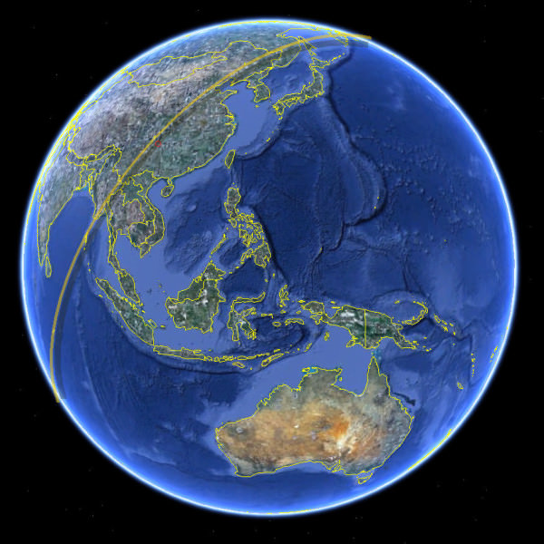
Initial reports said ROSAT fell sometime during this track. Credit: DLR and ROSAT_Reentry Twitter.

[/caption]

It’s official: the ROSAT satellite has come down. The Deutsches Zentrum für Luft- und Raumfahrt (DLR), the German Space Agency confirmed the satellite plunged to Earth sometime between 1:45 UTC and 2:15 UTC on Oct. 23, 2011 (between 8:45 and 9:15 EDT Oct. 22) There is currently no confirmation if pieces of debris have reached Earth’s surface.

Update: US Strategic Command estimates an entry time of 1:50 UTC +/- 7 Minutes. This entry time would put the satellite in the Indian Ocean, and not over China as reported below. The DLR said that after further analysis they should be able to provide more information about exactly where the debris hit.

The @ROSAT_Reentry Twitter feed posted the picture above, indicating the satellite’s fall occurred sometime during the groundtrack shown.

Other reports via Twitter from skywatchers around the world had no sightings of any lit debris falling, or any actual sightings of the satellite passing overhead since 23:30 UTC on Oct. 22. Some news reports say it could have re-entered over China, but it likely didn’t make it as far as Korea or Japan.

We’ll provide more information when it becomes available.

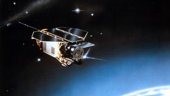
ROSAT Satellite. Credit: DLR

Latest Update on ROSAT Satellite: Uncontrolled Re-Entry on Oct. 22 or 23

This latest video rendering from from Analytical Graphics, Inc. (AGI) shows ROSAT’s current orbit, the satellite’s ground track, and the estimated model of the break-up and debris scattering. Deutsches Zentrum für Luft- und Raumfahrt (DLR), the German Space Agency has now refined the re-entry to sometime between October 22 and 23, 2011, plus or minus one day. DLR says this slot of uncertainty will be reduced as the date of re-entry approaches. However, even one day before re-entry, the estimate will only be accurate to within plus/minus five hours.

The orbit extends from 53 degrees northern and southern latitude, and all areas in that region could be affected by its re-entry. The bulk of the debris will impact near the ground track of the satellite, but larger parts of the satellite, including its 32 inch, 400 kg mirror, could fall to Earth in a 80-kilometer-wide path along the track.

Update: A report from the ROSAT_Renetry Twitter feed posted at 18:00 UT on October 20 said they expect re-entry in 64 hours. “ROSAT orbit 88.58 minutes 196.8 x 201.7 km, Position 26.6S,164.0W alt=203.2km Lit ~Re-entry 64 hours”

We’ll provide more updates as they become available. You can check the DLR ROSAT webpage for more updates.

All-Sky Camera Captures Mysterious Flashes

Every couple of weeks or so a strange flash appears on an all-sky camera that searches for meteors. What could it be? Take a look at the video above and maybe you can help solve the mystery.

“They are not iridium flares because they are stationary,” said James Beauchamp, an amateur astronomer who hosts the meteor camera for Sandia National Labs and New Mexico State University, and who posted this video on You Tube. “And they are not geosynchronous satellites because the azimuth/elevation are too far North. They are reflective because they always happen just prior to or after sunrise/sunset. Whatever it is, it’s slow and BIG.”
Continue reading “All-Sky Camera Captures Mysterious Flashes”