Music From Space: DIY Satellite Will Capture Sounds of Ionosphere

Artist concept of an InterOrbital Tubesat in space. Credit: InterOrbital.

[/caption]

For a space geek, the ultimate do-it-yourself project would be building a satellite in your basement. Astronomer and writer Sandy Antunes is doing just that, but there’s an artsy side to this project, as well. His satellite, called Project Calliope, will collect data from the ionosphere and send it back to Earth in sound-based MIDI files, allowing music to be created from space. “It’ll be an ionospheric detector transmitting sonifiable data back to Earth,” said Antunes. “Conceptually, it’s a musical instrument in space, played by space rather than just after-the-fact sonified.”

Antunes decided to embark on this project after the commercial space company InterOrbital began offering small DIY, soda-can-sized picosatellites for the reasonable price of $8,000 – which includes the launch.

One of the major reasons for doing the project is to prove that anyone can build a satellite in their basement – although Antunes admits it is also a fairly cheap midlife crisis expenditure, especially when his boss at the Science 2.0 blog, Hank Campbell, decided to pitch in half of the price.

The skeleton of the Antunes' satellite, assembled. Cat is for scale. Credit: Sandy Antunes.

“When people ask, ‘where did you get your idea?’ that misses the mark,” Antunes told Universe Today. “The question should be, ‘What idea do you have?’ We’re at the point now where a single hobbyist can send something into orbit to do something useful. I think this is a new space age way of thinking. I’d like to see if this inspires people to do something cooler than me. To me that is what science is all about.”

Antunes is documenting his experiences on his blog, The Sky By Day. “I’m making mistakes so that other people won’t have to make them,” he said. “Hopefully I can make the path will be easier for others.”

Plus, Antunes hopes to answer the big question of what space sounds like. The sun interacts with the Earth’s magnetic field in the ionosphere, creating all sorts of activity; there are also changes in temperature and light.

“People don’t know what space sounds like,” he said. “You walk to ocean and close your eyes and you can hear the roar of the waves, the rushing of water, the moments of quiet; and you can get a good idea of what activity is going on. But we don’t know have an idea of the activity of space, or the ionosphere, where this satellite is going. Sonifying the ionosphere will give people an idea of the ebb and flow of it – how there are constant events going on, sometimes catastrophic-type events but there is also a quiescent stage.”

When the data comes back to Earth, Antunes will give musicians free rein. “Musicians can take it and rework it, much like how musicians have ambient noise, nature sounds, or whale songs in a piece,” Antunes said, “but in this case they can take sounds from the ionosphere. We are making it royalty free so anyone can use it.”
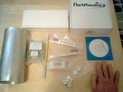
The packaged components for InterOrbital's $8,000 DIY satellite. Credit: Sandy Antunes.

Antunes said working with the pre-packaged TubeSat Personal Satellite Kit is different than what he initially imagined. The Hubble Space Telescope, it is not.

“It has a power system that’s basically two lithium AA batteries hooked together, a little stick of gum computer chip, and some very fragile solar cells,” Antunes said. “I thought it would be hard science and tricky engineering and unsolved problems, but everything I’m getting is off the shelf. The sensors are plug-ins, so the primary work is integrating things. So there are very different problems from what I thought, but this tells me that you don’t have to have a PhD to put up a satellite.”

The current liftoff date for the first InterOrbital Tubesat launch is March or April of 2011. The company has built the rocket engines and they are now doing testing and test firings.

Antunes knows that testing a rocket has a lot of ambiguity, and he anticipates some delays, as even when he has been part of a NASA project, he has never had a launch go on time. This being the first launch of InterOrbital’s commercial satellite venture, if it blows up, Antunes will get a chance to refly his satellite.

Project Calliope will go into a short-term polar orbit, and last about 6-12 weeks, so it is a short term experience, Antunes said.

But he will be tweaking his satellite right up until delivery.

“I wanted to do something that NASA cannot, and that a University wouldn’t, combining art and science,” Antunes said. “I like the idea of flying something in space whose purpose is to make music until it dies– music from science.”

Listen to Antunes on the 365 Days of Astronomy explain why his small satellite will not hit you on the head.

Mount Merapi Still Blowing off Steam

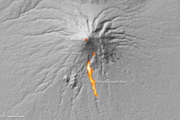
Merapi Volcano on November 10, 2010, when the Moderate Resolution Imaging Spectroradiometer (MODIS) on NASA’s Terra satellite. Credit: NASA

[/caption]

For about three weeks, Indonesia’s Mount Merapi has been belching out lava, as well as ash and gas, clouding the atmosphere above. This satellite image, taken by NASA’s MODIS instrument on the Terra satellite, shows the volcano now settling down and is the most cloud-free satellite view of the volcano that we’ve been able to see. Thick ash is still rising and the volcano is still considered to be erupting at dangerous levels. Merapi is one of Indonesia’s most active volcanoes, and this eruption has been the most violent since the 1870’s.

The dark brown streak down the southern face of the volcano is ash and other volcanic material deposited by a pyroclastic flow or lahar. The volcano has been blamed for 156 deaths and about 200,000 people had to evacuate. The ash also caused flights to be delayed or canceled.

See below for a thermal image of the lava flow.

The Advanced Spaceborne Thermal Emission and Reflection Radiometer (ASTER) on NASA’s Terra satellite captured the thermal signature of hot ash and rock and a glowing lava dome on Mount Merapi on Nov. 1, 2010. Credit: NASA.

As a very active volcano, Merapi poses a constant threat to thousands of people in Indonesia. The Advanced Spaceborne Thermal Emission and Reflection Radiometer (ASTER) on NASA’s Terra satellite captured the thermal signature of hot ash and rock and a glowing lava dome. The thermal data is overlaid on a three-dimensional map of the volcano to show the approximate location of the flow. The three-dimensional data is from a global topographic model created using ASTER stereo observations.

For more information see NASA’s Earth Observatory website.

‘Secret’ X-37B Space Plane Disappears Again

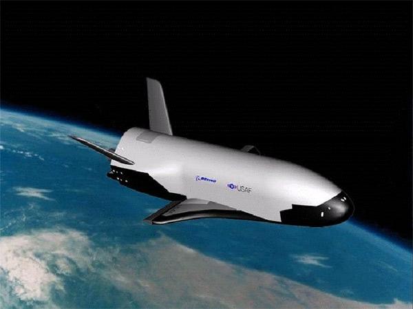
Artist impression of the Boeing X-37B (USAF)

[/caption]

The game between the United States Air Force and amateur satellite trackers continues: the unmanned X-37B space plane – a classified project of the Air Force – has changed orbit once again, leaving those that monitor the flyovers of the space plane scrambling to locate it once again.

The X-37B was launched on April 22nd, 2010 on an Atlas V rocket from Cape Canaveral, Florida, and has been orbiting the Earth ever since. During the period between July 29th and August 14th of this year, the plane changed its orbit and forced the amateurs that monitor the satellite to find it again, and recalculate its orbital path. According to Spaceweather.com yesterday, the X-37B has once again changed its location. It did not pass over at the expected time on the nights of October 7th and October 9th.

Possibilities for this latest change in orbit include a simple maneuvering test or change in the current testing phase of the plane, or the potential that it is finally about to land. The gallium arsenide solar panels on the craft should allow it to stay in space for up to 270 days, but it has only been 173 days since the launch.

The X-37B is controlled remotely, and can automatically land. Once this flight is over, it will land at either the Vandenberg Air Force Base or the Edwards Air Force Base, both located in California.

Not much has been said about the the secret project by the Air Force. Started at NASA in 1999, the automated space plane was handed over to the Pentagon in 2004. This initial flight of the X-37B is billed as a test of the craft by the Air Force. Here’s its description according to the Air Force fact sheet:

“The X-37B Orbital Test Vehicle, or OTV, is a non-operational system that will demonstrate a reliable, reusable, unmanned space test platform for the U.S. Air Force. The objectives of the OTV program include space experimentation, risk reduction and a concept of operations development for reusable space vehicle technologies.”

Of course, there has been much speculation about whether this constitutes the “weaponization of space”, since it is, after all, a project of the Air Force instead of NASA. To put your mind at ease, here’s a link to an analysis of potential uses of the X-37B by former Air Force officer Brian Wheeden, who is now a Technical Adviser to the Secure World Foundation. He places the likelihood that the space plane could be used as a weapon at zero, but its capabilities as an orbital spy platform are feasible.

If you want a comprehensive look into the history and the possible uses of the X-37B, there is a lengthy article over at Air & Space by associate editor Michael Klesius.

There’s also a video up on Space.com by satellite tracker Kevin Fetter of Brockville, Ontario showing a flyover of the plane.

We’ll keep you posted as to when the X-37B is recovered by amateurs, if it has landed, or in the unlikely event that the Air Force decides to release any information about its current mission.

Source: Spaceweather.com

So, You Want to Build a Satellite?

A light-hearted look from the upcoming MAVEN (Mars Atmosphere and Volatile Evolution) mission to Mars of what it takes to create a satellite mission for NASA — even before you ever start building it. And the MAVEN folks should know — NASA has just given the mission a green light to continue the development of the mission, which will investigate the mystery of how Mars lost much of its atmosphere. The approval to proceed followed a review at NASA Headquarters of the detailed plans, instrument suite, budget, and risk factor analysis for the spacecraft. You can see how that all works, (presumably problem free) in this witty little video.
Continue reading “So, You Want to Build a Satellite?”

No Glory: NASA Delays Climate Change Satellite Mission

Artists impression of the Glory satellite at work. Credit: NASA

[/caption]

A satellite mission to study climate change on Earth has been delayed due to problems with its solar arrays. The Glory mission was scheduled for a November 22, 2010 launch, but it now has been tentatively pushed back to February 23, 2011. Reportedly, ground testing revealed a problem with a mechanism in one of the two solar panels on the Glory satellite. “The new launch date provides the necessary additional time required to complete preparations for the rocket and the spacecraft,” said a NASA status report issued on Friday. The mission is slated to launch on an Orbital Sciences Taurus XL rocket from Vandenberg Air Force Base in California.

The $424 million Glory mission will gather data to help scientists to better understand the Earth’s energy budget. It will look at the properties of aerosols, including black carbon, in the Earth’s atmosphere and climate system, and enable a greater understanding of the seasonal variability of aerosol properties.

It will also collect data on solar irradiance for the long-term effects on the Earth climate record, helping to help in our understanding whether the temperature increase and climate changes are by-products of natural events or whether the changes are caused by man-made sources is of primary importance.

On the last Taurus XL launch in February 2009 — for the Orbiting Carbon Observatory, another NASA climate change research satellite — a fairing failed to separate, and the mission failed.

Source: KSC

New Satellite Launches to Track Space Junk

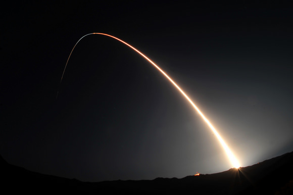
A Minotaur IV rocket launched the Space-Based Space Surveillance satellite. Image: U.S. Air Force/Senior Airman Andrew Lee

[/caption]

The U.S. Air Force successfully launched the Space Based Space Surveillance spacecraft, a first-of-its-kind satellite that can detect and track orbiting space objects from space. The new satellite was blasted into orbit by a Minotaur IV rocket at 9:41 p.m. PDT, September 25th, from Vandenberg Air Force Base in California.

“SBSS will greatly enhance our existing space situational awareness capability, a capability vital to protecting our space-based assets,” said Colonel Richard Boltz from Vandenberg.

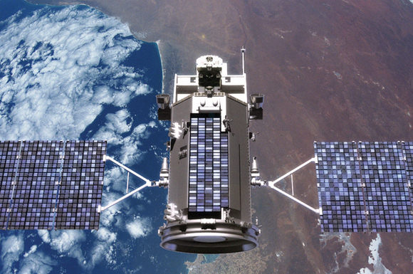
SBSS spacecraft. Image courtesy of Boeing.

There are about 500,000 known pieces of space junk – such as spent rocket boosters, failed satellites, and pieces of satellites – in Earth orbit. Of those, about 21,000 objects are larger than 10.1 cm (4 inches) in diameter. These are being tracked by the Department of Defense, as part of the Space Surveillance Network.

“This satellite is going to revolutionize the way we track objects in space by not being constrained by weather, the atmosphere or the time of day,” said Col. J.R. Jordan, vice-commander of the Space Superiority Systems Wing at the U.S. Air Force Space and Missile Systems Center, in a prelaunch briefing. “This capability will be essential to our space situational awareness architecture for the near future and beyond.”

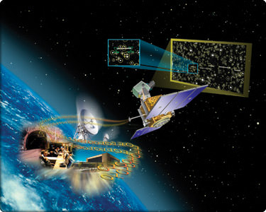
The satellite will be fully operational and handed over to the Air Force Space Command in about 210 days. The SBSS will be able to detect, identify and tracking man-made space objects from deep space to low-earth orbit. The SBSS space vehicle uses a two-axis gimbal in order to observe in all directions. The spacecraft’s on-board mission data processor performs image processing to extract moving targets and reference star pixels to reduce the downlink data size.

This was the third launch in eight days from Vandenberg.

Source: Vandenberg AFB

Satellite Images Show Hurricane Igor Likely to Make Direct Hit on Bermuda

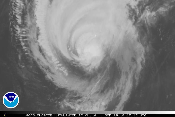
Hurrican Igor as seen by one of the GOES satellites, taken on Sept. 19, 2010 at 17:15 UTC. Credit: NOAA

[/caption]

The massive Hurricane Igor is now a Category One storm, with maximum sustained wind speeds of 140 km per hour, (85 miles per hour). As of this writing at 2:30 EDT, it looks as if it is on a direct collision course with Bermuda and is about 220 km (135 miles) southwest of Bermuda. The intensity of the storm has decreased over the past few days, but the size and rotation of the Igor means that Bermuda will be hit repeatedly as the arms of the hurricane spin over the 54 square kilometer (21 sq mi) island nation. In the satellite image above, Bermuda is the small white dot near the center of the image.

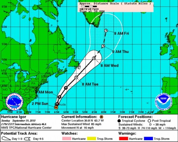
Projected track of Hurricane Igor. Credit: NOAA

Damaging sustained winds of hurricane force will reach the Bermuda late Sunday afternoon, and they will continue into early Monday morning. Wind gusts are predicted to be near or just over 160 km/hour (100 mph) as Igor makes its closest approach to Bermuda. Here’s a link to even more hurricane images.

The hurricane threatens to leave widespread tree damage and power outages in its wake. Some structures will also sustain damage; but fortunately, many buildings on Bermuda are made of stone with foundations into bedrock.

Flooding is also a serious concern across Bermuda. Igor will not only drop 4 to 8 inches of rain but will also trigger a 6- to 10-foot storm surge. Worsening the situation is the fact that waves pounding Bermuda will rise to heights in excess of 40 feet into this evening.

The massive size of Igor will cause the hurricane to keep battering the island well into Monday afternoon.

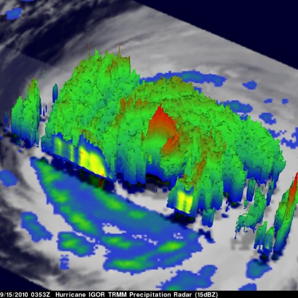
This 3-D image of Igor's cloud heights and rainfall from NASA TRMM satellite. Credit: Credit: NASA/SSAI, Hal Pierce

This 3-D image of Igor’s cloud heights and rainfall from NASA TRMM data shows a large area of heavy rainfall (falling at about 2 inches per hour) shown here in red on Sept. 15 at 0353 UTC. The yellow and green areas indicate moderate rainfall between .78 to 1.57 inches per hour. The image reveals that Igor’s eye was still very distinct but the southwestern portion of the eye wall had eroded.

Sources: NOAA, AccuWeather, JPL

Students Send ICESat to a Fiery Deorbit Death

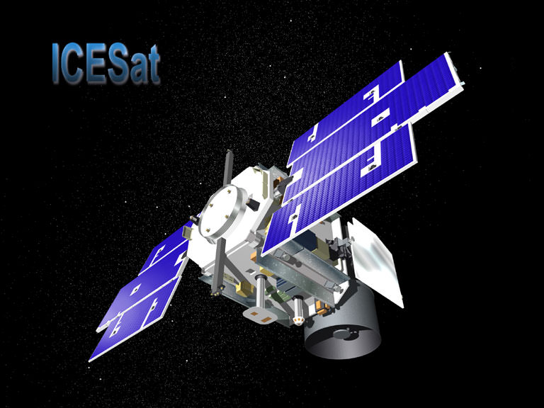
ICESat. Image courtesy Ball Aerospace.

[/caption]

NASA’s Ice, Cloud, and land Elevation (ICESat) mission is now on ice, so to speak, or perhaps we should say, it ultimately became an inferno. The satellite was intentionally deorbited and burned up in the atmosphere on August 30, after completing a very productive seven-year scientific stint in orbit. And talk about the ultimate high-stakes, high-adventure, hands-on student project: students at the University of Colorado Boulder conducted the final maneuvers to send the spacecraft to its fiery death.

ICESat’s science mission ended in February 2010 when its primary instrument failed. NASA lowered the satellite’s orbit this summer and then decommissioned the spacecraft in preparation for re-entry. The satellite largely burned up, (NASA calculated that no more than 90 kg (200 pounds) of the ICESat’s original 900 kg (2,000 pounds) would survive re-entry) with pieces of debris falling into the Barents Sea, part of the Arctic Ocean north of Norway and Russia.

Originally a slated for 3 year mission, it continued for seven years and 15 laser-operations campaigns. While the GLAS instrument failed, the spacecraft itself remained in operating condition, so NASA could fire its thrusters to lower its orbit. This began in June, and reduced the lowest point of the spacecraft’s orbit to 125 miles (200 km) above Earth’s surface. The orbit then naturally decayed, but the final maneuvering was controlled by a group of students from the University of Colorado, working at the school’s Laboratory for Atmospheric and Space Physics (LASP). They sent it successfully plummeting through Earth’s atmosphere at just the right moment so that the satellite’s remains would land in the chilly – and uninhabited — seas north of Norway and Russia.

“They ran calculations to determine where the spacecraft was located,” said Darrin Osborne, flight director for ICESat.

The student operators provide a lower cost to NASA, and CU students at LASP receive hands-on training and experience that helps position them for a future in space-related careers.

“It’s amazing for an undergraduate like me to get hands-on experience controlling multimillion-dollar NASA satellites,” said third-year aerospace engineering sciences student Katelynn Finn, quoted in an article in The Register.

ICESat orbital image. Credit: NASA

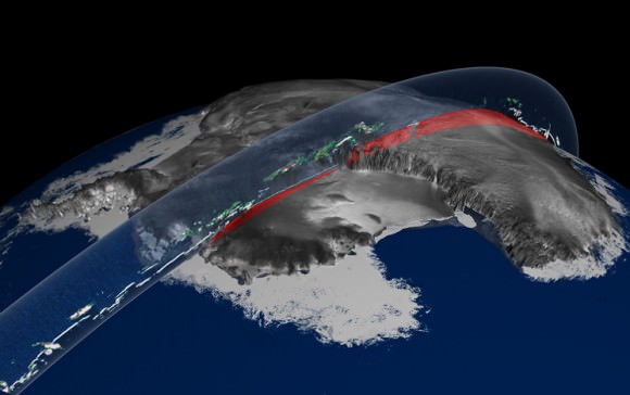
ICESat was launched in January, 2003, and was the first mission of its kind, designed to study Earth’s polar regions with a space-based laser altimeter called the Geoscience Laser Altimeter System, or GLAS. ICESat has helped in our understanding of ice sheet and sea ice dynamic, leading to scientific advances in measuring changes in the mass of the Greenland and Antarctic ice sheets, polar sea ice thickness, vegetation-canopy heights, and the heights of clouds and aerosols. Using ICESat data, scientists identified a network of lakes beneath the Antarctic ice sheet. ICESat introduced new capabilities, technology and methods such as the measurement of sea ice freeboard – or the amount of ice and snow that protrudes above the ocean surface – for estimating sea ice thickness.

A final eulogy for the satellite was offered by NASA’s Earth Science Mission Operations office: “The ICESat mission operations team is commended for its exceptional performance, working tirelessly for the past eleven years (four years of preparation and seven years of operations), overcoming several obstacles in the early years of the mission, and closing out the mission with a flawless series of orbital maneuvers before final decommissioning. The positive control maintained over the mission right to the end shows the quality and effort that went into designing, building, qualifying, launching, and operating a tremendously successful mission such as ICESat.”

The Register, NASA

Two Chinese Satellites Rendezvous in Orbit

The six SJ-06 series satellites in Earth orbit. Credit: The Space Review

[/caption]

Data from the US military shows that two Chinese satellites likely performed multiple rendezvous 600 kilometers above Earth this summer, and may have even bumped into each other. The rendezvous have taken place over the past several months, between two Chinese “Shi Jian” (Practice) spacecraft, SJ-06F and SJ-12, that are officially listed as science satellites.

News of the Chinese satellite encounters was first reported by a Russian news source in mid-August, and this week Brian Weeden from the Secure World Foundation wrote an extensive article for The Space Review.

Weeden said the maneuvers could be a rehearsal for the technology needed to build a space station, but it also shows China may now have the ability to approach and potentially interfere with other satellites.
“On-orbit rendezvous is a complex operation, and one that has only been done a few of times before, most notably by the US satellite XSS-11,” Weeden wrote, “which inspected the rocket body that placed it in LEO, and one of the US MiTEx satellites, which inspected the failed DSP-23 satellite in GEO. The rendezvous of two Chinese satellites demonstrates that China is broadening its space capabilities, but also touches on the greater issue of perceptions, trust, and safety in space activities that could impact the long-term sustainability of the space regime.”

Weeden said US military data suggests that one satellite may have been bumped and its orbit altered slightly on August 19. The change in its orbit can’t be explained by the usual things that affect satellites, such as the drag from the Earth’s atmosphere.

In January 2007, China destroyed a derelict satellite with a ballistic missile, which the US also did in February 2008.

For now, one can only speculate about the reasons for China performing these types of difficult and rare maneuvers with their satellites. You can read more about the technical nature of the events on The Space Review.

New Satellite for Monitoring Space Debris To Launch

The Air Force Space Based Space Surveillance (SBSS) system. Credit: Boeing

[/caption]

The U.S. Air Force will launch the first-ever satellite dedicated solely to tracking the positions of other satellites and the thousands of pieces of space debris in Earth orbit. The $500 million Space-Based Space Surveillance satellite, scheduled for a July 8 launch from Vandenberg Air Force Base, in California, will continuously monitor the “traffic” around the Earth, providing an unobstructed view day or night. Currently, the ground-based radar and optical telescopes used to track satellites and space junk can only be used on clear nights, and not all the observatories are powerful enough to detect objects in high or geosynchronous orbits.

This is the first satellite in the SBSS System that will eventually lead to a constellation of satellites to detect and track orbiting space objects, according to Boeing, the prime contractor for this first “Pathfinder” satellite. While the Air Force is the primary user of the SBSS satellites, the US Department of Defense will also use data from the eventual satellite system to support military operations, and NASA can use the information to calculate orbital debris collision-avoidance measures for the International Space Station and Space Shuttle missions.

The Air Force estimates there are about 1,000 functioning satellites and about 20,000 pieces of debris orbiting Earth.

The new satellite will be in orbit 627 kilometers (390 miles) above the Earth, and has an optical camera on a swivel mount, so the camera’s view can be changed without burning fuel to move the satellite, and will concentrate on satellites and debris in deep space. The information from the satellite will be sent to a command center at Schriever Air Force Base in Colorado.

The Air Force space surveillance network previously had partial use of a satellite called the Midcourse Space Experiment, which was designed to track missiles but could also monitor objects in orbit. It’s no longer functioning.

Right now, the Air Force can detect objects as small as 10 centimeters across, or about 4 inches, and they have not released information on the the capabilities of the new satellite.

The Secure World Foundation says there could be millions of pieces of debris in total around the Earth. Debris at altitudes above several hundred kilometers can stay in orbit for decades or even centuries, and those about 1,500 kilometers will remain in orbit for thousands of years. Even very small particles of space debris can have a devastating effect on anything they hit because of their high relative impact velocities.

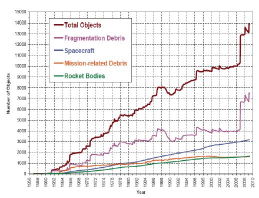
Chart of orbital debris. Source: NASA Orbital Debris Quarterly News, April 2009,

This chart displays a summary of all objects in Earth orbit officially cataloged by the U.S. Space Surveillance Network. “Fragmentation Debris” includes satellite breakup debris and anomalous event debris, while “Mission?related Debris” includes all objects dispensed, separated, or released as part of the planned mission. Note the dramatic increase in fragmentation debris caused by the Chinese ASAT test conducted in January 2007. Another smaller increase is noted following the 2009 collision between an Iridum communications satellite and a non-functioning Russian satellite.

It is hoped the new SBSS satellite will increase the capabilities to help avoid future collisions.

Sources: Boeing, Secure World Foundation, AP