Curiosity is Back! Snapping Fresh Martian Vistas

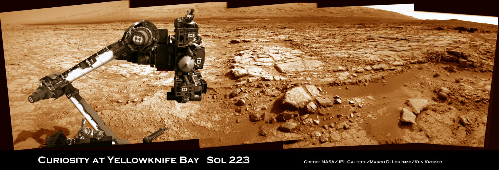
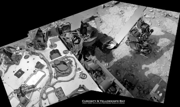
Curiosity's raised robotic arm and drill are staring at you in this new panoramic vista of Yellowknife Bay basin snapped on March 23, Sol 223 by the rover's navigation camera system. The raw images were stitched by Marco Di Lorenzo and Ken Kremer and colorized. Credit: NASA/JPL-Caltech/Marco Di Lorenzo/KenKremer (kenkremer.com)

Curiosity is back! After a multi-week hiatus forced by a computer memory glitch, NASA’s mega rover is back to full operation.

And the proof is crystal clear in the beautiful new panoramic view (above) snapped by Curiosity this weekend from Yellowknife Bay, showing the robot’s arm and drill elevated and aiming straight at you – raring to go and ready to feast on something deliciously Martian.

“That drill is hungry, looking for something tasty to eat, and ‘you’ (loaded with water and organics) are it,” I thought with a chuckle as Curiosity seeks additional habitats and ingredients friendly to life.

So my imaging partner Marco Di Lorenzo and I celebrated the great news by quickly creating the new panoramic mosaic assembled from images taken on Saturday, March 23, or Sol 223, by the robot’s navigation cameras. Our new Curiosity mosaic was first featured on Saturday at NBC News Cosmic Log by Alan Boyle – while I was hunting for Comet Pan-STARRS.

So the fact that Curiosity is again snapping images and transmitting fresh alien vistas and new science data is a relief to eagerly waiting scientists and engineers here on Earth.

Drilling goes to the heart of the mission. It was absolutely essential to the key finding of Curiosity’s Martian foray thus far – that Mars possesses an environment where alien microbes could once have thrived in the distant past when the Red Planet was warmer and wetter.

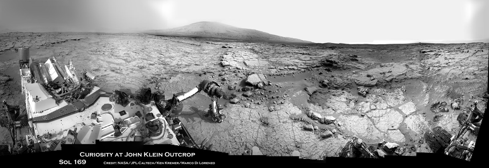
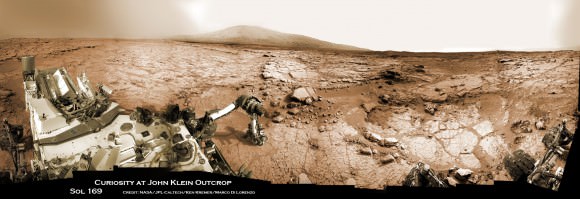
Curiosity accomplished Historic 1st drilling into Martian rock at John Klein outcrop on Feb 8, 2013 (Sol 182), shown in this context mosaic view of the Yellowknife Bay basin taken on Jan. 26 (Sol 169) where the robot is currently working. The robotic arm is pressing down on the surface at John Klein outcrop of veined hydrated minerals – dramatically back dropped with her ultimate destination; Mount Sharp. Credit: NASA/JPL-Caltech/Ken Kremer/Marco Di Lorenzo

Curiosity has found widespread evidence for repeated episodes of flowing liquid water on the floor of her Gale Crater landing site – an essential prerequisite to life as we know it.

After coring and analyzing the first powder ever drilled from the interior of a Martian rock in February 2013, NASA’s Curiosity robot discovered some of the key chemical ingredients necessary to support life on early Mars billions of years ago.

Curiosity found that the fine-grained, sedimentary mudstone rock at the rovers current worksite inside the Yellowknife Bay basin possesses significant amounts of phyllosilicate clay minerals; indicating the flow of nearly neutral liquid water and a habitat friendly to the possible origin of simple Martian life forms eons ago.

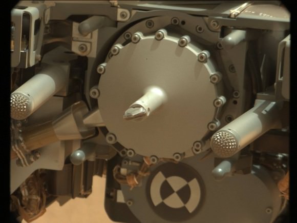
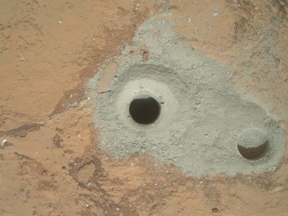
Curiosity's First Sample Drilling hole is shown at the center of this image in a rock called "John Klein" on Feb. 8, 2013, or Sol 182 operations. The image was obtained by Curiosity’s Mars Hand Lens Imager (MAHLI). The sample-collection hole is 0.63 inch (1.6 centimeters) in diameter and 2.5 inches (6.4 centimeters) deep. The “mini drill” test hole near it is the same diameter, with a depth of 0.8 inch (2 centimeters). Credit: NASA/JPL-Caltech/MSSS
Curiosity’s First Sample Drilling hole is shown at the center of this image in a rock called “John Klein” on Feb. 8, 2013, or Sol 182 operations. The image was obtained by Curiosity’s Mars Hand Lens Imager (MAHLI). The sample-collection hole is 0.63 inch (1.6 centimeters) in diameter and 2.5 inches (6.4 centimeters) deep. The “mini drill” test hole near it is the same diameter, with a depth of 0.8 inch (2 centimeters). Credit: NASA/JPL-Caltech/MSSS

The rovers 7 foot (2.1 meter) long robotic arm fed aspirin sized samples of the gray, pulverized powder into the miniaturized CheMin and SAM analytical instruments on Feb. 22 and 23, or Sols 195 and 196. The samples were analyzed on Sol 200 and then the rover experienced her first significant problems since landing on Aug. 5, 2012.

The Chemistry and Mineralogy (CheMin) instrument and Sample Analysis at Mars (SAM) instruments test the Martian soil and rock samples to determine their chemical composition and search for traces of organic molecules – the building blocks of life

No organics have been found thus far.

The rover’s science mission has been on hold for nearly a month since “a memory glitch on the A-side computer on Feb. 27, which prompted controllers to command a swap from the A-side computer to the B-side computer,” according to a NASA statement.

“That operator-commanded swap put Curiosity into safe mode for two days. The rover team restored the availability of the A-side as a backup and prepared the B-side to resume full operations.”

The memory issue may have been caused by a cosmic ray strike. The rover suffered another minor setback last week, briefly reentering ‘safe mode’. And in between, a solar storm forced the team to shut Curiosity down for a few more days.

All appears well now.

The next step is to reanalyze those 1st gray rock tailings to continue the hunt for traces of organic molecules.

But the next solar conjunction will interrupt communications starting around April 4 for several weeks. More on that shortly.

After conjunction, Curiosity will resume her drilling campaign

Ken Kremer

…………….

Learn more about Curiosity’s groundbreaking discoveries and NASA missions at Ken’s upcoming lecture presentations:

April 20/21 : “Curiosity and the Search for Life on Mars – (in 3-D)”. Plus Orion, SpaceX, Antares, the Space Shuttle and more! NEAF Astronomy Forum, Suffern, NY

April 28: “Curiosity and the Search for Life on Mars – (in 3-D)”. Washington Crossing State Park, Titusville, NJ, 130 PM

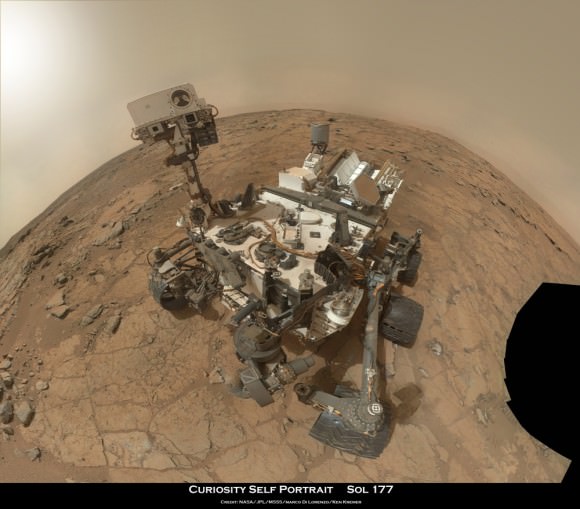
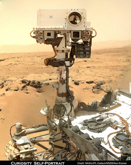
Rover self portrait MAHLI mosaic taken this week has Curiosity sitting on the flat rocks of the “John Klein” drilling target area within the Yellowknife Bay depression. Note gradual rise behind rover. Credit: NASA/JPL-Caltech/MSSS/Marco Di Lorenzo/www.KenKremer.com.
Rover self portrait MAHLI mosaic taken this week has Curiosity sitting on the flat rocks of the “John Klein” drilling target area within the Yellowknife Bay depression. Note gradual rise behind rover. Credit: NASA/JPL-Caltech/MSSS/Marco Di Lorenzo/Ken Kremer (kenkremer.com)

Curiosity Demonstrates New Capability to Scan 360 Degrees for Life Giving Water – and is Widespread

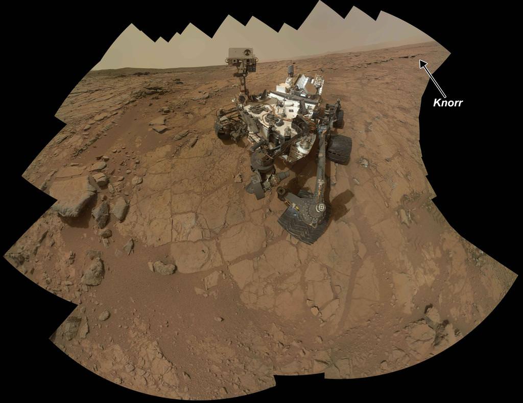
Rock Target ‘Knorr’ Near Curiosity. Scientists used Curiosity's Mast Camera (Mastcam) to study spectral characteristics of the rock target called Knorr in the Yellowknife Bay area and determined that it possessed veins of hydrated minerals, including hydrated calcium sulfate. This self-portrait is a mosaic of images taken by Curiosity's Mars Hand Lens Imager (MAHLI) camera during Sol 177 (Feb. 3, 2013). Credit: NASA/JPL-Caltech/MSSS

The science team guiding NASA’s Curiosity Mars Science Lab (MSL) rover have demonstrated a new capability that significantly enhances the robots capability to scan her surroundings for signs of life giving water – from a distance. And the rover appears to have found that evidence for water at the Gale Crater landing site is also more widespread than prior indications.

The powerful Mastcam cameras peering from the rovers head can now also be used as a mineral-detecting and hydration-detecting tool to search 360 degrees around every spot she explores for the ingredients required for habitability and precursors to life.

Researchers announced the new findings today (March 18) at a news briefing at the Lunar and Planetary Science Conference in The Woodlands, Texas.

“Some iron-bearing rocks and minerals can be detected and mapped using the Mastcam’s near-infrared filters,” says Prof. Jim Bell, Mastcam co-investigator of Arizona State University, Tempe.

Bell explained that scientists used the filter wheels on the Mastcam cameras to run an experiment by taking measurements in different wavelength’s on a rock target called ‘Knorr’ in the Yellowknife Bay area were Curiosity is now exploring. The rover recently drilled into the John Klein outcrop of mudstone that is crisscrossed with bright veins.

Curiosity accomplished Historic 1st drilling into Martian rock at John Klein outcrop on Feb 8, 2013 (Sol 182), shown in this context mosaic view of the Yellowknife Bay basin taken on Jan. 26 (Sol 169) where the robot is currently working. The robotic arm is pressing down on the surface at John Klein outcrop of veined hydrated minerals – dramatically back dropped with her ultimate destination; Mount Sharp. Credit: NASA/JPL-Caltech/Ken Kremer/Marco Di Lorenzo
Curiosity accomplished Historic 1st drilling into Martian rock at John Klein outcrop on Feb 8, 2013 (Sol 182), shown in this context mosaic view of the Yellowknife Bay basin taken on Jan. 26 (Sol 169) where the robot is currently working. The robotic arm is pressing down on the surface at John Klein outcrop of veined hydrated minerals – dramatically back dropped with her ultimate destination; Mount Sharp. Credit: NASA/JPL-Caltech/Ken Kremer (kenkremer.com)/Marco Di Lorenzo

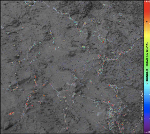
Researchers found that near-infrared wavelengths on Mastcam can be used as a new analytical technique to detect the presence of some but not all types of hydrated minerals.

“Mastcam has some capability to search for hydrated minerals,” said Melissa Rice of the California Institute of Technology, Pasadena.

“The first use of the Mastcam 34 mm camera to find water was at the rock target called “Knorr.”

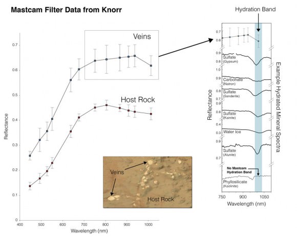
“With Mastcam, we see elevated hydration signals in the narrow veins that cut many of the rocks in this area. These bright veins contain hydrated minerals that are different from the clay minerals in the surrounding rock matrix.”

Mastcam thus serves as an early detective for water without having to drive up to every spot of interest, saving precious time and effort.

Hydration in Veins and Nodules at ‘Knorr’ rock in Yellowknife bay. At different locations on the surface of the same rock, scientists can use the Mast Camera (Mastcam) on Curiosity to measure the amount of reflected light at a series of different wavelengths to obtain spectral information about composition.  The inset photograph shows two locations on a rock target called "Knorr," where Mastcam spectral measurements were made: A light-toned vein and part of the host rock. The main graph shows the spectra recorded at those two points, with increasing wavelengths of visible light and near-infrared light from left to right, and with increasing intensity of reflectance from bottom to top. The bright vein shows greater reflectance through the range of wavelengths assessed. The shapes of the two curves also differ, especially where the vein spectrum dips in the near-infrared wavelengths. The range of wavelengths included in box-outlined portion of the vein spectrum is shown at the top of the group of reference spectra to the right. These reference spectra show how the dip in reflectance at those wavelengths in the vein material corresponds to dips in those wavelengths in several types of hydrated minerals -- minerals that have molecules of water bound into their crystalline structure, including hydrated calcium-sulfates. Mastcam is not sensitive to all hydrated minerals, however, including many phyllosilicates. Credit: NASA/JPL-Caltech/MSSS/ASU
Hydration in Veins and Nodules at ‘Knorr’ rock in Yellowknife bay. At different locations on the surface of the same rock, scientists can use the Mast Camera (Mastcam) on Curiosity to measure the amount of reflected light at a series of different wavelengths to obtain spectral information about composition. The inset photograph shows two locations on a rock target called “Knorr,” where Mastcam spectral measurements were made: A light-toned vein and part of the host rock. The main graph shows the spectra recorded at those two points, with increasing wavelengths of visible light and near-infrared light from left to right, and with increasing intensity of reflectance from bottom to top. The bright vein shows greater reflectance through the range of wavelengths assessed. The shapes of the two curves also differ, especially where the vein spectrum dips in the near-infrared wavelengths. The range of wavelengths included in box-outlined portion of the vein spectrum is shown at the top of the group of reference spectra to the right. These reference spectra show how the dip in reflectance at those wavelengths in the vein material corresponds to dips in those wavelengths in several types of hydrated minerals — minerals that have molecules of water bound into their crystalline structure, including hydrated calcium-sulfates. Mastcam is not sensitive to all hydrated minerals, however, including many phyllosilicates. Credit: NASA/JPL-Caltech/MSSS/ASU

But Mastcam has some limits. “It is not sensitive to the hydrated phyllosilicates found in the drilling sample at John Klein” Rice explained.

“Mastcam can use the hydration mapping technique to look for targets related to water that correspond to hydrated minerals,” Rice added. “It’s a bonus in searching for water!”

The key finding of Curiosity thus far is that the fine-grained, sedimentary mudstone rock at the Yellowknife Bay basin possesses a significant amount of phyllosilicate clay minerals; indicating an environment where Martian microbes could once have thrived in the distant past.

“We have found a habitable environment which is so benign and supportive of life that probably if this water was around, and you had been on the planet, you would have been able to drink it,” said John Grotzinger, the chief scientist for the Curiosity Mars Science Laboratory mission at the California Institute of Technology in Pasadena, Calif.

Ken Kremer

Hydration Map, Based on Mastcam Spectra for ‘Knorr’ rock target shows coded map of the amount of mineral hydration indicated by a ratio of near-infrared reflectance intensities measured by Curiosity. The color scale on the right shows the assignment of colors for relative strength of the calculated signal for hydration. The map shows that the stronger signals for hydration are associated with pale veins and light-toned nodules in the rock. The Mastcam observations were conducted during Sol 133 (Dec. 20, 2012). The width of the area shown in the image is about 10 inches (25 centimeters). Credit: NASA/JPL-Caltech/MSSS/ASU

Curiosity Discovers Environment Where Life Could have Thrived on Ancient Mars

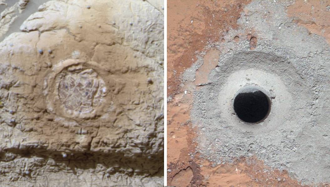
This set of images shows the results from the rock abrasion tool from Opportunity (left) and the drill from NASA's Curiosity rover (right). Note how the rock grindings from Opportunity are brownish red, indicating the presence of hematite, a strongly oxidized iron-bearing mineral. Such minerals are less supportive of habitability and also may degrade organic compounds. On the right is the hole produced by Curiosity during the first drilling into a rock on Mars to collect a sample from inside the rock. In this case, the rock produced gray tailings -- not red -- suggesting the presence of iron that is less oxidized. Curiosity also found clay minerals that form in more neutral water friendly to the formation of life. Credit: NASA

After analyzing the first powder ever drilled from the interior of a Martian rock, NASA’s Curiosity rover discovered some of the key chemical ingredients necessary for life to have thrived on early Mars billions of years ago.

Curiosity has achieved her goal of discovering a habitable environment on the Red Planet, mission scientists reported today at a briefing held at NASA headquarters in Washington, D.C.

Data collected by Curiosity’s two analytical chemistry labs (SAM and CheMin) confirm that the gray powder collected from inside the sedimentary rock where the rover is exploring – near an ancient Martian stream bed – possesses a significant amount of phyllosilicate clay minerals; indicating an environment where Martian microbes could once have thrived in the distant past.

“We have found a habitable environment which is so benign and supportive of life that probably if this water was around, and you had been on the planet, you would have been able to drink it,” said John Grotzinger, the chief scientist for the Curiosity Mars Science Laboratory mission at the California Institute of Technology in Pasadena, Calif.

Curiosity cored the rocky sample from a fine-grained, sedimentary outcrop named “John Klein” inside a shallow basin named Yellowknife Bay, and delivered pulverized powered to the Sample Analysis at Mars (SAM) and Chemistry and Mineralogy (CheMin) instruments inside the robot.

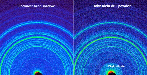
The presence of abundant phyllosilicate clay minerals in the John Klein drill powder indicates a fresh water environment. Further evidence derives from the veiny sedimentary bedrock shot through with calcium sulfate mineral veins that form in a neutral to mildly alkaline pH environment.

This side-by-side comparison shows the X-ray diffraction patterns of two different samples collected from the Martian surface by NASA's Curiosity rover. These images were obtained by Curiosity's Chemistry and Mineralogy instrument (CheMin) and show the patterns obtained from a drift of windblown dust and sand called "Rocknest" and from a powdered rock sample drilled from the "John Klein" bedrock wherer Curiosty corted the frist interior rock samples.  The presence of abundant clay minerals in the John Klein drill powder and the lack of abundant salt suggest a fresh water environment. The presence of calcium sulfates suggests a neutral to mildly alkaline pH environment. NASA/JPL-Caltech/Ames
This side-by-side comparison shows the X-ray diffraction patterns of two different samples collected from the Martian surface by NASA’s Curiosity rover. These images were obtained by Curiosity’s Chemistry and Mineralogy instrument (CheMin) and show the patterns obtained from a drift of windblown dust and sand called “Rocknest” (left) and from a powdered rock sample drilled by Curiosity from the “John Klein” bedrock (right). The presence of abundant phyllosilicate clay minerals in the John Klein drill powder suggest a fresh water environment. The presence of calcium sulfates suggests a neutral to mildly alkaline pH environment. NASA/JPL-Caltech/Ames

“Clay minerals make up at least 20 percent of the composition of this sample,” said David Blake, principal investigator for the CheMin instrument at NASA’s Ames Research Center in Moffett Field, Calif.

The rovers 7 foot (2.1 meter) long robotic arm fed aspirin sized samples of the gray, pulverized powder into the miniaturized CheMin SAM analytical instruments on Feb. 22 and 23, or Sols 195 and 196. The samples were analyzed on Sol 200.

Scientists were able to identify carbon, hydrogen, oxygen, nitrogen, sulfur and phosphorus in the sample – all of which are essential constituents for life as we know it based on organic molecules.

“The range of chemical ingredients we have identified in the sample is impressive, and it suggests pairings such as sulfates and sulfides that indicate a possible chemical energy source for micro-organisms,” said Paul Mahaffy, principal investigator of the SAM suite of instruments at NASA’s Goddard Space Flight Center in Greenbelt, Md.

Curiosity accomplished Historic 1st drilling into Martian rock at John Klein outcrop on Feb 8, 2013 (Sol 182), shown in this context mosaic view of the Yellowknife Bay basin taken on Jan. 26 (Sol 169) where the robot is currently working. The robotic arm is pressing down on the surface at John Klein outcrop of veined hydrated minerals – dramatically back dropped with her ultimate destination; Mount Sharp. Credit: NASA/JPL-Caltech/Ken Kremer/Marco Di Lorenzo

The discovery of phyllosilicates on the floor of Gale crater was unexpected and has delighted the scientists. Based on spectral observations from Mars orbit. Grotzinger told me previously that phyllosilicates had only been detected in the lower reaches of Mount Sharp, the 3 mile (5 km) high mountain that is Curiosity’s ultimate destination.

Grotzinger said today that Curiosity will remain in the Yellowknife Bay area for several additional weeks or months to fully characterize the area. The rover will also conduct at least one more drilling campaign to try and replicate the results, check for organic molecules and search for new discoveries.

Ken Kremer

Curiosity Hammers into Mars Rock in Historic Feat

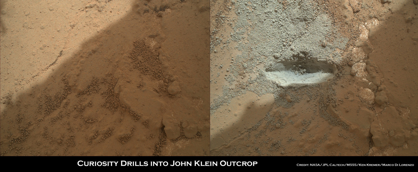
Image caption: Before and after comparison of Curiosity’s 1st ever drill test into Martian rock. Drill bit penetrated several mm and vibrations apparently unveiled hidden, whitish mineral by dislodging thin dust layer at John Klein outcrop in Sol 176 images. Credit: NASA/JPL-Caltech/MSSS/Ken Kremer/Marco Di Lorenzo

A robot from Earth has successfully drilled into a Martian rock for the first time ever and exposed pristine alien material for high powered science analysis.

NASA’s car sized Curiosity rover deliberately plunged the drill bit on the end of her 7 foot (2.1 m) robot arm into a flat outcrop of rocks possessing hydrated mineral veins, that is situated inside a shallow basin named Yellowknife Bay where water repeatedly flowed.

“The drill test was done. The mission has been spectacular so far,” said Dr. Jim Green, Director of NASA Planetary Sciences Division at NASA HQ, in an exclusive interview today with Universe Today on the campus of Princeton University. “The area is tremendously exciting.”

And what’s even more amazing is that as Curiosity hammered straight down into the rock outcrop, it appears that the resulting vibrations also simultaneously uncovered a hidden vein of whitish colored material that might be calcium sulfate – as the Martian ground shook and a thin layer of rust colored soil was visibly dislodged.

The robot is working at a place called Glenelg – where liquid water once flowed eons ago across the Red Planet’s surface.

“This area is really rich with all the cracks in the rocks and the veins. It’s really fabulous,” Green told me. “The landing was an engineering feat that enabled us to do all this great science that comes next.”

Curiosity Sol 174_haz1_Ken Kremer

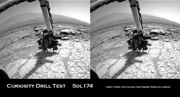
Image caption: Curiosity views 1st plunge of the hammering drill bit up from raised position, at left, to rock outcrop penetration, at right, on Jan 31, 2014, Sol 174 using the front hazard avoidance camera. 3 mile (5 km) high Mount Sharp ultimate destination offers dramatic backdrop. Credit: NASA/JPL-Caltech/Ken Kremer/Marco Di Lorenzo

Drill, Baby, Drill !! — Drilling is essential toward achieving Curiosity’s goal of determining whether Mars ever offered an environment favorable for microbial life, past or present

The drill bit penetrated a few millimeters deep into the intriguing outcrop called ‘John Klein’ as planned during the drill tests run on Jan 31 and Feb 2, 2013 (or Sols 174 & 176), Green elaborated. The results were confirmed in new images snapped by Curiosity over the past few days, that trickled back to Earth this weekend across millions of miles of interplanetary space.

Several different cameras – including the high resolution MAHLI microscopic imager on the arm tool turret – took before and after up-close images to assess the success of the drilling maneuver.

Curiosity Sol 174_1a_Ken Kremer

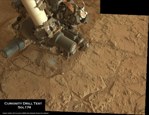
Image caption: Curiosity tool turret located at end of robotic arm is positioned with drill bit in contact with John Klein outcrop for 1st hammer drilling into Martian rock surface on Jan 31, 2013. It’s nearby a spot that was brushed earlier. Credit: NASA/JPL-Caltech/MSSS/Ken Kremer/Marco Di Lorenzo

The Alpha Particle X-Ray Spectrometer (APXS) was also placed in contact with the ground to determine the chemical composition of the rock drill test site and possible calcium sulfate vein and investigate its hydration state.

The drill test marks an historic first time achievement in the annuls of space exploration.

NASA’s Spirit and Opportunity Mars rovers successfully abraded numerous rocks but are not equipped with penetrating drills or sample acquisition and analysis instruments.

During this initial test, Curiosity’s hi-tech drill was used only in the percussion mode – hammering back and forth like a chisel. No tailings were collected for analysis. The 5/8-inch (16 mm) wide bit will be rotated in upcoming exercises to bore several test holes.

Green told me that the Curiosity science and engineering team says that this initial test will soon be following up by more complex tests that will lead directly to drilling into the interior of a rock for the first ever sampling and analysis of fresh, rocky Martian material.

“The drill test results are looking good so far,” Green said. “Depending on the analysis, it’s possible that the initial test bore hole could be drilled as early as tonight. Sampling could follow soon.”

The science and engineering team are wisely being “ultra careful” says Green, in slowly and methodically checking out the highly complex drill.

“We are motivated to work in a stepwise fashion to get it right,” Green elaborated.

“The drilling has got to be done carefully. We are still in checkout mode and the drill is the last instrument of Curiosity’s ten science instruments to be fully checked out.”

0174MR0639000000E1_DXXX

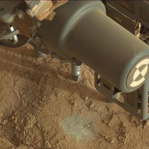
Image caption: Close-up view of Curiosity drill bit penetrating John Klein outcrop during 1st ever drill test into Martian rock on Jan 31, 2013 (Sol 174). Credit: NASA/JPL-Caltech/MSSS

Curiosity can drill to a depth of about 2 inches (5 cm) into rocks. Ultimately a powdered and sieved sample about half an aspirin tablet in size will be delivered to the SAM and CheMin analytical labs on the rover deck.

“The drilling is going very well so far and we’re making great progress with the early steps,” said Curiosity project scientist Prof John Grotzinger to the BBC.

Drilling goes to the heart of the mission. The cored rock samples will be analyzed by the duo of chemical spectrometers to ascertain their elemental composition and determine if organic molecules – the building blocks of life – are present.

The 1 ton robot will spend at least several weeks or more investigating Yellowknife Bay and Glenelg – which lies at the junction of three different types of geologic terrain.

Thereafter, the six-wheeled mega rover will set off on a nearly year long trek to her main destination – the sedimentary layers of the lower reaches of the 3 mile (5 km) high mountain named Mount Sharp.

As the Martian crow flies, the breathtaking environs of Mount Sharp are some 6 miles (10 km) away.

Ken Kremer

Feb 4: Dr Jim Green, Director of NASA’s Planetary Science Division, is presenting a free public lecture at Princeton University at 8 PM titled: “The Revolution in Planetary Science.” Hosted by the Amateur Astronomers Assoc of Princeton. Location: Peyton Hall, Astrophysics Dept. on Ivy Lane, Princeton, NJ.

Curiosity Sol 169_5C1b_Ken Kremer

Image caption: Curiosity conducted Historic 1st drilling into Martian rock at John Klein outcrop shown in this context view of the Yellowknife Bay basin where the robot is currently working. The robotic arm is pressing down on the surface at John Klein outcrop of veined hydrated minerals – dramatically back dropped by her ultimate destination; Mount Sharp. Credit: NASA/JPL-Caltech/Ken Kremer/Marco Di Lorenzo

NLA_412941223EDR_F0060000NCAM00190M

0173MR0897000000E1_DXXX
Image caption: Close-up view of Curiosity drill bit. Credit: NASA/JPL-Caltech/MSSS

Historic First Use of Drill on Mars Set for Jan. 31 – Curiosity’s Sol 174

Image caption: Curiosity will conduct Historic 1st drilling into Martian rock at this spot where the robotic arm is pressing down onto the Red Planet’s surface at the John Klein outcrop of veined hydrated minerals. The Alpha Particle X-Ray Spectrometer (APXS) is in contact with the ground. This panoramic photo mosaic of Navcam camera images was snapped on Jan. 25 & 26, 2013 or Sols 168 & 169 and shows a self-portrait of Curiosity dramatically backdropped with her ultimate destination- Mount Sharp. Credit: NASA/JPL-Caltech/Ken Kremer/Marco Di Lorenzo

The long awaited and history making first use of a drill on Mars is set to happen on Thursday, Jan. 31, 2013, or Sol 174, by NASA’s Curiosity Mars Science Lab (MSL) rover, if all goes well, according to science team member Ken Herkenhoff of the USGS.

Curiosity’s first drilling operation entails hammering a test hole into a flat rock at the location where the rover is currently parked at a scientifically interesting outcrop of rocks with veined minerals called ‘John Klein’. See our mosaics above & below illustrating Curiosity’s current location.

“Drill tailings will not be collected during this test, which will use only the percussion (not rotation) drilling mode,” says Herkenhoff.

Curiosity is an incredibly complex robot that the team is still learning to operate. So the plan could change at a moment’s notice.

The actual delivery of drill tailings to Curiosity’s CheMin and SAM analytical labs is still at least several days or more away and must await a review of results from the test drill hole and further drilling tests.

“We are proceeding with caution in the approach to Curiosity’s first drilling,” said Daniel Limonadi, the lead systems engineer for Curiosity’s surface sampling and science system at NASA’s Jet Propulsion Laboratory (JPL). “This is challenging. It will be the first time any robot has drilled into a rock to collect a sample on Mars.”

On Sol 166, Curiosity drove about 3.5 meters to reach the John Klein outcrop that the team chose as the 1st drilling site. The car sized rover is investigating a shallow depression known as ‘Yellowknife Bay’ – where she has found widespread evidence for repeated episodes of the ancient flow of liquid water near her landing site inside Gale Crater on Mars.

In anticipation of Thursday’s planned drilling operation, the rover just carried out a series of four ‘pre-load’ tests on Monday (Jan. 27), whereby the rover placed the drill bit onto Martian surface targets at the John Klein outcrop and pressed down on the drill with the robotic arm. Engineers then checked the data to see whether the force applied matched predictions.

“The arm was left pressed against one of them overnight, to see how the pressure changed with temperature,’ says Herkenhoff.

Curiosity Sol 168_M34_2Aa_Ken Kremer

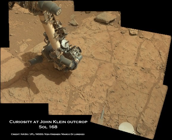
Image caption: Curiosity’s robotic arm places the robotic arm tool turret and Alpha Particle X-Ray Spectrometer (APXS) instrument on top of John Klein outcrop shown in this photo mosaic taken with the Mastcam 34 camera on Jan. 25, 2013, or Sol 168. The drill bit and prongs are pointing right on the tool turret. Credit: NASA/JPL-Caltech/MSSS/Ken Kremer/Marco Di Lorenzo

Because huge temperature swings occur on Mars every day (over 65 C or 115 F), the team needs to determine whether there is any chance of excessive stress on the arm while it is pressing the drill down onto the Martian surface. The daily temperature variations can cause rover systems like the arm, chassis and mobility system to expand and contact by about a tenth of an inch (about 2.4 millimeters), a little more than the thickness of a U.S. quarter-dollar coin.

“We don’t plan on leaving the drill in a rock overnight once we start drilling, but in case that happens, it is important to know what to expect in terms of stress on the hardware,” said Limonadi. “This test is done at lower pre-load values than we plan to use during drilling, to let us learn about the temperature effects without putting the hardware at risk.”

The high resolution MAHLI microscopic imager on the arm turret will take close-up before and after images of the outcrop target to assess the success of the drilling operation.

On Sol 175, another significant activity is planned whereby one of the ‘blank” organic check samples brought from Earth will be delivered to the SAM instrument for analysis as a way to check for any traces of terrestrial contamination of organic molecules and whether the sample handing system was successfully cleansed earlier in the mission at the Rocknest windblown sand ripple.

Meanwhile on the opposite side of Mars, NASA’s Opportunity rover starts Year 10 investigating never before touched phyllosilicate clay minerals that formed eons ago in flowing liquid water at Endeavour crater – detailed here.

Stay tuned for exciting results from NASA’s Martian sisters.

Ken Kremer

Curiosity at John Klein Sol170fa_Ken Kremer

Image caption: View to Mount Sharp from Curiosity at Yellowknife Bay and John Klein outcrop. This photo mosaic was taken with the Mastcam 34 camera on Jan. 27, 2013, or Sol 170. Credit: NASA/JPL/MSSS/ Marco Di Lorenzo/Ken Kremer

PIA16716_ip[1]

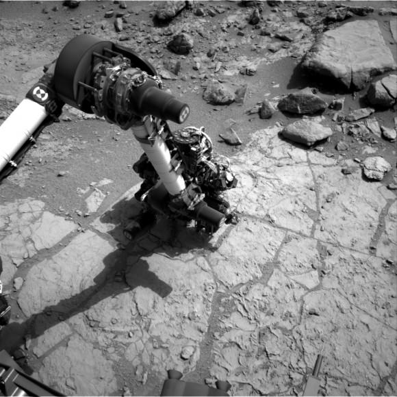
Curiosity’s Drill in Place for Load Testing Before Drilling. The percussion drill in the turret of tools at the end of the robotic arm of NASA’s Mars rover Curiosity has been positioned in contact with the rock surface in this image from the rover’s front Hazard-Avoidance Camera (Hazcam). Credit: NASA/JPL-Caltech

Curiosity & Yellowknife Bay Sol 157_4Ca_Ken Kremer

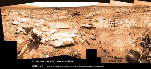
Image caption: Curiosity found widespread evidence for flowing water in the highly diverse, rocky scenery shown in this photo mosaic from the edge of Yellowknife Bay on Sol 157 (Jan 14, 2013) before driving to the John Klein outcrop at upper right. The rover then moved and is now parked at the flat rocks at the John Klein outcrop and is set to conduct historic 1st Martian rock drilling here on Jan. 31, 2013. ‘John Klein’ is filled with numerous mineral veins which strongly suggest precipitation of minerals from liquid water. Credit: NASA/JPL-Caltech/Ken Kremer/Marco Di Lorenzo

Opportunity Rover Starts Year 10 on Mars with Remarkable Science Discoveries

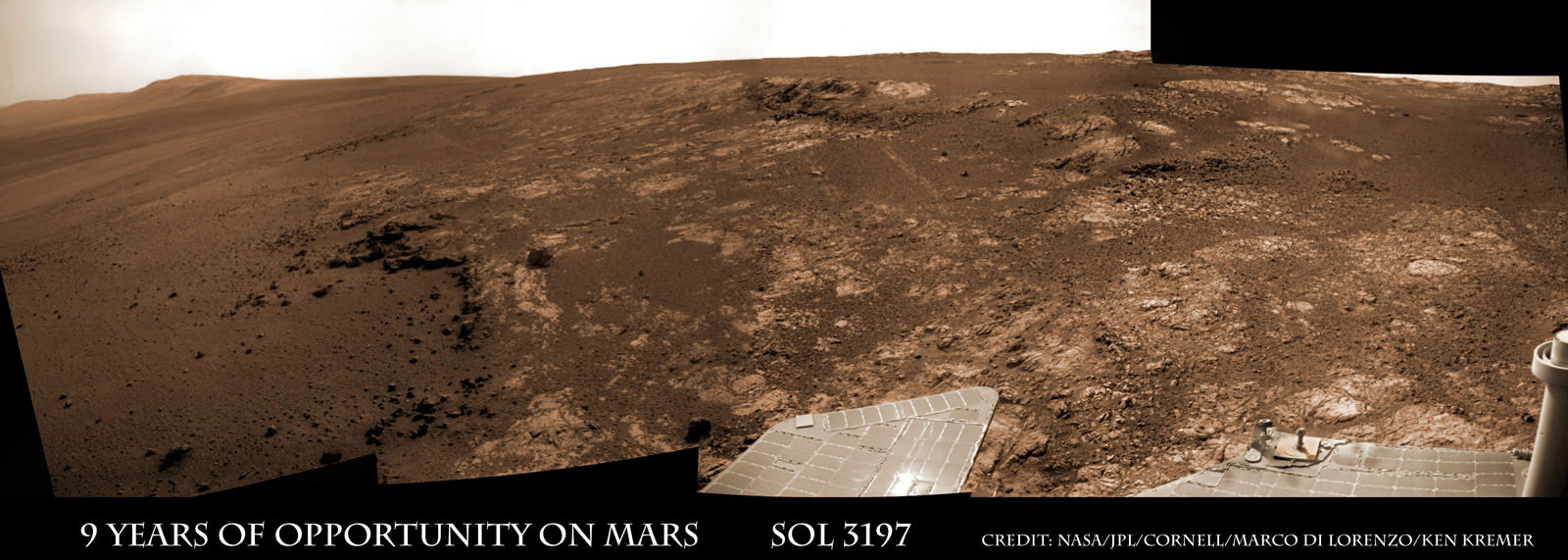
Image caption: Opportunity Celebrates 9 Years and 3200 Sols on Mars snapping this panoramic view from her current location on ‘Matijevic Hill’ at Endeavour Crater. The rover discovered phyllosilicate clay minerals and calcium sulfate veins at the bright outcrops of ‘Whitewater Lake’, at right, imaged by the Navcam camera on Sol 3197 (Jan. 20, 2013). “Copper Cliff” is the dark outcrop, at top center. Darker “Kirkwood” outcrop, at left, is site of mysterious “newberries” concretions. Credit: NASA/JPL-Caltech/Cornell/Marco Di Lorenzo/Ken Kremer

9 Years ago, NASA’s pair of identical twin sister rovers – christened Spirit & Opportunity- bounced to daunting airbag-cushioned landings on opposite sides of the Red Planet for what was supposed to be merely 90 day missions, or maybe a little bit longer scientists hoped.

Today, Opportunity celebrates a truly unfathomable achievement, starting Year 10 on Mars since she rolled to a bumpy stop on January 24, 2004 inside tiny Eagle crater. And she’s now at a super sweet spot for science (see our photo mosaic above) loaded with clays and veined minerals and making the most remarkable findings yet about the planets watery past – thus building upon a long string of previously unthinkable discoveries due to her totally unforeseen longevity.

“Regarding achieving nine years, I never thought we’d achieve nine months!” Principal Investigator Prof. Steve Squyres of Cornell University told Universe Today for this article commemorating Opportunity’s 9th anniversary.

Opportunity reached 3200 Sols, or Martian days, and counting , by her 9th birthday. She is now 108 months into the 3 month primary mission – that’s 36 times longer than the 3 month “warranty.”

“Every sol is a gift,” Squyres told me. He always refers to the rovers as our “Priceless assets on Mars”, that have to be taken good care of to wring out the maximum science data possible and for as long as humanly, or more aptly, robotically possible.
PIA16703_Sol3137B_Matijevic_Pan_L257atc_br2

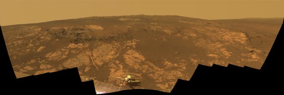
Image Caption: ‘Matijevic Hill’ Panorama for Rover’s Ninth Anniversary. As Opportunity neared the ninth anniversary of its landing on Mars, the rover was working in the ‘Matijevic Hill’ area seen in this view from Opportunity’s panoramic camera (Pancam). Two of the features investigated at Matijevic Hill are “Copper Cliff,” the dark outcrop in the left center of the image, and “Whitewater Lake,” the bright outcrop on the far right. The component images for this mosaic were taken from Sol 3137 (Nov. 19, 2012) through Sol 3150 (Dec. 3, 2012). Credit: NASA/JPL-Caltech/Cornell/Arizona State Univ.

The resilient, solar powered Opportunity robot begins her 10th year roving around beautifully Earth-like Martian terrain where where she proved that potentially life sustaining liquid water once flowed billions of years ago when the planet was warmer and wetter.

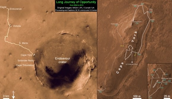
Opportunity is healthy and has driven over 22 miles (35 kilometers )- marking the first overland expedition on another planet. See our photo mosaics and route map by Ken Kremer and Marco Di Lorenzo.

She is now working at the inboard edge of “Cape York” – a hilly segment of the eroded rim of 14 mile (22 km) wide Endeavour Crater, featuring terrain with older rocks than previously inspected and unlike anything studied before. It’s a place no one ever dared dream of reaching prior to launch in the summer of 2003 and landing on the Meridiani Planum region of Mars.

“It’s like a whole new mission since we arrived at Cape York,” says Squyres.
Opportunity Sol 3182_3Ba_Ken Kremer

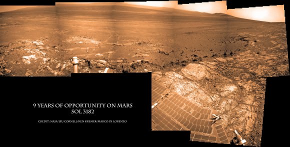
Image caption: Opportunity Celebrates 9 Years on Mars snapping this panoramic view of the vast expanse of 14 mile (22 km) wide Endeavour Crater from atop ‘Matijevic Hill’ on Sol 3182 (Jan. 5, 2013). The rover then drove 43 feet to arrive at ‘Whitewater Lake’ and investigate clay minerals. Photo mosaic was stitched from Navcam images and colorized. Credit: NASA/JPL-Caltech/Cornell/Ken Kremer/Marco Di Lorenzo

Today Opportunity is poised for breakthrough science at deposits of phyllosilicates – clay minerals which stem from an earlier epoch when liquid water flowed on Mars eons ago and perhaps may have been more favorable to sustaining microbial life because they form in more neutral pH water. Endeavour Crater is more than 3 Billion years old.

I asked Squyres to discuss the discovery of the phyllosilicates – which have never before been analyzed up close on the Martian surface and are actually a main target of NASA’s new Curiosity rover at Gale Crater.

“We have found the phyllosilicates at Cape York: they’re in the Whitewater Lake materials,” Squyres explained. Spectral data collected from Mars orbit by the CRISM spectrometer aboard NASA’s MRO circling spacecraft allowed the researchers to direct Opportunity to this exact spot.

“Whitewater Lake” is an area of bright local outcrops currently being investigated and providing information about a different and apparently less acidic environment compared to other areas and craters visited earlier in the mission – and potentially more conducive to life.

Opportunity also discovered more mineral veins at “Whitewater Lake”, in addition to those hydrated mineral veins discovered earlier at Cape York at a spot named “Homestake” – see our mosaic below.

“We have investigated the veins in these materials, and we have determined that they are calcium sulfate,” Squyres confirmed to me.
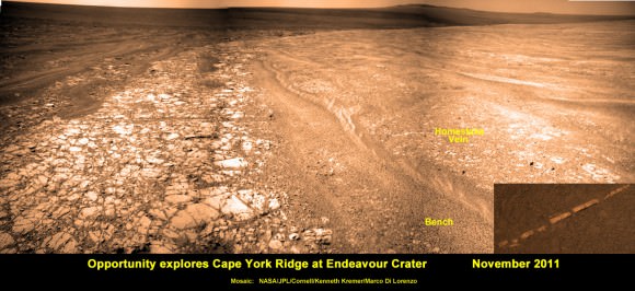
Opportunity Sol 2761_2a_Ken Kremer

Image caption: Opportunity discovers hydrated Mineral Vein at Endeavour Crater – November 2011. Opportunity determined that the ‘Homestake’ mineral vein was composed of calcium sulfate,or gypsum, while exploring around the base of Cape York ridge at the western rim of Endeavour Crater. The vein discovery indicates the ancient flow of liquid water at this spot on Mars. This panoramic mosaic of images was taken on Sol 2761, November 2011, and illustrates the exact spot of the mineral vein discovery. Featured on NASA Astronomy Picture of the Day (APOD) on 12 Dec 2011. Credit: NASA/JPL/Cornell/Kenneth Kremer/Marco Di Lorenzo.

How do the new mineral veins compare to those at ‘Homestake’ and those just found by Curiosity at Yellowknife Bay inside Gale crater? I asked Sqyures.

“Much narrower, and possibly older,” he said compared to the Homestake calcium sulfate veins .

“It’s too early to say how they compare to the veins at Gale, though.”

The local area at “Cape York” is called “Matijevic Hill” – in honor of a recently deceased team member who played a key role on NASA’s Mars rovers.

The rover has already spent a few months at “Matijevic Hill” on a ‘walk about’ scouting survey and also found concretions dubbed “newberries” that are different from the “blueberry” concretions found earlier in the mission.

How widespread are the phyllosilicates ?

“Matijevic Hill is the only exposure of phyllosilicates we know of at Cape York, so in order to find more we’re going to have to go elsewhere,” Squyres replied. “We haven’t figured out what the “newberries” are yet, but attempting to do that will be our next task.”

It is likely to take many more weeks and even months to “figure out” what this all means for science.

Therefore, no one should expect the robot to move much in the near future. Since the rover made landfall at the western rim of Endeavour crater at Spirit Point in August 2011, she has been circling around Cape York ever since.
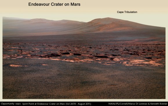
Opportunity Sol 2678c_Ken Kremer

Image caption: Opportunity rover first arrived at the western rim of Endeavour Crater (14 miles, 22 km wide) in August 2011. This photo mosaic of navcam images shows portions of the segmented rim of Endeavour crater on Sol 2678. Large ejecta blocks from a smaller nearby crater are visible in the middle. At Endeavour, Opportunity will investigate the oldest minerals deposits she has ever visited from billions of years ago and which may hold clues to environments that were potentially habitable for microbial life. The rover may eventually drive to Cape Tribulation at right if she survives. Credit: NASA/JPL/Cornell/Marco Di Lorenzo/Ken Kremer (kenkremer.com)

What is the next destination for Opportunity?

“Once we’re done at Cape York, our next destination will be Solander Point [to the south],” Squyres confirmed. It’s the next rim segment south of Cape York (see map).

Eventually, if Opportunity continues to function and survives the next Martian winter, she may be directed several miles even further south, along the crater rim to a spot called Cape Tribulation – because it also harbors caches of phyllosilicate clay minerals. But there is no telling when that might be.

“One step at a time,” said Squyres as always. He is not making any guesses or predictions. The mission is totally discovery driven.

Well after so many great science discoveries over the past 9 years, I asked Squyres to describe the context and significance of the phyllosilicates discovery?

“Impossible to say, I’m afraid… we’re still figuring this place out; I can’t put it in context yet,” Squyres concluded.

Thus, there is still so much more bountiful science research still to be done by Opportunity – and nobody is making any forecasts on how long she might yet survive.

So just keep praying to the Martian weather gods for occasional winds and “dust devils” to clean off those life giving solar panels – and to the US Congress to provide the essential funding.

Ken Kremer
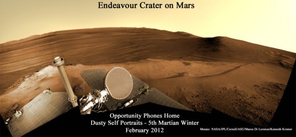
Opportunity Sol 2852a_Ken Kremer

Image caption: Opportunity Phones Home – Dusty Self Portrait from Endeavour Crater on Mars on Sol 2852, February 2012. NASA’s rover Opportunity snaps self-portrait where she endured 5th frigid Martian winter at Greeley Haven. Opportunity is currently investigating Cape York ridge and Matijevic Hill at right. Vast expanse of Endeavour Crater and rim in background with dusty solar panels and full on view of the High Gain Antenna (HGA) in the foreground. Mosaic: NASA/JPL/Cornell/ASU/Marco Di Lorenzo/Ken Kremer
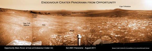
Opportunity Sol 2681a_annotated_Ken Kremer

Image caption: Endeavour Crater Panorama from Opportunity, Sol 2681, August 2011 on arrival at the rim of Endeavour and Cape York ridge. Odyssey crater visible at left. Mineral veins were later found to surround Cape York. Credit: NASA/JPL/Cornell/Marco Di Lorenzo/Ken Kremer
Opportunity Route map_3187s_Ken Kremer

Image caption: Traverse Map for NASA’s Opportunity rover from 2004 to 2013 – shows the entire path the rover has driven over 9 years, 3200 Sols and more than 22 miles (35 km) from Eagle Crater landing site to current location at Cape York ridge at Endeavour Crater. Credit: NASA/JPL/Cornell/ASU/Marco Di Lorenzo/Ken Kremer (kenkremer.com)
Curiosity Touches Mars at Yellowknife Bay and Drives to Snake River for Drilling

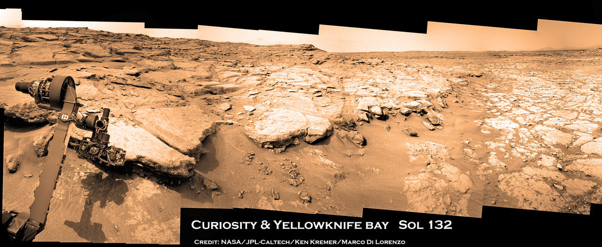
Image Caption: Photo mosaic shows NASA’s Curiosity Mars rover in action reaching out to investigate rocks at a location called Yellowknife Bay on Sol 132, Dec 19, 2012 in search of first drilling target. The view is reminiscent of a dried up shoreline. Curiosity’s navigation camera captured the scene surrounding the rover with the arm deployed and the APXS and MAHLI science instruments on tool turret collecting microscopic imaging and X-ray spectroscopic data. The mosaic is colorized. See the full 360 degree panoramic and black & white versions below. Credit: NASA/JPL-Caltech/Ken Kremer/Marco Di Lorenzo

Following the Christmas season break for panoramic imaging of her surroundings, NASA’s Curiosity robot has resumed roving around the shallow depression she reached before the holidays called ‘Yellowknife Bay’ and just arrived at a slithery rock called ‘Snake River’.

The top priority is to locate a target rock to drill into – and that momentous event could at last take place in the next week or so. The drill is the last of Curiosity’s suite of ten science instruments to be fully checked out and commissioned for use.

The drilling scene will look a lot like our photo mosaics, above and below, showing the robotic arm deployed for action. The drill is located on the tool turret at the end of the 7 foot (2.1 meter) long mechanical marvel.

The Curiosity research team is using the newly collected cache of high resolution color images to scan her surroundings in search of scientifically interesting rocks for the historic inaugural use of the high powered hammering drill.

Curiosity touches Yellowknife Bay Sol 132_4c_Ken Kremer

Image Caption: Photo mosaic shows NASA’s Curiosity Mars rover in action reaching out to investigate rocks at a location called Yellowknife Bay on Sol 132, Dec 19, 2012. In search of first drilling target the rover drove to a spot at the right edge of this mosaic called Snake River rock. Curiosity’s navigation camera captured the scene surrounding the rover with the arm deployed and the APXS and MAHLI science instruments on tool turret collecting imaging and X-ray spectroscopic data. Base of Mount Sharp visible at right.The mosaic is colorized with patches of sky added to fill in gaps. Click to enlarge. Credit: NASA/JPL-Caltech/Ken Kremer/Marco Di Lorenzo

The percussive drill will collect the first ever powdered samples from the interior of Martian rocks for analysis by a pair of state-of-the-art analytical chemistry instruments located inside the rover named SAM and CheMin.

“We are firing on all cylinders now and our last thing to do is drilling, and we really hope to start on that process beginning next week,” said John Grotzinger, the mission’s chief scientist of the California Institute of Technology, in an interview with Jonathan Amos of the BBC.

The rover is also using the APXS X-ray mineral spectrometer, ChemCam rock blasting laser and MAHLI hand lens imager to gather science characterization data helpful in choosing the drill target.

Today (Jan. 5) marks exactly 5 months since Curiosity’s hair-raisingly successfully touchdown on Aug. 5, 2012 on the gravelly plains of Gale Crater beside the towering foothills of Mount Sharp, a 3 mi (5 km) high layered mountain holding deposits of hydrated minerals. Mount Sharp is the main destination of Curiosity’s mission.

On Jan. 3 (Sol 147), Curiosity drove another 10 feet (3 meters) northwestward and pulled up to a sinuous rock feature called “Snake River” as part of a campaign to survey a variety of rocks from which to select the drilling site.

“It’s one piece of the puzzle,” says John Grotzinger. “It has a crosscutting relationship to the surrounding rock and appears to have formed after the deposition of the layer that it transects.”

717343main_pia16564-43_946-710

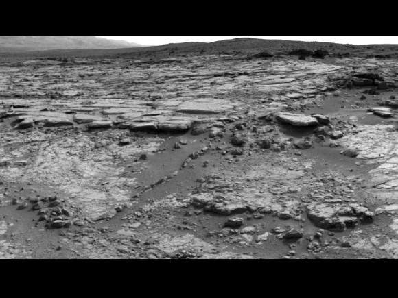
‘Snake River’ sinuous Rock Feature Viewed by Curiosity Mars Rover on Sol 133. On Sol 147 (Jan 3. 2013), the rover drove to within arm’s reach of Snake river for up close examination as possible drill target. Credit: NASA/JPL-Caltech

Snake River is a thin curving line of darker rock cutting through flatter rocks and jutting above sand, says NASA. It’s located at the right side edge of our Sol 132 photo mosaic stitched together from raw images by the image processing team of Ken Kremer & Marco Di Lorenzo to provide a context view of the scenery – and were also featured at NBC News by Alan Boyle, BBC News, NASA Watch and the NY Daily News.

So far the robot has driven a total of 2,303 feet (702 meters) and snapped nearly 36,000 pictures.

Yellowknife Bay is a basin inside an area dubbed ‘Glenelg’ that features a flatter and lighter-toned type of terrain from what the mission crossed during its first four months inside Gale Crater. The rover descended about 2 feet (0.5 m) down a slight incline to reach the inside of the depression in December 2012.

“We’re down at the very lowest layer – what would be the oldest layer that we would see in this succession that might be five to eight meters thick, and that is very likely where we are going to choose our first drilling target, because suddenly we’ve come into an area that represents a very high diversity of things we haven’t seen before,” said Grotzinger to the BBC.

“The place where Curiosity is right now is a small stack of layers – very impressive – and they could be 3-3.5 billion years old, and so we’re very excited about this because unlike the soil which we were analyzing before the holiday season – a loose, windswept patch of dirt on the surface of Mars – we’re now going to start digging down into the very ancient bedrock which we really built the rover to look at,” explained Grotzinger.

Curiosity & Yellowknife Bay Sol 125_2c_Ken Kremer

Image caption: Curiosity peaks around Yellowknife Bay on Sol 125, Dec 12, 2012. The rover has continued driving inside the basin in search of 1st rock drill target in Jan 2013. Credit: NASA/JPL-Caltech/Ken Kremer/Marco Di Lorenzo

The mission goal is to search for habitats and determine if Mars ever could have supported microbial life in the past or present during the 2 year primary mission phase.

“We use these layers as a sort of recording device of past events and conditions, and the rover has the same kind of analytical capability that we would use here on Earth to tell us about the early environmental conditions; and, if life had ever evolved, [whether it would] be the kind of environment that would have been conducive towards sustaining that life,” Grotzinger elaborated to the BBC.

Stay tuned.

Ken Kremer

Curiosity touches Yellowknife Bay Sol 132_3c_Ken Kremer

Image Caption: Photo mosaic shows NASA’s Curiosity Mars rover in action reaching out to investigate rocks at a location called Yellowknife Bay on Sol 132, Dec 19, 2012. Credit: NASA/JPL-Caltech/Ken Kremer/Marco Di Lorenzo

Curiosity Celebrates 1st Martian Christmas at Yellowknife Bay

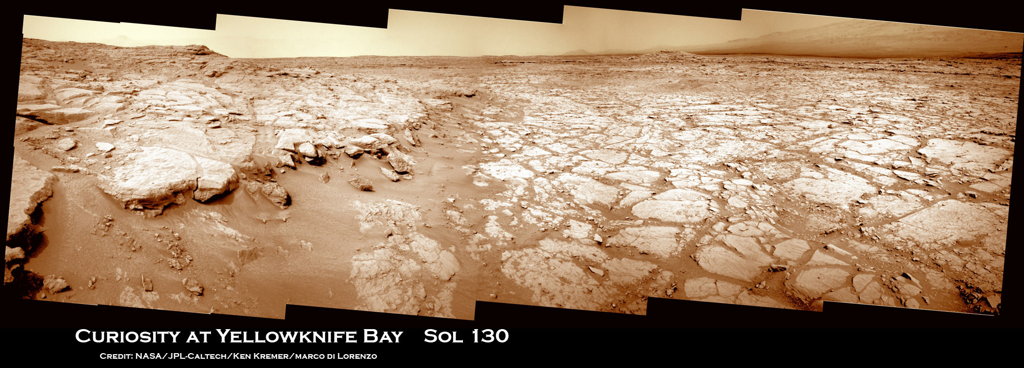
Image Caption: Curiosity Scans ‘Yellowknife Bay’ on Sol 130. NASA’s Curiosity rover celebrated her 1st Christmas on the Red Planet at ‘Yellowknife Bay’ and is searching for her 1st rock target to drill into for a sample to analyze. She snapped this panoramic view on Dec. 17 which was stitched together from navigation camera (Navcam) images. Credit: NASA/JPL-Caltech/Ken Kremer/Marco Di Lorenzo

Today (Dec. 25) Curiosity celebrates her 1st Christmas on Mars at a spot called ‘Yellowknife Bay’. It’s Sol 138 and nearly 5 months since the pulse pounding landing on Aug. 6, 2012 inside Gale Crater. The robot is in excellent health.

Meanwhile her older sister Opportunity will soon celebrate an unfathomable 9 Earth years on Mars in a few short weeks on Jan. 24, 2013 – on the other side of the planet.

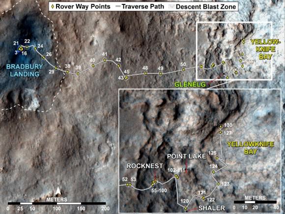
NASA’s Curiosity rover reached the shallow depression named ‘Yellowknife Bay’ on Sol 130 (Dec. 17, 2012) after descending about 2 feet (0.5 m) down a gentle slope inside a geologic feature dubbed ‘Glenelg’. See our panoramic mosaics from Yellowknife Bay – above and below for a context view.

The science team is searching for an interesting rock for the inaugural use of the high powered hammering drill.

According to a new report in SpaceRef, the drilling has been delayed due to concerns that frictional heating may potentially cause liquification of the rock to a gooey “Martian Honey” that could potentially clog and seriously damage the sample handling sieves and mechanisms. So the team is carefully re-evaluating the type of rock target and the drilling operation procedures before committing to the initial usage of the percussive drill located on the turret at the terminus of the robotic arm.

The team chose to drive to ‘Yellowknife Bay’ because it features a different type of geologic terrain compared to what Curiosity has driven on previously. The ‘Glenelg’ area lies at the junction of three different types of geologic terrain and is Curiosity’s first extended science destination.

Curiosity arrived at the lip of Yellowknife Bay on Sol 124 and entered the basin on Sol 125 (Dec. 12) and snapped a scouting panoramic view peering into the inviting locale. The rover is also using the APXS X-ray mineral spectrometer, ChemCam laser and MAHLI hand lens imager to gather initial science characterization data.

Curiosity peaks around Yellowknife Bay on Sol 125, Dec 12, 2012. The rover continued driving inside the basin in search of 1st rock drill target. Credit: NASA/JPL-Caltech/Ken Kremer/Marco Di Lorenzo

So far the rover has traversed a total driving distance of some 0.43 mile (700 meters).

Most of the science and engineering team is getting a much needed break to spend time with their families after uploading 11 Sols worth of activities ahead of time to keep the robot humming during the Christmas holiday season. A skeleton crew at JPL is keeping watch to deal with any contingencies.

One of the top priorities is acquiring a high resolution 360 degree Mastcam color panorama. This will be invaluable for selection of the very 1st rock target to drill into and acquire a sample from the interior – a feat never before attempted on Mars.

“We decided to drive to a place with a good view of the outcrops surrounding Yellowknife Bay to allow good imaging of these outcrops before the holiday break,” says rover science team member Ken Herkenhoff. “As the images are returned during the break, we can use them to help decide where to perform the first drilling operation.”

The team expects to choose a drill target sometime in January 2013 after a careful selection process.

The 7 foot (2 m) long robotic arm will deliver that initial, pulverized rock sample to inlet ports on the rover deck for analysis by the high powered duo of miniaturized chemistry labs named Chemin & SAM.

Image Caption: Curiosity deploys robotic arm on Sol 129 and examines rock with APXS and MAHLI science instruments to characterize rock and soil composition. This composite mosaic was stitched from Navcam images from Sol 129 (Dec. 16) and earlier sols- and shows the location of the Chemin sample inlet port on the rover deck. Credit: NASA/JPL-Caltech/Ken Kremer/Marco Di Lorenzo

Curiosity will spend at least another month or more investigating Glenelg before setting off on the nearly year long trek to her main destination – the sedimentary layers of the lower reaches of the 3 mile (5 km) high mountain named Mount Sharp.

Image caption: Scanning Mount Sharp from Yellowknife Bay on Sol 136. This photo mosaic assembled from Mastcam 100 camera images was snapped by Curiosity on Sol 136 (Dec. 23) – from her current location. It shows a portion of the layered mound called Mount Sharp, her main destination. Acquiring a 360 high resolution color panorama from Yellowknife Bay is a high priority task for the rover during the Christmas holiday season. Credit: NASA/JPL-Caltech/Marco Di Lorenzo/Ken Kremer

As the Martian crow flies, the breathtaking environs of Mount Sharp are some 6 miles (10 km) away.

The mission goal is to search for habitats and determine if Mars ever could have supported microbial life in the past or present during the 2 year primary mission phase.

Ken Kremer

Image Caption: Curiosity Traverse Map, Sol 130. This map traces where Curiosity drove between landing at a site named “Bradbury Landing,” and the position reached during Sol 130 (Dec. 17, 2012) at a spot named “Yellowknife Bay” which is inside an area called “Glenelg”. The inset shows the most recent legs of the traverse in greater detail. Credit: NASA/JPL-Caltech/Univ. of Arizona

Vote ‘Curiosity’ as TIME Person of the Year

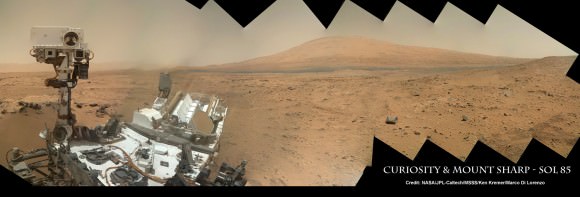
I Need You ! Vote for ‘Curiosity’ as TIME magazine Person Of The Year. NASA’s new Curiosity Mars rover snapped this Head and Shoulders Self-Portrait on Sol 85 (Nov. 1 , 2012) as Humanity’s emissary to the Red Planet in Search of Signs of Life. Mosaic Credit: NASA/JPL-Caltech/MSSS/Ken Kremer/Marco Di Lorenzo

Caption – I Need You ! Vote for ‘Curiosity’ as TIME magazine Person Of The Year.
NASA’s new Curiosity Mars rover snapped this Self-Portrait on Sol 85 (Nov. 1 , 2012) as Humanity’s emissary to the Red Planet in Search of Signs of Life. Mosaic Credit: NASA/JPL-Caltech/MSSS/Ken Kremer/Marco Di Lorenzo

You can make it happen. Vote Now ! Vote Curiosity !

Vote for ‘Curiosity’ as the Time magazine Person of the Year

Make your voice heard – Help send a message to the Feds to “Save Our Science” as the Fiscal Cliff nears and threatens our Science.

Perhaps you are a doubter. Well think again. Because at this moment NASA’s Curiosity Mars rover has thrust forward into 5th Place, inching ahead of – comedian Stephen Colbert, according to the running tally at TIME’s Person of the Year website.

NASA’s SUV-sized Curiosity Mars rover is the most powerful science robot ever dispatched as Humanity’s emissary to the surface of the Red Planet. She is searching for Signs of Life and may shed light on the ultimate questions – “Are We Alone?” – “Where do We fit In?

Curiosity is NASA’s first Astrobiology mission to Mars since the twin Viking landers of the 1970’s.

TIME’s editors are soliciting your input on worthy candidates for Person of the Year, although they will choose the ultimate winner.

You have until 11:59 p.m. on Dec. 12 to cast your vote. The winner of the people’s choice will be announced on Dec. 14. The magazine itself with the ultimate winner appears on newsstands on Dec. 21

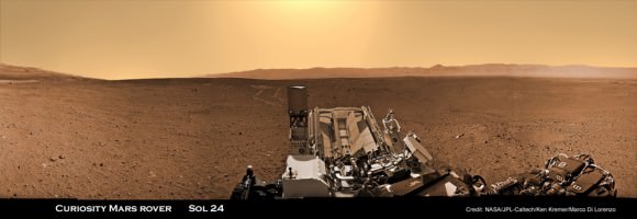
Image caption: Curiosity trundling across Mars surface inside Gale Crater on Sol 24 (Aug. 30, 2012). Colorized mosaic stitched together from Navcam images. This panorama is featured on PBS NOVA ‘Ultimate Mars Challenge’ documentary which premiered on PBS TV on Nov. 14. Credit: NASA / JPL-Caltech / Ken Kremer / Marco Di Lorenzo

Read TIME’s statement about voting for Curiosity:

You may own a cool car — you may even own a truly great car — but it’s a cinch that no matter how fantastic it is, it can never be anything more than the second best car in the solar system. The greatest of all is the Mars Curiosity rover, one ton of SUV-size machine now 160 million miles from Earth and trundling across the Martian surface. It was the rover’s landing on Mars last August that first caught people’s eyes: an improbable operation that required a hovering mother ship to lower the rover to the surface on cables like a $2.5 billion marionette. But it’s the two years of exploration Curiosity has ahead of it — with a suite of instruments 10 times as large as any ever carried to Mars before — that will make real news. NASA built the country one sweet ride, and yes, alas, it’s sweeter than yours.

Cast your vote for Curiosity now, and avoid the long lines – before it’s too late

Ken Kremer

…..

Learn more about Curiosity’s groundbreaking discoveries and NASA missions at my upcoming pair of free presentations for the general public at two colleges in New Jersey:

Dec 6: Free Public lecture titled “Atlantis, The Premature End of America’s Shuttle Program and What’s Beyond for NASA” including Curiosity, Orion, SpaceX and more by Ken Kremer at Brookdale Community College/Monmouth Museum and STAR Astronomy club in Lincroft, NJ at 8 PM

Dec 11: Free Public lecture titled “Curiosity and the Search for Life on Mars (in 3 D)” and more by Ken Kremer at Princeton University and the Amateur Astronomers Association of Princeton (AAAP) in Princeton, NJ at 8 PM – Princeton U Campus at Peyton Hall, Astrophysics Dept.

Is Historic Discovery imminent concerning Martian Organic Chemistry ?

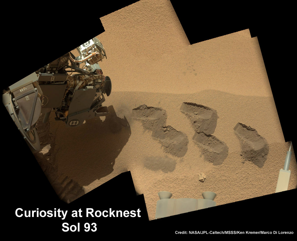
Image caption: Curiosity scoops repeatedly into this Martian soil at windblown ripple dubbed ‘Rocknest’, shown in this mosaic, and delivered samples to the SAM chemistry instrument, on the robots deck, to search for any signatures of organic molecules – the building blocks of life. This color mosaic was stitched together from hi-res color images taken by the robots 34 mm Mastcam camera on Sols 93 and 74. Credit: NASA / JPL-Caltech / MSSS/Ken Kremer / Marco Di Lorenzo

Has Curiosity made a ‘Historic’ science discovery with the SAM (Sample Analysis at Mars) chemistry instrument that analyzes Martian soil (see mosaic above) and is designed to detect organic molecules – the building blocks of life? Has Curiosity unambiguously and directly detected the first signatures of organics on Mars ? Is an announcement imminent?

Speculation is rampant that NASA’s Curiosity Mars rover has made an earth-shaking discovery ‘for the history books’ , following a radio interview by NPR’s Joe Palca with the mission’s Principal Investigator, John Grotzinger, while sitting in his office at Caltech last week. NPR reported the story on Tuesday, Nov. 20.

“We’ve got a briefing on Monday [Dec 3] where we’ll discuss our results,” John Grotzinger told me.

Grotzinger will describe the SAM data and their potentially pivotal implications at the annual meeting of the AGU (American Geophysical Union) being held from Dec 3-7 in San Francisco. Many papers and results from the first three months of the Curiosity Mars Science Lab (MSL) mission will be presented at the AGU meeting.

“The science team is analyzing data from SAM’s soil inspection, but not ready to discuss yet,” JPL Press spokesman Guy Webster informed me today.

It’s the Thanksgiving holiday period here in the US so the answers will wait a tad longer.


Image Caption: Curiosity Self Portrait with Mount Sharp at Rocknest ripple in Gale Crater. Curiosity used the Mars Hand Lens Imager (MAHLI) camera on the robotic arm to image herself and her target destination Mount Sharp in the background.SAM chemistry suite located on robot’s deck near Mast. To the left is the northern rim wall of Gale Crater. This color panoramic mosaic was assembled from raw images snapped on Sol 85 (Nov. 1, 2012). Credit: NASA/JPL-Caltech/MSSS/Ken Kremer/Marco Di Lorenzo

Curiosity had been collecting and analyzing Martian soil samples for more than a month at a windblown ripple called ‘Rocknest’. So far Curiosity has scooped into the Martian soil five times and delivered a single sample to SAM and two to the adjacent CheMin chemistry instrument.

“This data is gonna be one for the history books,” Grotzinger went on to say to NPR. “It’s looking really good.”

JPL Press spokesman Guy Webster advises caution and patience while damping down euphoria. He told me that the team is still trying to interpret and understand the analysis from SAM and seeking to clarify their meaning before making any premature conclusions.

“This is no change from the policy with past results from the mission, such as SAM’s atmosphere analysis or CheMin’s soil sample analysis: The scientists want to gain confidence in the findings before taking them outside of the science team,” Webster informed me.

“As for history books, the whole mission is for the history books. John was delighted about the quality and range of information coming in from SAM during the day a reporter happened to be sitting in John’s office last week. He has been similarly delighted by results at other points during the mission so far,” Webster said.

Organic molecules are the basis for life as we know it, and they have never before been discovered on the Red Planet’s surface. I am an organic chemist and to me the detection of organics on Mars would indeed be “Earth-shaking”. But just a finding of organics alone does NOT mean we discovered life. Organics are a prerequisite to life. Life requires finding much more complex molecules, like amino acids and far more beyond that.

Furthermore, finding signatures of organics so close to the surface might be a surprising result when one recalls that highly destructive ionizing radiation bombards the Martian topsoil 24/7.

So, it’s wise for the MSL team to be abundantly cautious and recheck their results multiple times. They wisely waited for further data before prematurely announcing the discovery of Martian methane. Initial SAM atmospheric measurements detecting methane turned out to be false – they actually originated from contamination by residual traces of Florida air trapped in the interior chambers of SAM and were carried all the way to Mars.

If organics are detected in the dusty dunes at Rocknest, the implications could be vast and potentially point to their widespread distribution across Gale crater and beyond.

As renowned astronomer Carl Sagan once said; ‘Extraordinary claims require extraordinary evidence.”

Stay tuned.

Learn more about Curiosity’s groundbreaking discoveries, SAM and NASA missions at my upcoming free public presentations:

Ken Kremer

…..

Dec 6: Free Public lecture titled “Atlantis, The Premature End of America’s Shuttle Program and What’s Beyond for NASA” including Curiosity, Orion, SpaceX and more by Ken Kremer at Brookdale Community College/Monmouth Museum and STAR Astronomy club in Lincroft, NJ at 8 PM

Dec 11: Free Public lecture titled “Curiosity and the Search for Life on Mars (in 3 D)” and more by Ken Kremer at Princeton University and the Amateur Astronomers Association of Princeton (AAAP) in Princeton, NJ at 8 PM.