NASA Discovers Salty Liquid Water Flows Intermittently on Mars Today, Bolstering Chance for Life

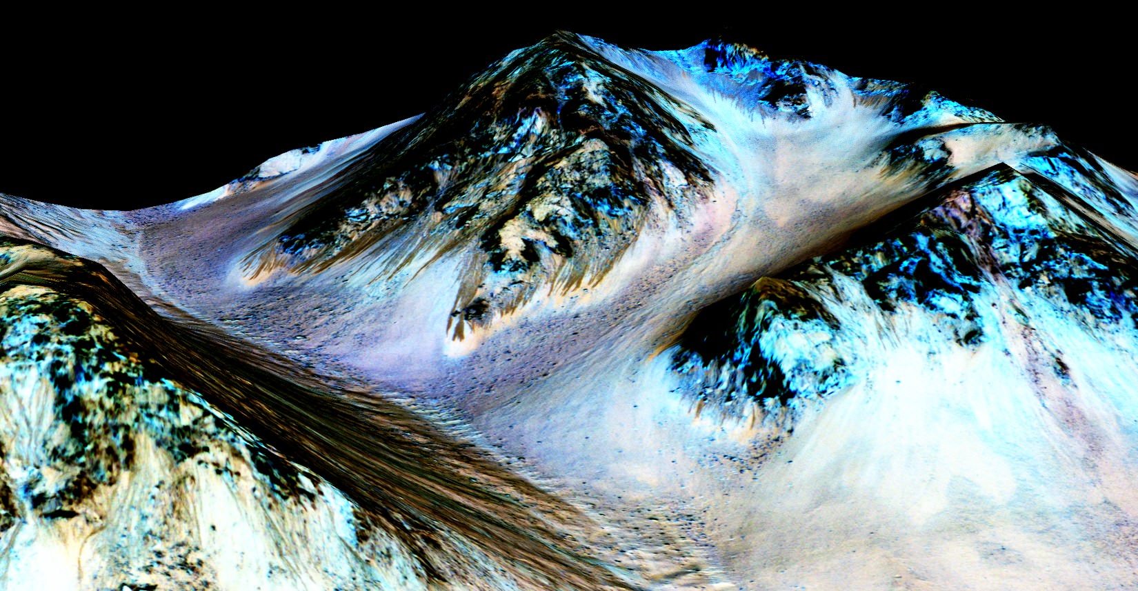
These dark, narrow, 100 meter-long streaks called recurring slope lineae flowing downhill on Mars are inferred to have been formed by contemporary flowing water. However, a new study by planetary scientists indicates that these may actually be the result of dry flows. Credits: NASA/JPL/University of Arizona

These dark, narrow, 100 meter-long streaks called recurring slope lineae flowing downhill on Mars are inferred to have been formed by contemporary flowing water. Recently, planetary scientists detected hydrated salts on these slopes at Hale crater, corroborating their original hypothesis that the streaks are indeed formed by liquid water. The blue color seen upslope of the dark streaks are thought not to be related to their formation, but instead are from the presence of the mineral pyroxene.

The image is produced by draping an orthorectified Infrared-Red-Blue/Green(IRB)) false color image on a Digital Terrain Model (DTM). This model was produced by researchers at the University of Arizona, much like the High Resolution Imaging Science Experiment (University of Arizona). The vertical exaggeration is 1.5.

NASA and Mars planetary scientists announced today (Sept. 28) that salty “liquid water flows intermittently” across multiple spots on the surface of today’s Mars – trumpeting a major scientific discovery with far reaching implications regarding the search for life beyond Earth and bolstering the chances for the possible existence of present day Martian microbes.

Utilizing spectroscopic measurements and imaging gathered by NASA’s Mars Reconnaissance Orbiter (MRO), researchers found the first strong evidence confirming that briny water flows on the Red Planet today along dark streaks moving downhill on crater slopes and mountain sides, during warmer seasons.

“Mars is not the dry, arid planet that we thought of in the past. Today we announce that under certain circumstances, liquid water has been found on Mars,” said Jim Green, NASA Planetary Science Director at NASA Headquarters, at a media briefing held today, Sept 28.

“When you look at Earth, water is an essential ingredient. Everywhere we go where there’s liquid water, whether its deep in the Earth or in the arid regions, we find life. This is tremendously exciting.”

“We haven’t been able to answer the question – does life exist beyond Earth? But following the water is a critical element of that. We now have great opportunities to be in the right locations on Mars to thoroughly investigate that,” Green elaborated.

“Water! Strong evidence that liquid water flows on present-day Mars,” NASA officials tweeted about the discovery.

The evidence comes in the form of the detection of mysterious dark streaks, as long as 100 meters, showing signatures of hydrated salt minerals periodically flowing in liquid water down steep slopes on the Red Planet that “appear to ebb and flow over time.”

The source of the water is likely from the shallow subsurface or possibly absorbed from the atmosphere.
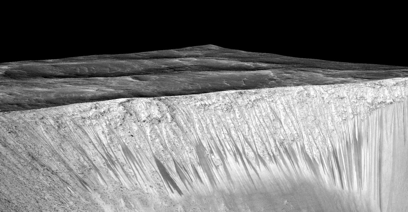
Dark narrow streaks called recurring slope lineae emanating out of the walls of Garni crater on Mars. The dark streaks here are up to few hundred meters in length. They are hypothesized to be formed by flow of briny liquid water on Mars. The image is produced by draping an orthorectified (RED) image (ESP_031059_1685) on a Digital Terrain Model (DTM) of the same site produced by High Resolution Imaging Science Experiment (University of Arizona). Vertical exaggeration is 1.5.    Credits: NASA/JPL/University of Arizona
Dark narrow streaks called recurring slope lineae emanating out of the walls of Garni crater on Mars. The dark streaks here are up to few hundred meters in length. They are hypothesized to be formed by flow of briny liquid water on Mars. The image is produced by draping an orthorectified (RED) image (ESP_031059_1685) on a Digital Terrain Model (DTM) of the same site produced by High Resolution Imaging Science Experiment (University of Arizona). Vertical exaggeration is 1.5. Credits: NASA/JPL/University of Arizona

Water is a key prerequisite for the formation and evolution of life as we know it. So the new finding significantly bolsters the chances that present day extant life could exist on the Red Planet.

“Our quest on Mars has been to ‘follow the water,’ in our search for life in the universe, and now we have convincing science that validates what we’ve long suspected,” said John Grunsfeld, astronaut and associate administrator of NASA’s Science Mission Directorate in Washington.

“This is a significant development, as it appears to confirm that water — albeit briny — is flowing today on the surface of Mars.”

“This increases the chance that life could exist on Mars today,” noted Grunsfeld.

The data were gathered by and the conclusions are based on using two scientific instruments – the high resolution imaging spectrometer on MRO known as High Resolution Imaging Science Experiment (HiRISE), as well as MRO’s mineral mapping Compact Reconnaissance Imaging Spectrometer for Mars (CRISM).

The mysterious dark streaks of downhill flows are known as recurring slope lineae (RSL).

They were first detected in 2010 at dozens of sites on the sun facing slopes of deep craters by Lujendra Ojha, then a University of Arizona undergraduate student.

The new finding is highly significant because until today’s announcement, there was no strong evidence that liquid water could actually exist on the Martian surface because the atmospheric pressure was thought to be far too low – its less than one percent of Earth’s.

The flow of water is occasional and not permanent, seasonally variable and dependent on having just the right mix of atmospheric, temperature and surface conditions with salt deposits on Mars.

Portions of Mars were covered with an ocean of water billions of years ago when the planet was far warmer and more hospitable to life. But it underwent a dramatic climate change some 3 billion years ago and lost most of that water.

The RSL with flowing water appear in at least three different locations on Mars – including Hale crater, Horowitz crater and Palikir crater – when temperatures are above minus 10 degrees Fahrenheit (minus 23 Celsius). They appear during warm seasons, fade in cooler seasons and disappear during colder times.

Pure surface water ice would simply sublimate and evaporate away as the temperature rises. Mixing in surface salts lowers the melting point of ice, thereby allowing the water to potentially liquefy on Mars surface for a certain period of time rather than sublimating rapidly away.

“These are dark streaks that form in late spring, grow through the summer and then disappear in the fall,” said Michael Meyer lead scientist for the Mars Exploration Program at NASA Headquarters, at the media briefing.

Years of painstaking effort and laboratory work was required to verify and corroborate the finding of flowing liquid water.

“It took multiple spacecraft over several years to solve this mystery, and now we know there is liquid water on the surface of this cold, desert planet,” said Meyer. “It seems that the more we study Mars, the more we learn how life could be supported and where there are resources to support life in the future.”
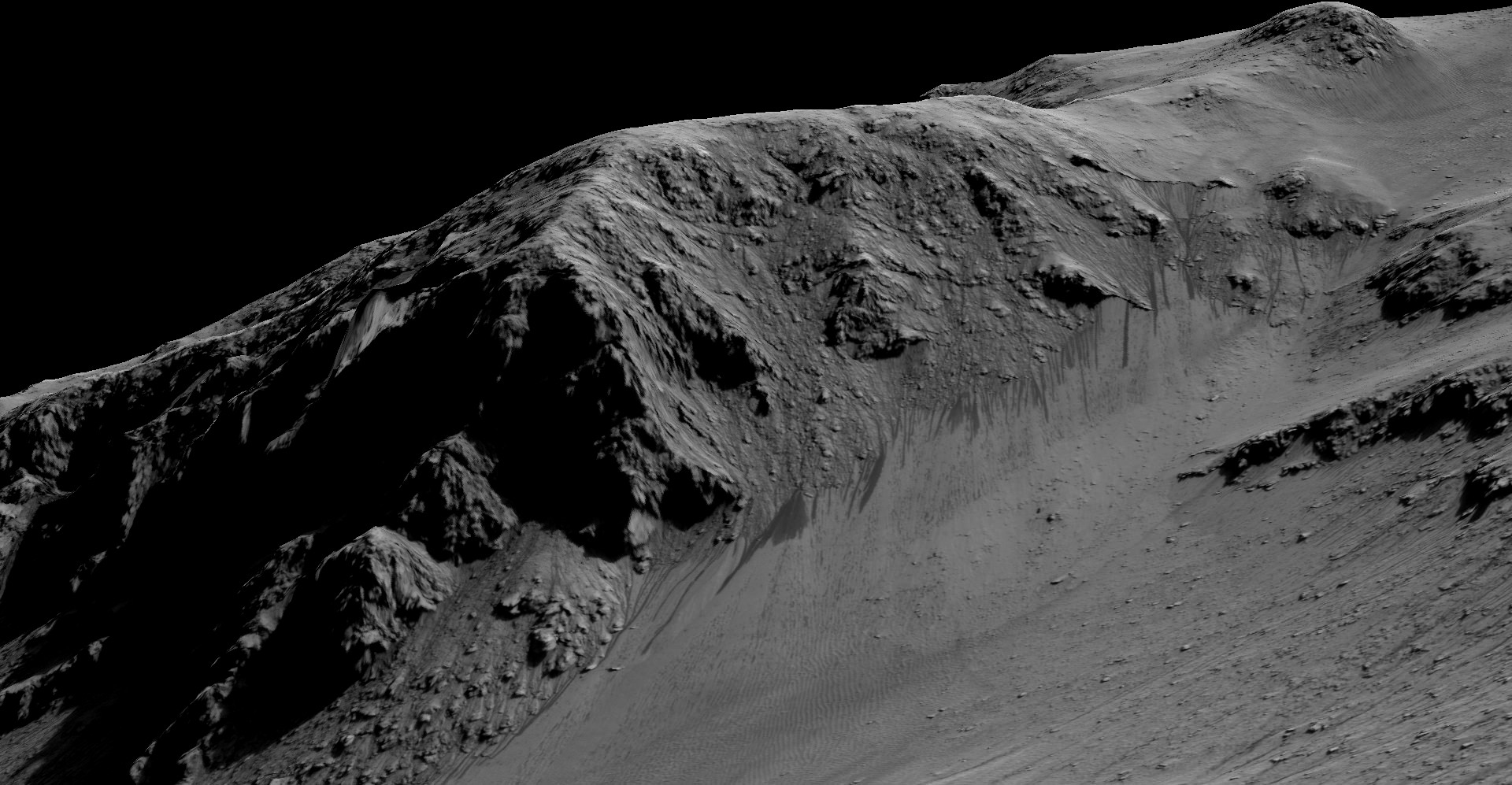
The dark, narrow streaks flowing downhill on Mars at sites such as this portion of Horowitz Crater are inferred to be formed by seasonal flow of water on modern-day Mars. The streaks are roughly the length of a football field. These dark features on the slopes are called "recurring slope lineae" or RSL. The imaging and topographical information in this processed view come from the High Resolution Imaging Science Experiment (HiRISE) camera on NASA's Mars Reconnaissance Orbiter.   Credit: NASA/JPL-Caltech/Univ. of Arizona
The dark, narrow streaks flowing downhill on Mars at sites such as this portion of Horowitz Crater are inferred to be formed by seasonal flow of water on modern-day Mars. The streaks are roughly the length of a football field. These dark features on the slopes are called “recurring slope lineae” or RSL. The imaging and topographical information in this processed view come from the High Resolution Imaging Science Experiment (HiRISE) camera on NASA’s Mars Reconnaissance Orbiter. Credit: NASA/JPL-Caltech/Univ. of Arizona

Along with the media announcement, the researchers published their findings today in a refereed scientific paper in the Sept. 28 issue of Nature Geoscience.

“We found the hydrated salts only when the seasonal features were widest, which suggests that either the dark streaks themselves or a process that forms them is the source of the hydration. In either case, the detection of hydrated salts on these slopes means that water plays a vital role in the formation of these streaks,” said Lujendra Ojha, now at the Georgia Institute of Technology (Georgia Tech) in Atlanta, and lead author of the Sept. 28 publication in Nature Geoscience.

The scientists “interpret the spectral signatures as caused by hydrated minerals called perchlorates.”

Ojha said the chemical signatures from CRISM were most consistent with the detection of mixtures of magnesium perchlorate, magnesium chlorate and sodium perchlorate, based on lab experiments.

“Some perchlorates have been shown to keep liquids from freezing even when conditions are as cold as minus 94 degrees Fahrenheit (minus 70 Celsius).”

Perchlorates have previously been detected in Martian soil by two of NASA’s surface missions – the Phoenix lander and the Curiosity rover. There is also some evidence that NASA’s Viking missions in the 1970s measured signatures of these salts.

On Earth concentration of perchlorates are found in deserts.

This also marks the first time perchlorates have been identified from Mars orbit.
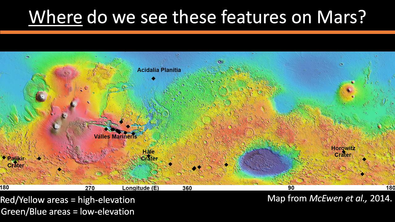
Locations of RSL features on Mars

NASA’s overriding agency wide goal is to send humans on a ‘Journey to Mars’ in the 2030s.

So NASA astronaut Mark Kelly exclaimed that he was also super excited about the findings, from his perch serving as Commander aboard the International Space Station (ISS), where he is a member of the first ever “1 Year ISS Mission Crew” aimed at learning how the human body will adapt to the long term missions required to send astronauts to Mars and back.

“One reason why NASA’s discovery of liquid water on #Mars is so exciting: we know anywhere there’s water on Earth, there’s some form of life,” Kelly tweeted today from on board the ISS, upon hearing today’s news.

The discovery of liquid water on Mars could also be a boon to future astronauts who could use it as a natural resource to ‘live off the land’ for sustenance and to make rocket fuel.

“If going to Mars on my Year In Space, I’d arrive soon to find water! H20 > rocket fuel, which means I could find my way back home too!,” Kelly wrote on his Facebook page.

“When most people talk about water on Mars, they’re usually talking about ancient water or frozen water,” Ojha explained.

“Now we know there’s more to the story. This is the first spectral detection that unambiguously supports our liquid water-formation hypotheses for RSL.”

Stay tuned here for Ken’s continuing Earth and planetary science and human spaceflight news.

Ken Kremer

Curiosity Snaps Stunning One of a Kind Belly Selfie At Buckskin Mountain Base Drill Site

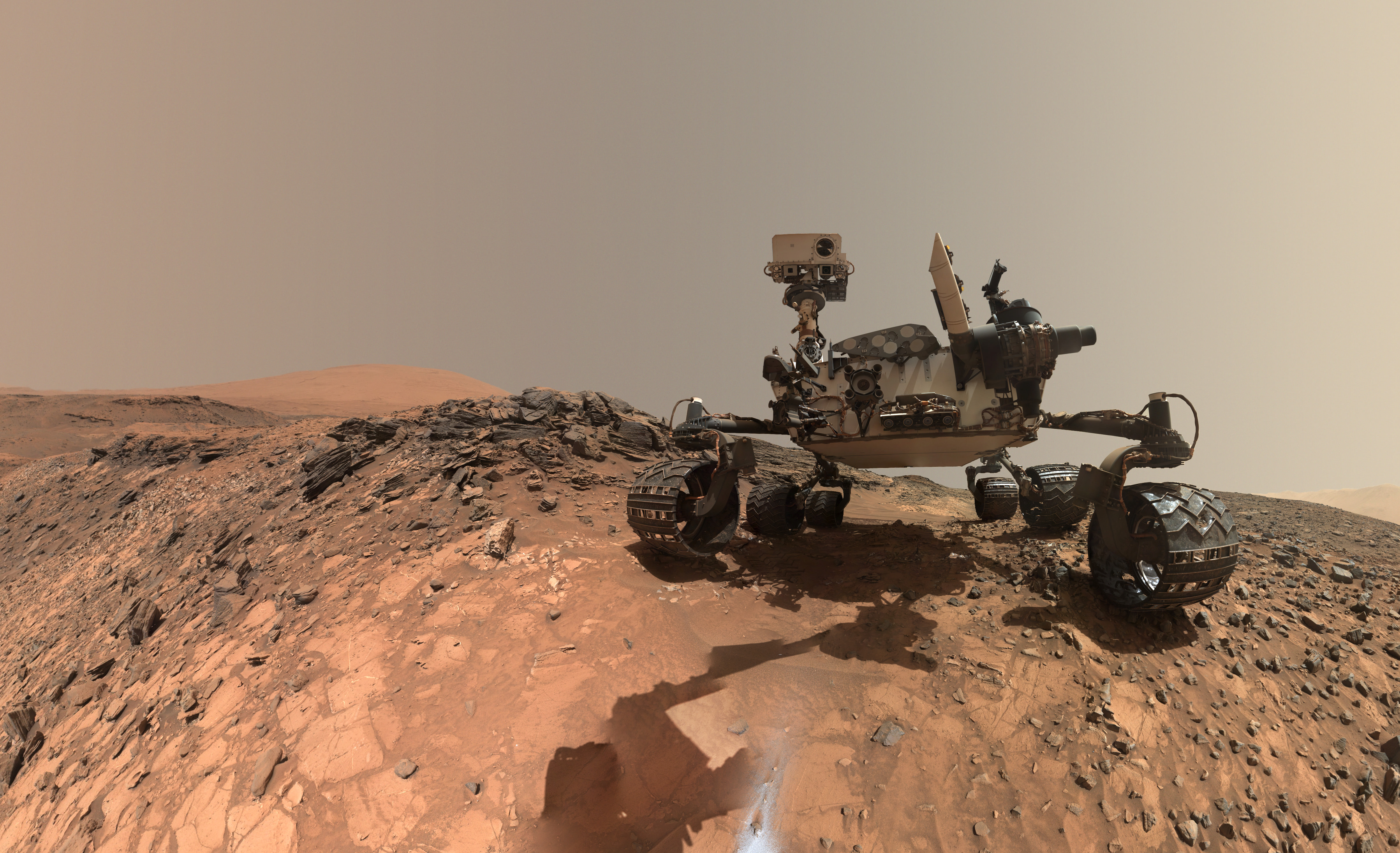
This low-angle self-portrait of NASA's Curiosity Mars rover shows the vehicle at the site from which it reached down to drill into a rock target called "Buckskin." The MAHLI camera on Curiosity's robotic arm took multiple images on Aug. 5, 2015, that were stitched together into this selfie. Credits: NASA/JPL-Caltech/MSSS

This low-angle self-portrait of NASA’s Curiosity Mars rover shows the vehicle at the site from which it reached down to drill into a rock target called “Buckskin.” The MAHLI camera on Curiosity’s robotic arm took multiple images on Aug. 5, 2015, that were stitched together into this selfie. Credits: NASA/JPL-Caltech/MSSS
More selfie and drilling mosaics below[/caption]

NASA’s Curiosity rover has snapped a stunningly beautiful, one of a kind ‘belly selfie’ amidst the painstaking ‘Buckskin’ drill campaign at the Martian mountain base marking the third anniversary since her touchdown on the Red Planet.

The unique self portrait was taken from a low-angle for the first time and shows the six wheeled rover at work collecting her seventh drilled sample at the ‘Buckskin’ rock target earlier this month in the “Marias Pass” area of lower Mount Sharp.

‘Buckskin’ is also unique in a fabulously scientifically way because the rover discovered a new type of Martian rock that’s surprisingly rich in silica – and unlike any other targets found before.

The low camera angle is what enables the awesome Buckskin belly selfie. It’s a distinctively dramatic view and actually stitched from 92 images captured by the Mars Hand Lens Imager (MAHLI) on Aug. 5, 2015, or Sol 1065 of the mission.

The high resolution MAHLI color camera is located on the end of the 7 foot-long (2.1 meter-long) robotic arm.

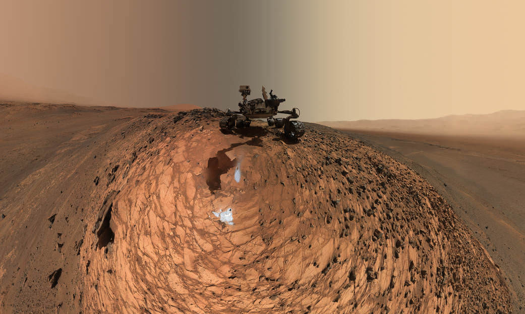
This version of a self-portrait of NASA's Curiosity Mars rover at a drilling site called "Buckskin" is presented as a stereographic projection, which shows the horizon as a circle. The MAHLI camera on Curiosity's robotic arm took dozens of component images for this selfie on Aug. 5, 2015.  Credits: NASA/JPL-Caltech/MSSS
This version of a self-portrait of NASA’s Curiosity Mars rover at a drilling site called “Buckskin” is presented as a stereographic projection, which shows the horizon as a circle. The MAHLI camera on Curiosity’s robotic arm took dozens of component images for this selfie on Aug. 5, 2015. Credits: NASA/JPL-Caltech/MSSS

Indeed the car-sized rover has taken spectacular selfies several times before during her three year long trek across the Martian surface, since the August 2012 landing inside Mars’ Gale Crater. But for those past selfies the MAHLI camera was hoisted higher to give the perspective of looking somewhat downward and showing the rovers top deck and trio of sample inlet ports.

In this case, the rover team specifically commanded Curiosity to position “the camera lower in relation to the rover body than for any previous full self-portrait of Curiosity,” said NASA officials.

Two patches of gray colored powdered rock material drilled from Buckskin are visible in the selfie scene, in front of the rover.

“The patch closer to the rover is where the sample-handling mechanism on Curiosity’s robotic arm dumped collected material that did not pass through a sieve in the mechanism. Sieved sample material was delivered to laboratory instruments inside the rover. The patch farther in front of the rover, roughly triangular in shape, shows where fresh tailings spread downhill from the drilling process.”

Prior selfies were taken at the “Rocknest” (http://photojournal.jpl.nasa.gov/catalog/PIA16468), “John Klein” (http://photojournal.jpl.nasa.gov/catalog/PIA16937), “Windjana” (http://photojournal.jpl.nasa.gov/catalog/PIA18390) and “Mojave” drill sites.

Basically in the Sol 1065 belly selfie at “Buckskin” we see the underbelly of the rover and all six wheels along with a complete self portrait.

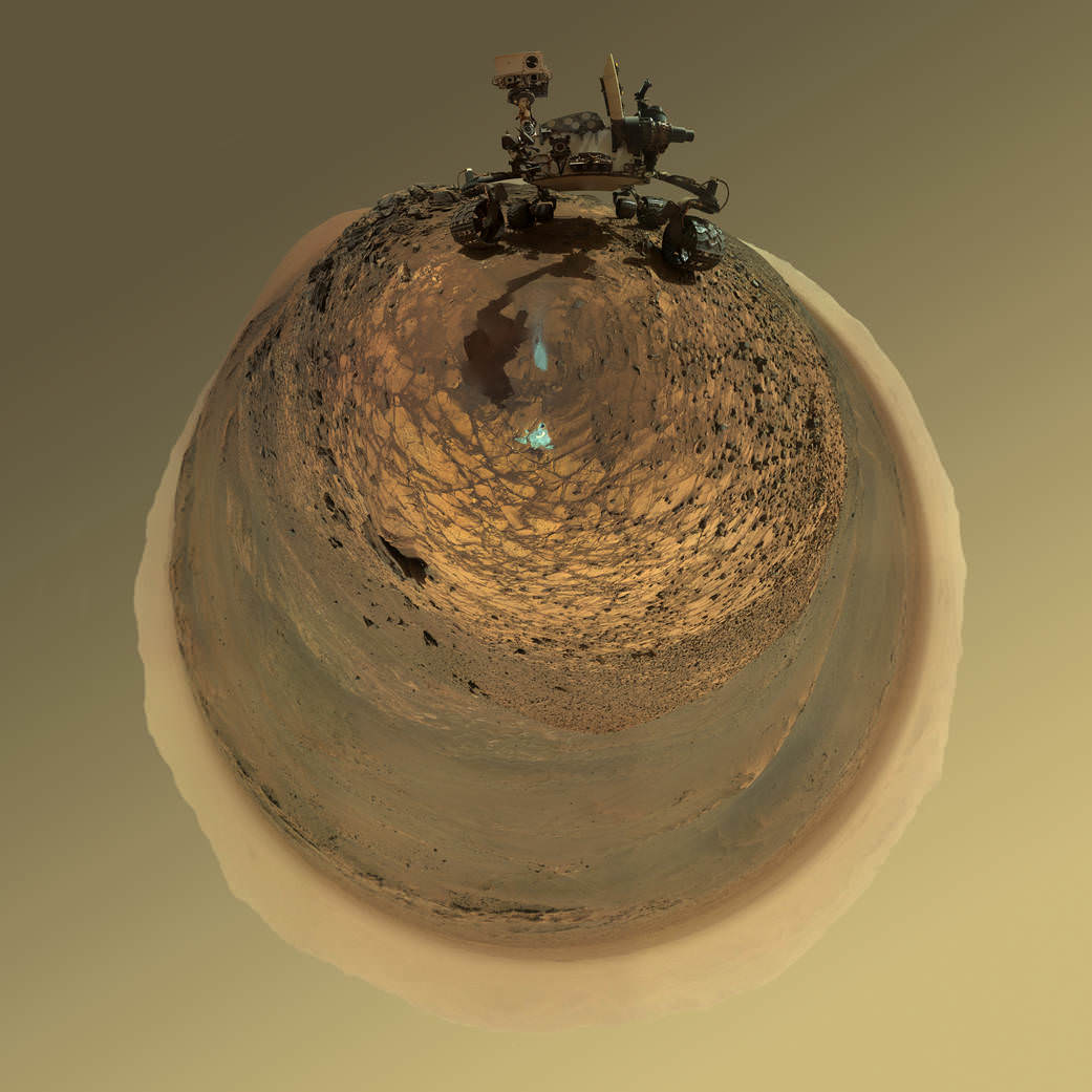
This version of a self-portrait of NASA's Curiosity Mars rover at a drilling site called "Buckskin" is presented as a stereographic projection, which shows the horizon as a circle. The MAHLI camera on Curiosity's robotic arm took dozens of component images for this selfie on Aug. 5, 2015.  Credits: NASA/JPL-Caltech/MSSS
This version of a self-portrait of NASA’s Curiosity Mars rover at a drilling site called “Buckskin” is presented as a stereographic projection, which shows the horizon as a circle. The MAHLI camera on Curiosity’s robotic arm took dozens of component images for this selfie on Aug. 5, 2015. Credits: NASA/JPL-Caltech/MSSS

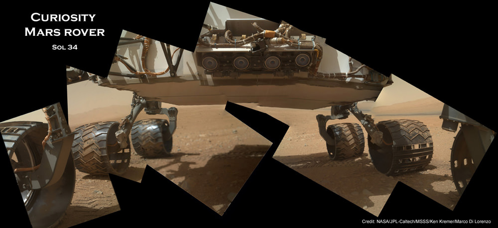
On several prior occasions, MAHLI was used to image just the underbelly and wheels to aid in inspecting the wheels to look for signs of damage inflicted by sharp-edged Martian rocks poking holes in the aluminum wheels.

Underbelly view of Curiosity rover and wheels on Sol 34.  Credit: NASA/JPL/MSSS/Ken Kremer/Marco Di Lorenzo
Underbelly view of Curiosity rover and wheels on Sol 34, Sept. 9, 2012. Credit: NASA/JPL/MSSS/Ken Kremer/Marco Di Lorenzo

Each wheel measures 20 inches (50 centimeters) in diameter and about 16 inches (40 centimeters) wide. And the MAHLI monitoring images have shown the effects of increasing wear and tear that ultimately forced the rover drivers to alter Curiosity’s driving route on the crater floor in favor of smoother and less rocky terrain imparting less damage to the critical wheels.

If you take a close look at the new selfie up top, you’ll see a small rock stuck onto Curiosity’s left middle wheel (on the right in this head-on view). The rock was seen also in prior wheel monitoring images taken three weeks ago.

“The selfie at Buckskin does not include the rover’s robotic arm beyond a portion of the upper arm held nearly vertical from the shoulder joint. With the wrist motions and turret rotations used in pointing the camera for the component images, the arm was positioned out of the shot in the frames or portions of frames used in this mosaic,” according to officials.

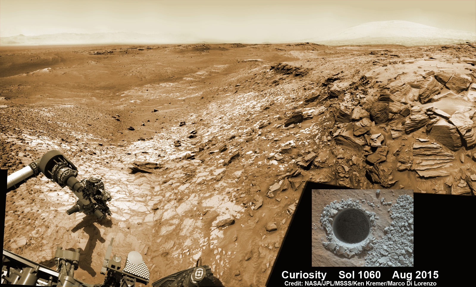
The drilling campaign into “Buckskin” was successfully conducted on Sol 1060 (July 30, 2015) at the bright toned “Lion” outcrop to a full depth of about 2.6 inches (6.5 centimeters) and approximately 1.6 cm (0.63 inch) diameter.

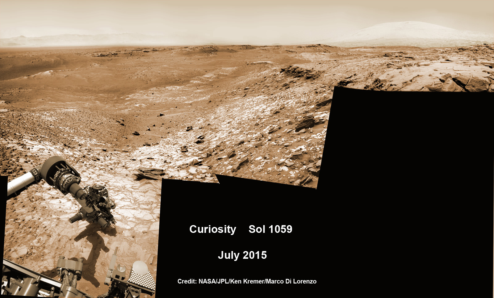
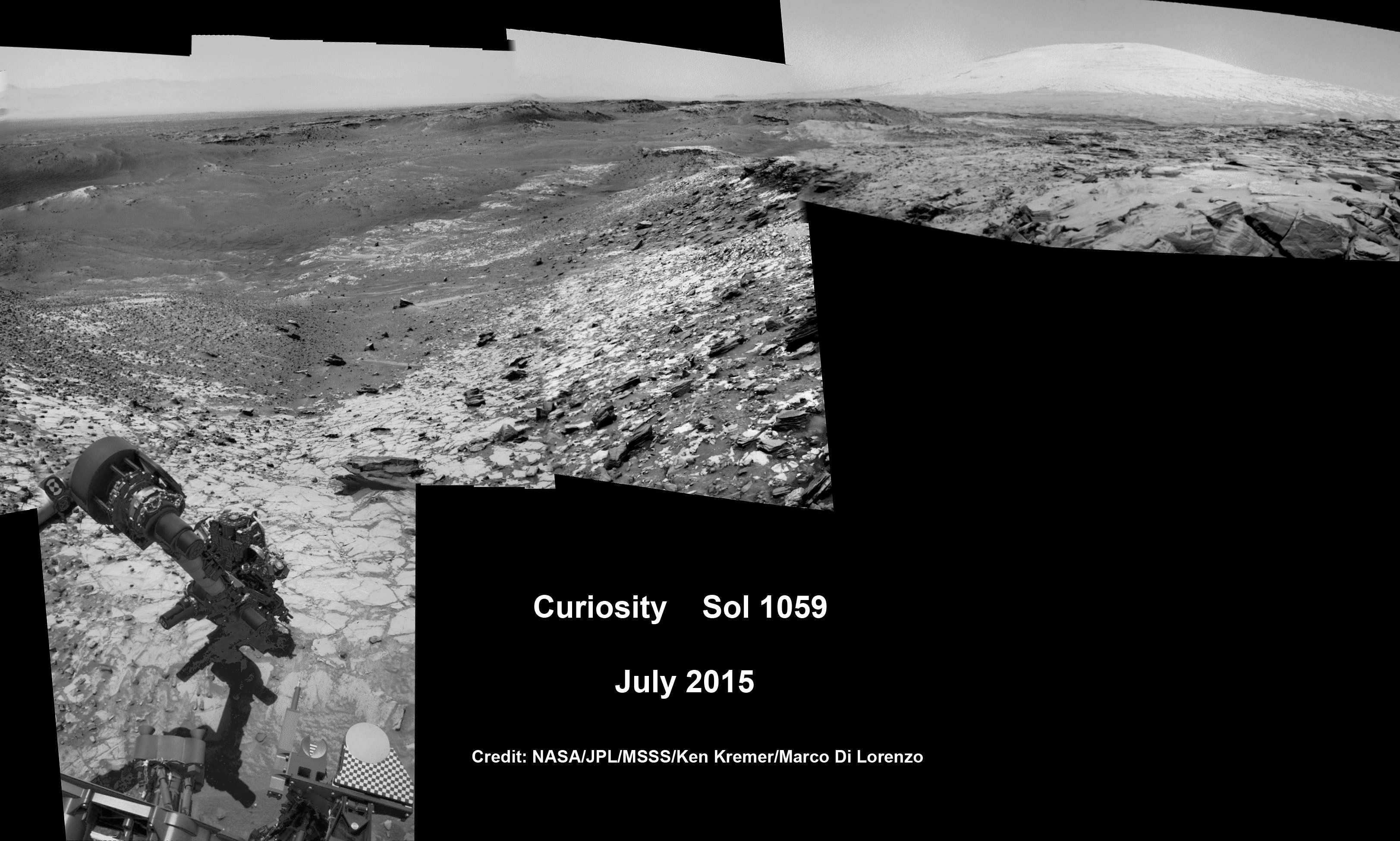
Curiosity extends robotic arm and conducts sample drilling at “Buckskin” rock target at bright toned “Lion” outcrop at the base of Mount Sharp on Mars, seen at right.   Gale Crater eroded rim seen in the distant background at left, in this composite multisol mosaic of navcam raw images taken to Sol 1059, July 30, 2015.  Navcam camera raw images stitched and colorized. Inset: MAHLI color camera up close image of full depth drill hole at “Buckskin” rock target on Sol 1060.  Credit:  NASA/JPL-Caltech/MSSS/Ken Kremer/kenkremer.com/Marco Di Lorenzo
Curiosity extends robotic arm and conducts sample drilling at “Buckskin” rock target at bright toned “Lion” outcrop at the base of Mount Sharp on Mars, seen at right. Gale Crater eroded rim seen in the distant background at left, in this composite multisol mosaic of navcam raw images taken to Sol 1059, July 30, 2015. Navcam camera raw images stitched and colorized. Inset: MAHLI color camera up close image of full depth drill hole at “Buckskin” rock target on Sol 1060. Credit: NASA/JPL-Caltech/MSSS/Ken Kremer/kenkremer.com/Marco Di Lorenzo

You can also see another perspective of the rover at work while reaching out with the robotic arm and drilling into ‘Buckskin’ as illustrated in our mosaics of mastcam and navcam camera raw images created by the image processing team of Ken Kremer and Marco Di Lorenzo.

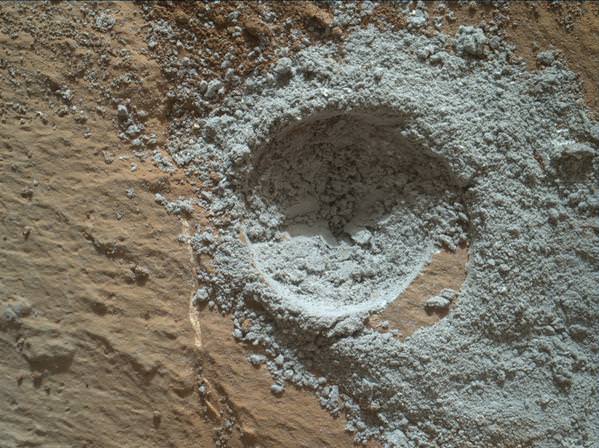
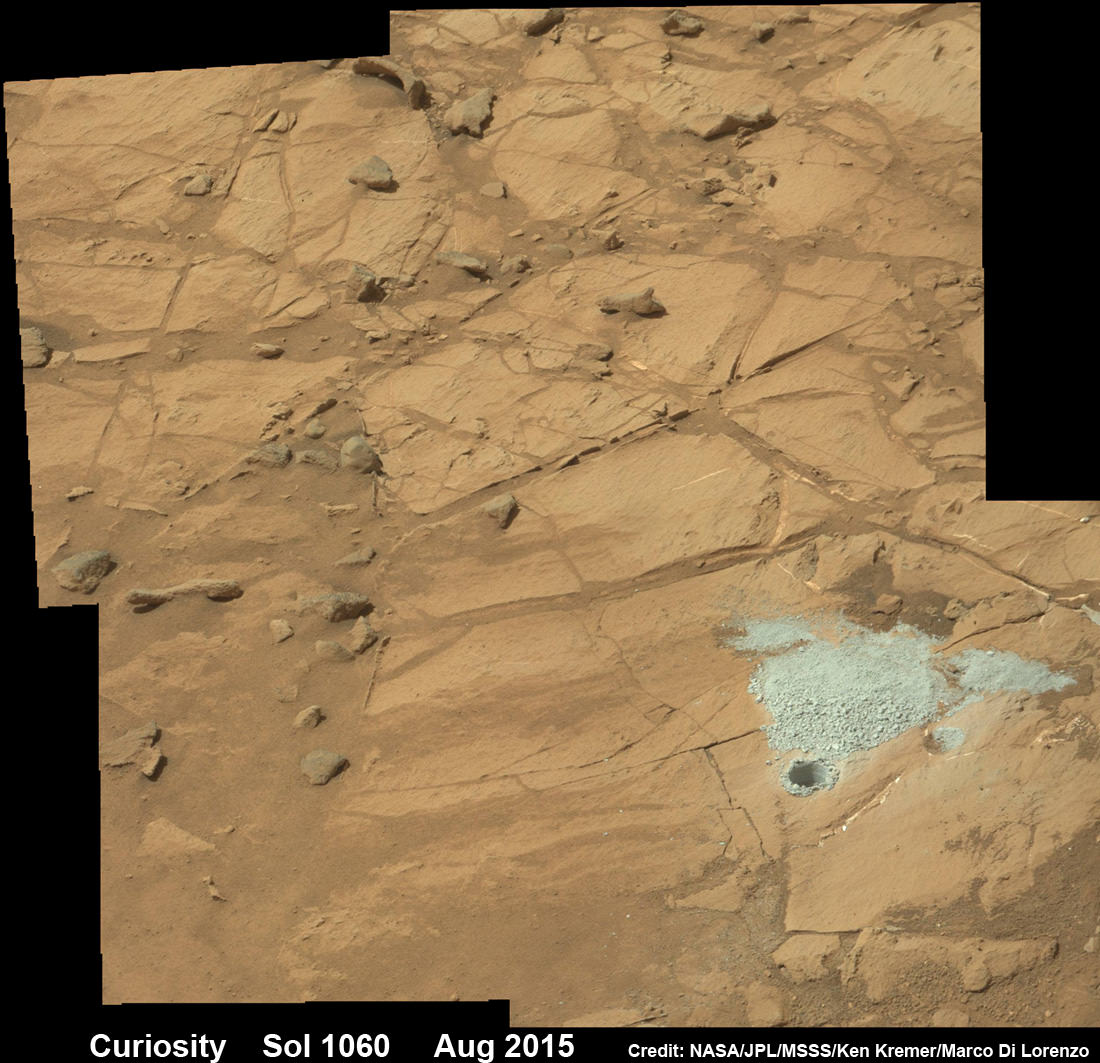
The main bore hole was drilled next to the initial mini hole test and shows the indicative residue of grey colored tailings from the Martian subsurface seen distributed around the new hole.

Curiosity rover successfully drills into Martian outcrop  at Buckskin rock target at current work site at base of Mount Sharp in August 2015, in this mosaic showing full depth drill hole and initial test hole, with grey colored subsurface tailings and mineral veins on surrounding Red Planet terrain.  This high resolution photo mosaic is a multisol composite of color images taken by the mast mounted Mastcam-100 color camera up to Sol 1060, July 31, 2015.   Credit:  NASA/JPL-Caltech/Ken Kremer/kenkremer.com/Marco Di Lorenzo
Curiosity rover successfully drills into Martian outcrop at Buckskin rock target at current work site at base of Mount Sharp in August 2015, in this mosaic showing full depth drill hole and initial test hole, with grey colored subsurface tailings and mineral veins on surrounding Red Planet terrain. This high resolution photo mosaic is a multisol composite of color images taken by the mast mounted Mastcam-100 color camera up to Sol 1060, July 31, 2015. Credit: NASA/JPL-Caltech/Ken Kremer/kenkremer.com/Marco Di Lorenzo

Curiosity has now moved on from the “Marias Pass” area.

Curiosity recently celebrated 1000 Sols of exploration on Mars on May 31, 2015 – detailed here with our Sol 1000 mosaic also featured at Astronomy Picture of the Day on June 13, 2015.

As of today, Sol 1080, August 20, 2015, she has driven some 6.9 miles (11.1 kilometers) kilometers and taken over 260,000 amazing images.

Curiosity rover scans toward south east around Marias Pass area at the base of Mount Sharp on Mars on Sol 1074, Aug. 14, 2015 in this photo mosaic stitched from Mastcam color camera raw images.  Credit: NASA/JPL/MSSS/Marco Di Lorenzo/Ken Kremer/kenkremer.com
Curiosity rover scans toward south east around Marias Pass area at the base of Mount Sharp on Mars on Sol 1074, Aug. 14, 2015 in this photo mosaic stitched from Mastcam color camera raw images. Credit: NASA/JPL/MSSS/Marco Di Lorenzo/Ken Kremer/kenkremer.com

Curiosity has already accomplished her primary objective of discovering a habitable zone on the Red Planet – at the Yellowknife Bay area – that contains the minerals necessary to support microbial life in the ancient past when Mars was far wetter and warmer billions of years ago.

Stay tuned here for Ken’s continuing Earth and planetary science and human spaceflight news.
Ken Kremer

Curiosity Discovers Mars Rock Like None Before, Sets Drill Campaign

Curiosity extends robotic arm and conducts test drill at “Buckskin” rock target at bright toned “Lion” outcrop on the lower region of Mount Sharp on Mars, seen at right. Gale Crater eroded rim seen in the distant background at left, in this composite multisol mosaic of navcam raw images taken to Sol 1059, July 30, 2015. Navcam camera raw images stitched and colorized. Credit: NASA/JPL-Caltech/Ken Kremer/kenkremer.com/Marco Di Lorenzo

On the eve of the 3rd anniversary since her nail biting touchdown inside Gale Crater, NASA’s car sized Curiosity Mars Science Laboratory (MSL) rover has discovered a new type of Martian rock that’s surprisingly rich in silica – and unlike any other targets found before.

Excited by this new science finding on Mars, Curiosity’s handlers are now gearing the robot up for her next full drill campaign today, July 31 (Sol 1060) into a rock target called “Buckskin” – which lies at the base of Mount Sharp, the huge layered mountain that is the primary science target of this Mars rover mission.

“The team selected the “Buckskin” target to drill,” says Lauren Edgar, Research Geologist at the USGS Astrogeology Science Center and an MSL science team member, in a mission update.

“It’s another exciting day on Mars!”

See the rover at work reaching out with her robotic arm and drilling into Buckskin, as illustrated in our new mosaics of navcam camera images created by the image processing team of Ken Kremer and Marco Di Lorenzo (above and below). Also featured at Alive Universe Images – here.

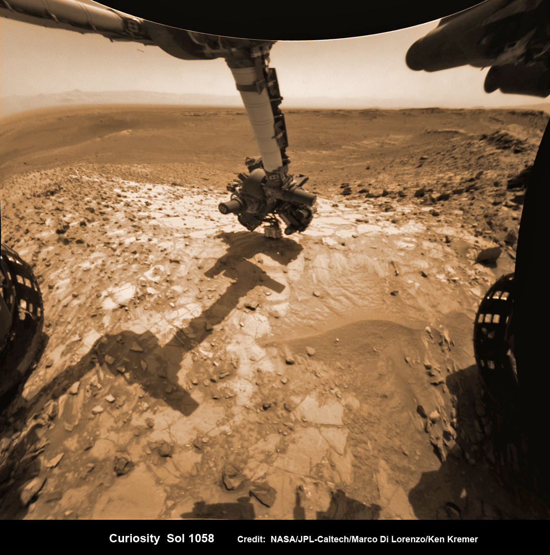
NASA Curiosity rover inspects ‘Buckskin’ rock outcrop on Mars with APXS mineral spectrometer in this hazcam camera raw image taken on July 29, 2015 (Sol 1058), colorized and linearized.  Credit:  NASA/JPL-Caltech/Marco Di Lorenzo/Ken Kremer/kenkremer.com
NASA Curiosity rover inspects ‘Buckskin’ rock outcrop on Mars with APXS mineral spectrometer in this hazcam camera raw image taken on July 29, 2015 (Sol 1058), colorized and linearized. Credit: NASA/JPL-Caltech/Marco Di Lorenzo/Ken Kremer/kenkremer.com

For about the past two months, the six wheeled robot has been driving around and exploring a geological contact zone named “Marias Pass” – an area on lower Mount Sharp, by examining the rocks and outcrops with her suite of state-of-the-art science instruments.

The goal is to provide geologic context for her long term expedition up the mountains sedimentary layers to study the habitability of the Red Planet over eons of time.

Data from Curiosity’s “laser-firing Chemistry & Camera (ChemCam) and Dynamic Albedo of Neutrons (DAN), show elevated amounts of silicon and hydrogen, respectively,” in certain local area rocks, according to the team.

Silica is a rock-forming compound containing silicon and oxygen, commonly found on Earth as quartz.

“High levels of silica could indicate ideal conditions for preserving ancient organic material, if present, so the science team wants to take a closer look.”

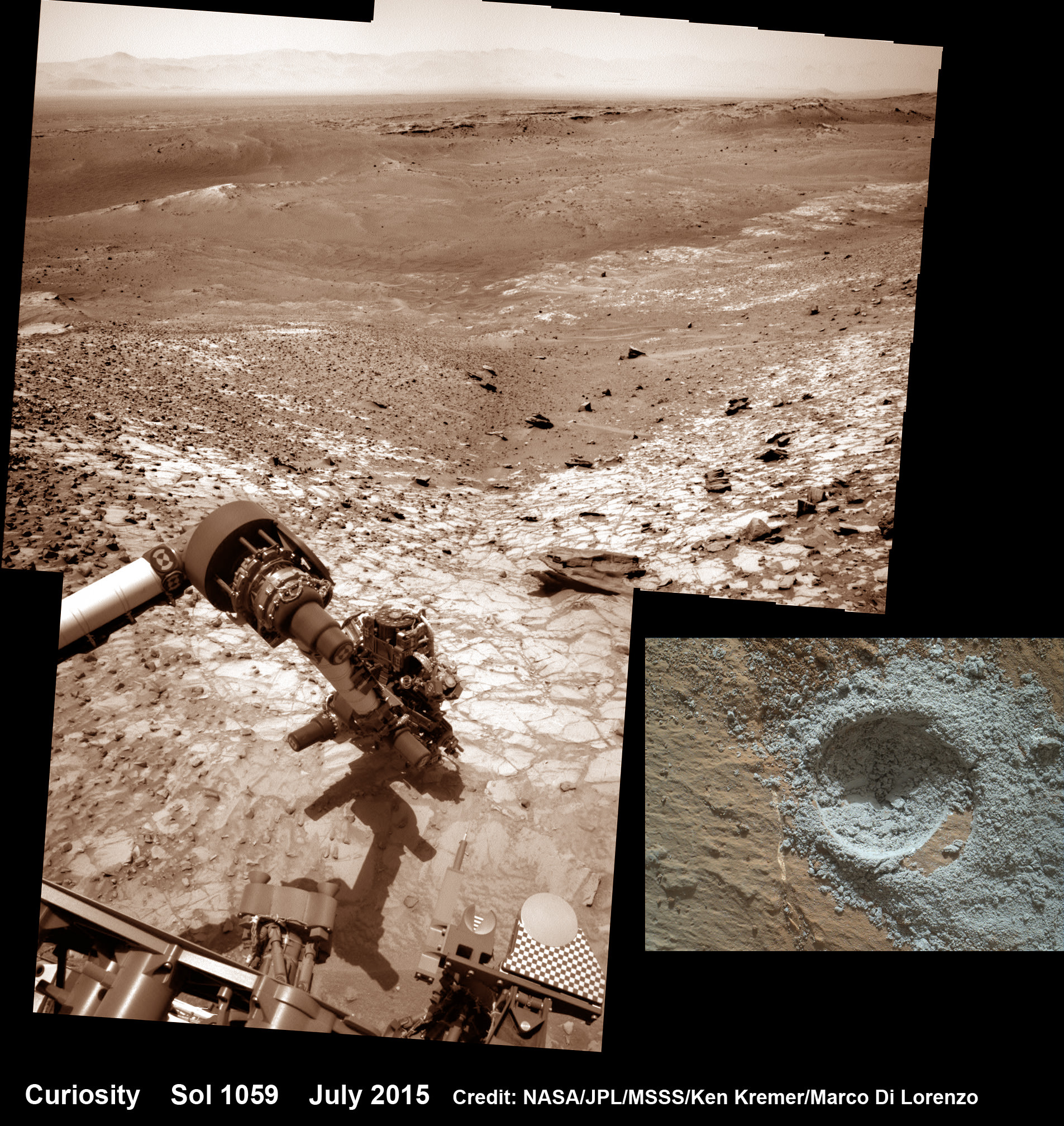
Curiosity conducts test drill at “Buckskin” rock target at bright toned “Lion” outcrop on the lower region of Mount Sharp on Mars.   Gale crater rim seen in the distant background, in this composite mosaic of navcam raw images taken to Sol 1059, July 30, 2015.  Navcam camera raw images stitched and colorized. Credit:  NASA/JPL-Caltech/Ken Kremer/kenkremer.com/Marco Di Lorenzo  Inset: MAHLI camera up close image of  test drill at “Buckskin” rock target.  Credit: NASA/JPL-Caltech/MSSS
Curiosity extends robotic arm and conducts test drill at “Buckskin” rock target at bright toned “Lion” outcrop on the lower region of Mount Sharp on Mars. Gale crater rim seen in the distant background, in this composite mosaic of navcam raw images taken to Sol 1059, July 30, 2015. Inset: MAHLI camera up close image of test drill at “Buckskin” rock target. Navcam camera raw images stitched and colorized. Credit: NASA/JPL-Caltech/Ken Kremer/kenkremer.com/Marco Di Lorenzo Credit: NASA/JPL-Caltech/MSSS

Therefore the team scouted targets suitable for in depth analysis and sample drilling and chose “Buckskin”.

“Buckskin” is located among some high-silica and hydrogen enriched targets at a bright outcrop named “Lion.”

An initial test bore operation was conducted first to confirm whether that it was indeed safe to drill into “Buckskin” and cause no harm to the rover before committing to the entire operation.

The bore hole is about 1.6 cm (0.63 inch) in diameter.

“This test will drill a small hole in the rock to help determine whether it is safe to go ahead with the full hole,” elaborated Ryan Anderson, planetary scientist at the USGS Astrogeology Science Center and an MSL science team member.

So it was only after the team received back new high resolution imagery last night from the arm-mounted MAHLI camera which confirmed the success of the mini-drill operation, that the “GO” was given for a full depth drill campaign. MAHLI is short for Mars Hand Lens Imager.

“We successfully completed a mini drilling test yesterday (shown in the MAHLI image). That means that today we’re going for the FULL drill hole” Edgar confirmed.

“GO for Drilling.”

So it’s a busy day ahead on the Red Planet, including lots of imaging along the way to document and confirm that the drilling operation proceeds safely and as planned.

“First we’ll acquire MAHLI images of the intended drill site, then we’ll drill, and then we’ll acquire more MAHLI images after drilling,” Edgar explains.

“The plan also includes Navcam imaging of the workspace, and Mastcam imaging of the target and drill bit. In addition to drilling, we’re getting CheMin ready to receive sample in an upcoming plan. Fingers crossed!” Surface observations with the arm-mounted Alpha Particle X-ray Spectrometer (APXS) instrument are also planned.

If all goes well, the robot will process and pulverize the samples for eventual delivery to the onboard pair of miniaturized chemistry labs located inside her belly – SAM and CheMin. Tiny samples will be fed to the inlet ports on the rover deck through the sieved filters.

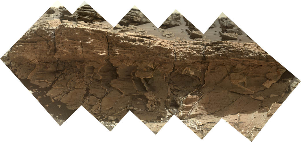
A rock outcrop dubbed "Missoula," near Marias Pass on Mars, is seen in this image mosaic taken by the Mars Hand Lens Imager on NASA's Curiosity rover. Pale mudstone (bottom of outcrop) meets coarser sandstone (top) in this geological contact zone, which has piqued the interest of Mars scientists.   Credit: NASA/JPL-Caltech/MSSS
A rock outcrop dubbed “Missoula,” near Marias Pass on Mars, is seen in this image mosaic taken by the Mars Hand Lens Imager on NASA’s Curiosity rover. Pale mudstone (bottom of outcrop) meets coarser sandstone (top) in this geological contact zone, which has piqued the interest of Mars scientists. Credit: NASA/JPL-Caltech/MSSS

Meanwhile the team is studying a nearby rock outcrop called “Ch-paa-qn” which means “shining peak” in the native Salish language of northern Montana.”

Anderson says the target is a bright patch on a nearby outcrop. Via active and passive observations with the mast-mounted ChemCam laser and Mastcam multispectral imager, the purpose is to determine if “Ch-paa-qn” is comprised of calcium sulfate like other white veins visible nearby, or perhaps it’s something else entirely.

A rock fragment dubbed "Lamoose" is shown in this picture taken by the Mars Hand Lens Imager (MAHLI) on NASA's Curiosity rover. Like other nearby rocks in a portion of the "Marias Pass" area of Mt. Sharp, Mars, it has unusually high concentrations of silica. The high silica was first detected in the area by the Chemistry & Camera (ChemCam) laser spectrometer. This rock was targeted for follow-up study by the MAHLI and the arm-mounted Alpha Particle X-ray Spectrometer (APXS).  Credits: NASA/JPL-Caltech/MSSS
A rock fragment dubbed “Lamoose” is shown in this picture taken by the Mars Hand Lens Imager (MAHLI) on NASA’s Curiosity rover. Like other nearby rocks in a portion of the “Marias Pass” area of Mt. Sharp, Mars, it has unusually high concentrations of silica. The high silica was first detected in the area by the Chemistry & Camera (ChemCam) laser spectrometer. This rock was targeted for follow-up study by the MAHLI and the arm-mounted Alpha Particle X-ray Spectrometer (APXS). Credits: NASA/JPL-Caltech/MSSS

Before arriving by the “Lion” outcrop last week, Curiosity was investigating another outcrop area nearby, the high-silica target dubbed “Elk” with the ChemCam instrument, while scouting around the “Marias Pass” area in search of tasty science targets for in-depth analysis.

Sometimes the data subsequently returned and analyzed is so extraordinary, that the team decides on a return trip to a spot previously departed. Such was the case with “Elk” and the rover was commanded to do a U-turn to acquire more precious data.

“One never knows what to expect on Mars, but the Elk target was interesting enough to go back and investigate,” said Roger Wiens, the principal investigator of the ChemCam instrument from the Los Alamos National Laboratory in New Mexico.

Soon, ChemCam will have fired on its 1,000th target. Overall the laser blaster has been fired more than 260,000 times since Curiosity landed inside the nearly 100 mile wide Gale Crater on Mars on Aug. 6, 2012, alongside Mount Sharp.

“ChemCam acts like eyes and ears of the rover for nearby objects,” said Wiens.

“Marias Pass” is a geological context zone where two rock types overlap – pale mudstone meets darker sandstone.

The rover spotted a very curious outcrop named “Missoula.”

“We found an outcrop named Missoula where the two rock types came together, but it was quite small and close to the ground. We used the robotic arm to capture a dog’s-eye view with the MAHLI camera, getting our nose right in there,” said Ashwin Vasavada, the mission’s project scientist at NASA’s Jet Propulsion Laboratory in Pasadena, California.

White mineral veins, possibly comprised of calcium sulfate, filled the fractures by depositing the mineral from running groundwater.

“Such clues help scientists understand the possible timing of geological events,” says the team.

Read more about Curiosity in an Italian language version of this story at Alive Universe Images – here.

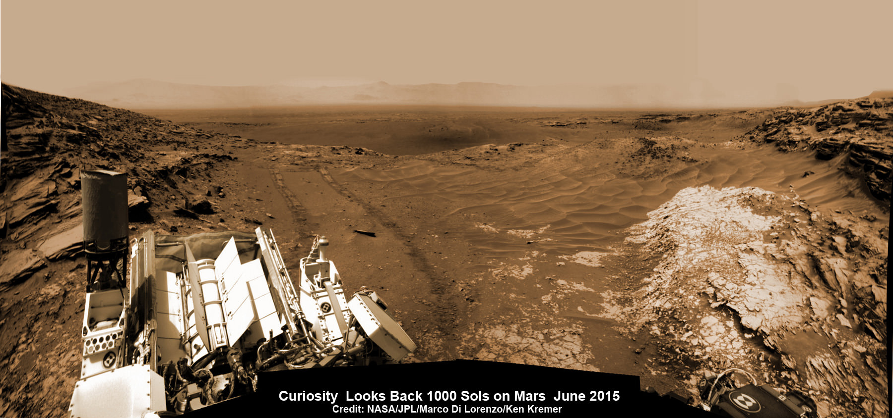
NASA’s Martian Curiosity rover looks backs to 1000 Sols of science and exploration on the surface of the Red Planet.  Robot wheel tracks lead back through valley dunes.  Gale Crater rim seen in the distant hazy background.  Sol 997 (May 28, 2015) navcam camera raw images stitched and colorized. Credit:  NASA/JPL-Caltech/ Marco Di Lorenzo/Ken Kremer/kenkremer.com
NASA’s Martian Curiosity rover looks backs to 1000 Sols of science and exploration on the surface of the Red Planet. Robot wheel tracks lead back through valley dunes. Gale Crater rim seen in the distant hazy background. Sol 997 (May 28, 2015) navcam camera raw images stitched and colorized. Credit: NASA/JPL-Caltech/ Marco Di Lorenzo/Ken Kremer/kenkremer.com
Featured on APOD on June 13, 2015

As of today, Sol 1060, July 31, 2015, she has taken over 255,000 amazing images.

Curiosity recently celebrated 1000 Sols of exploration on Mars on May 31, 2015 – detailed here with our Sol 1000 mosaic also featured at Astronomy Picture of the Day on June 13, 2015.

Stay tuned here for Ken’s continuing Earth and planetary science and human spaceflight news.
Ken Kremer

Red Mars, Gray Mars: "Mini-start hole" drill maneuver was successful.  Image of mini start drill hole taken by Mars Hand Lens Imager (MAHLI) aboard NASA's Mars rover Curiosity on July 30, 2015, Sol 1059. Credit: NASA/JPL-Caltech/MSSS
Red Mars, Gray Mars: “Mini-start hole” drill maneuver was successful. Image of mini start drill hole taken by Mars Hand Lens Imager (MAHLI) aboard NASA’s Mars rover Curiosity on July 30, 2015, Sol 1059. Credit: NASA/JPL-Caltech/MSSS
Curiosity conducts test drill at “Buckskin” rock target at bright toned “Lion” outcrop on the lower region of Mount Sharp on Mars, seen at right.   Gale crater rim seen in the distant background at left, in this composite mosaic of navcam raw images taken to Sol 1059, July 30, 2015.  Navcam camera raw images stitched. Credit:  NASA/JPL-Caltech/Ken Kremer/kenkremer.com/Marco Di Lorenzo
Curiosity extends robotic arm and conducts test drill at “Buckskin” rock target at bright toned “Lion” outcrop on the lower region of Mount Sharp on Mars, seen at right. Gale crater rim seen in the distant background at left, in this composite mosaic of navcam raw images taken to Sol 1059, July 30, 2015. Navcam camera raw images stitched. Credit: NASA/JPL-Caltech/Ken Kremer/kenkremer.com/Marco Di Lorenzo

NASA Gives ‘GO’ for Mission to Alien Ocean World at Jupiter Moon Europa

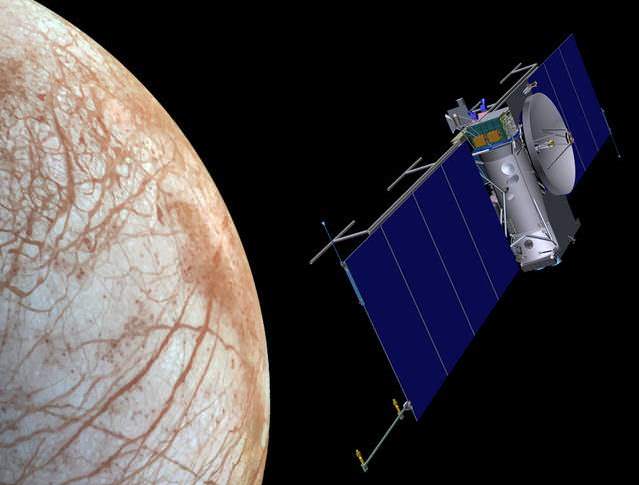
Artist's concept of NASA mission streaking over Europa. Credit: NASA/JPL

Artist’s concept of NASA mission streaking over ocean world of Europa. Credit: NASA/JPL
Story updated[/caption]

At long last NASA is heading back to Jupiter’s mysterious moon Europa and doing so in a big way – because scientists believe it harbors an alien ocean of water beneath an icy crust and therefore is “one of the most promising places in the solar system to search for signs of present-day life” beyond Earth.

Top NASA officials have now formally and officially green lighted the Europa ocean world robotic mission and given it the “GO” to move from early conceptual studies into development of the interplanetary spacecraft and mission hardware, to search for the chemical constituents of life.

“Today we’re taking an exciting step from concept to mission, in our quest to find signs of life beyond Earth,” said John Grunsfeld, associate administrator for NASA’s Science Mission Directorate in Washington, in a NASA statement.

The goal is to investigate the habitability of Europa’s subsurface ocean, determine if it possesses the ingredients for life and advance our understanding of “Are we Alone?”

“Observations of Europa have provided us with tantalizing clues over the last two decades, and the time has come to seek answers to one of humanity’s most profound questions,” said Grunsfeld.

Water is a prerequisite for life as we know it.

“We know that on Earth everywhere there is water we find life,” says Robert Pappalardo, Europa mission project scientist.

“Therefore Europa is the most likely place to find life in our solar system today because we think there is a liquid water ocean beneath its surface.”

Video caption: Alien Ocean: NASA’s Mission to Europa. Could a liquid water ocean beneath the surface of Jupiter’s moon Europa have the ingredients to support life? Here’s how NASA’s mission to Europa would find out. Credit: NASA

After a thorough review of the mission concept, managers agreed that it “successfully completed its first major review by the agency and now is entering the development phase known as formulation

“It’s a great day for science,” said Joan Salute, Europa program executive at NASA Headquarters in Washington.

“We are thrilled to pass the first major milestone in the lifecycle of a mission that will ultimately inform us on the habitability of Europa.”

In a major milestone leading up to this mission development approval, NASA managers recently announced the selection of the nine science instruments that will fly on the agency’s long awaited planetary science mission to this intriguing world that many scientists suspect could support life, as I reported here last month.

“We are trying to answer big questions. Are we alone,” said Grunsfeld at the May 26 media briefing.

“The young surface seems to be in contact with an undersea ocean.”

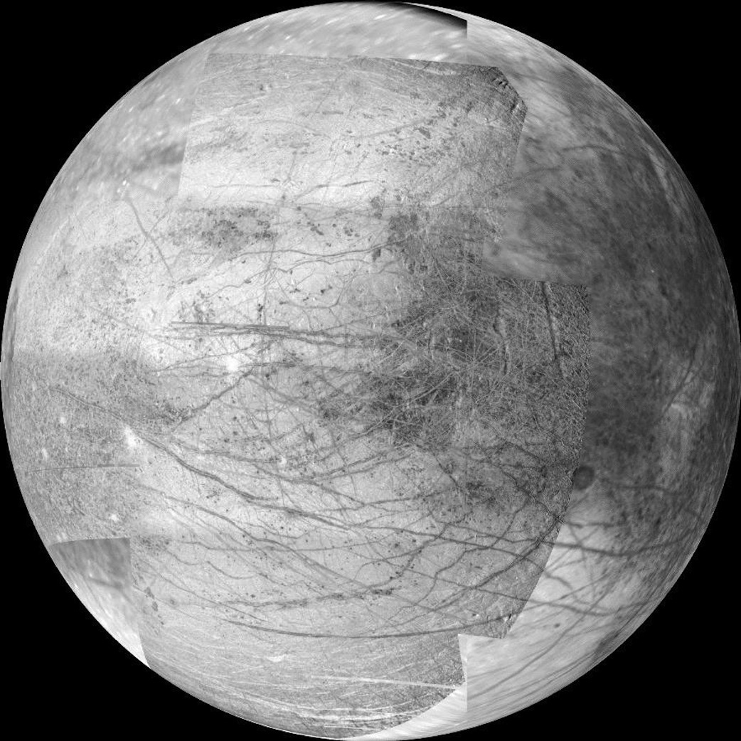
This 12-frame mosaic provides the highest resolution view ever obtained of the side of Jupiter's moon Europa that faces the giant planet. It was obtained on Nov. 25, 1999 by the camera onboard the Galileo spacecraft, a past NASA mission to Jupiter and its moons. Credit: NASA/JPL/University of Arizona
This 12-frame mosaic provides the highest resolution view ever obtained of the side of Jupiter’s moon Europa that faces the giant planet. It was obtained on Nov. 25, 1999 by the camera onboard the Galileo spacecraft, a past NASA mission to Jupiter and its moons. Credit: NASA/JPL/University of Arizona

Planetary scientists have long desired a speedy to return on Europa, ever since the groundbreaking discoveries of NASA’s Galileo Jupiter orbiter in the 1990s showed that the alien world possessed a substantial and deep subsurface ocean beneath an icy shell that appears to interact with and alter the moon’s surface in recent times.

NASA’s Europa mission would blastoff perhaps as soon as 2022, depending on the budget allocation and rocket selection – whose candidates include the heavy lift Space Launch System (SLS) now under development to launch astronauts on deep space expedition to the Moon, Asteroids and Mars.

The solar powered Europa probe will go into orbit around Jupiter for a three year mission in order to minimize exposure to the intense radiation region that could harm the spacecraft.

The Europa mission goal is to investigate whether the tantalizing icy Jovian moon, similar in size to Earth’s moon, could harbor conditions suitable for the evolution and sustainability of life in the suspected ocean.

It will be equipped with high resolution cameras, spectrometers and radar, several generations beyond anything before to map the surface in unprecedented detail and determine the moon’s composition and subsurface character. And it will search for subsurface lakes and seek to sample erupting vapor plumes like those occurring today on Saturn’s tiny moon Enceladus.

There will many opportunities for close flybys of Europa during the three year primary mission to conduct unprecedented studies of the composition and structure of the surface, icy shell and oceanic interior.

“During the three year mission, the orbiter will conduct 45 close flyby’s of Europa,” Curt Niebur, Europa program scientist at NASA Headquarters in Washington, told Universe Today.

“These will occur about every two to three weeks.”

The close flyby’s will vary in altitude from 16 miles to 1,700 miles (25 kilometers to 2,700 kilometers).

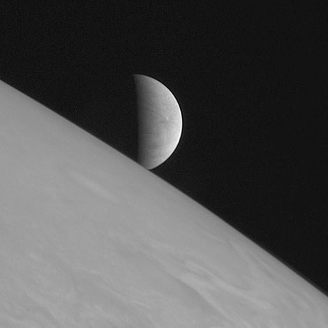
Europa rising. The icy moon hangs above Jupiter cloud tops in a @NASANewHorizons image from 2007.  Credit: NASA
Europa rising. The icy moon hangs above Jupiter cloud tops in a @NASANewHorizons image from 2007. Credit: NASA

The mission currently has a budget of about $10 million for 2015 and $30 Million in 2016. Over the next three years the mission concept will be further defined.

The mission will be managed by NASA’s Jet Propulsion Laboratory (JPL) in Pasadena, California and is expected to cost in the range of at least $2 Billion or more.

The nine science instruments are described in my earlier story- here. They will be developed and built by Johns Hopkins University Applied Physics Laboratory (APL); JPL; Arizona State University, Tempe; the University of Texas at Austin; Southwest Research Institute, San Antonio and the University of Colorado, Boulder.

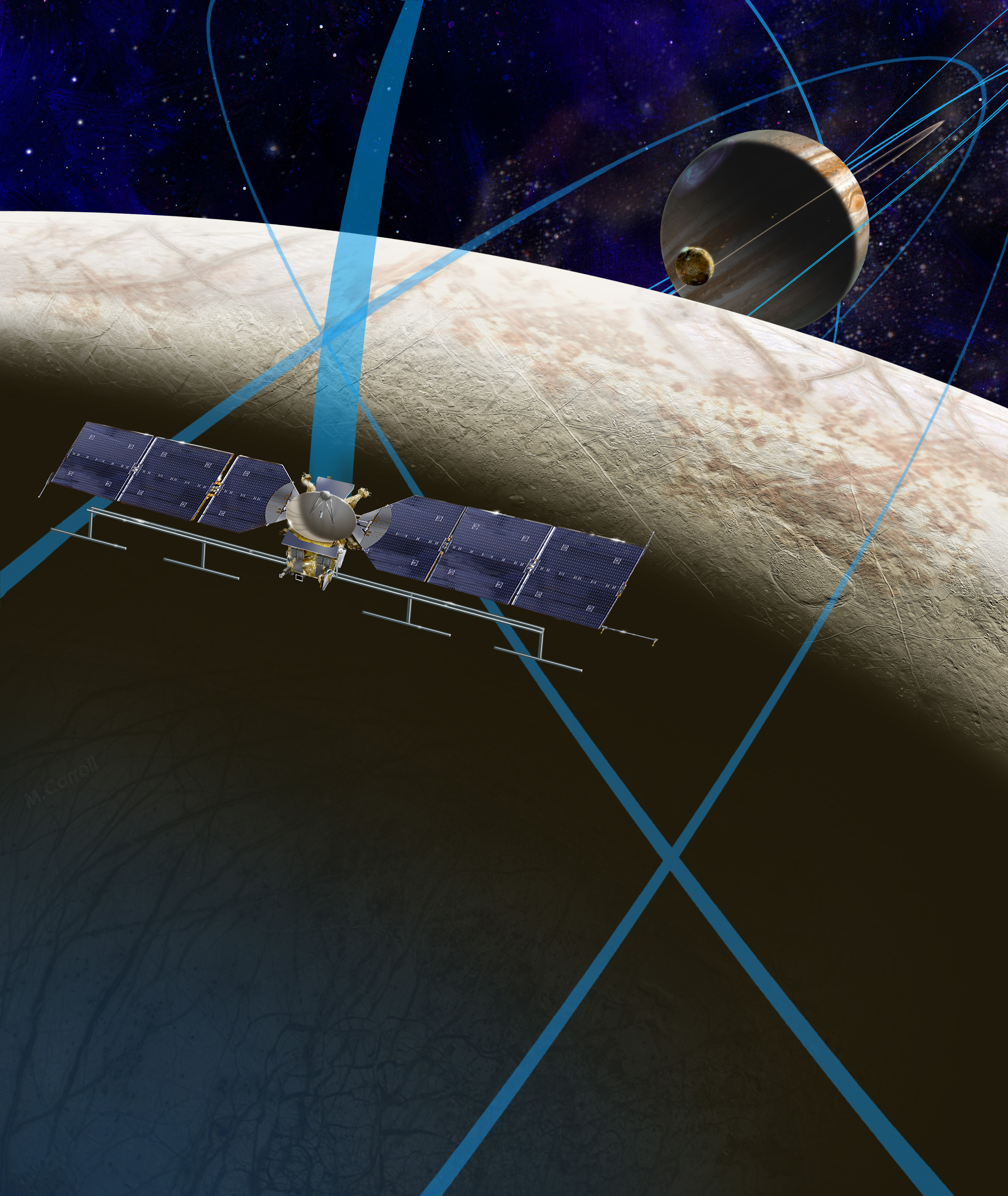
This artist's rendering shows a concept for a future NASA mission to Europa in which a spacecraft would make multiple close flybys of the icy Jovian moon, thought to contain a global subsurface ocean.  Credits: NASA/JPL-Caltech
This artist’s rendering shows a concept for a future NASA mission to Europa in which a spacecraft would make multiple close flybys of the icy Jovian moon, thought to contain a global subsurface ocean. Credits: NASA/JPL-Caltech

Right now there is another NASA probe bound for Jupiter, the solar powered Juno orbiter that will investigate the origin of the gas giant. But Juno will not be conducting any observations or flyby’s of Europa.

Stay tuned here for Ken’s continuing Earth and planetary science and human spaceflight news.
Ken Kremer

………….

Learn more about SpaceX, Europa, Mars rovers, Orion, SLS, Antares, NASA missions and more at Ken’s upcoming outreach events:

Jun 25-27: “SpaceX launch, Orion, Commercial crew, Curiosity explores Mars, MMS, Antares and more,” Kennedy Space Center Quality Inn, Titusville, FL, evenings

The Martian Curiosity Looks Back on 1000 Sols of Exploration on the Red Planet

NASA’s Martian Curiosity rover looks backs to 1000 Sols of science and exploration on the surface of the Red Planet. Robot wheel tracks lead back through valley dunes. Gale Crater rim seen in the distant hazy background. Sol 997 (May 28, 2015) navcam camera raw images stitched and colorized. Credit: NASA/JPL-Caltech/ Marco Di Lorenzo/Ken Kremer/kenkremer.com Featured on APOD on June 13, 2015

Looking back 1000 Sols on the Red Planet
NASA’s Martian Curiosity rover looks backs to 1000 Sols of science and exploration on the surface of the Red Planet. Robot wheel tracks lead back through valley dunes. Gale Crater rim seen in the distant hazy background. Sol 997 (May 28, 2015) navcam camera raw images stitched and colorized. Credit: NASA/JPL-Caltech/ Marco Di Lorenzo/Ken Kremer/kenkremer.com
Featured on APOD on June 13, 2015
Story updated[/caption]

The Martian Curiosity celebrates 1000 Sols on Mars!

Marking the occasion with utter glee, the car sized robot snapped a cool mosaic view (above) looking back to 1000 Sols of high impact exploration and discovery on the Red Planet, showing her wheel tracks leading back through valley dunes from the foothills of humongous Mount Sharp and across the alien surface floor and out to the distant rim of the Gale Crater landing site she descended to nearly three years ago in August 2012.

“A thousand thanks to the best team a rover could have. Celebrating 1,000 sols. Here’s to the Martian days ahead!” the robot tweeted.

But at 1K sols she’s not content to just bask in the Martian sunshine during the history making event. Rather, she is as always hard at work, reaching out with the high tech robotic arm and inspecting intriguing rock outcrops spread out all around her.

Check out Curiosity’s current workspace, looking back and hard at work in our new photo mosaics herein created by the imaging team of Marco Di Lorenzo and Ken Kremer. They are also featured at NBC News – here – and Alive Space Images (in Italian) – here and here.

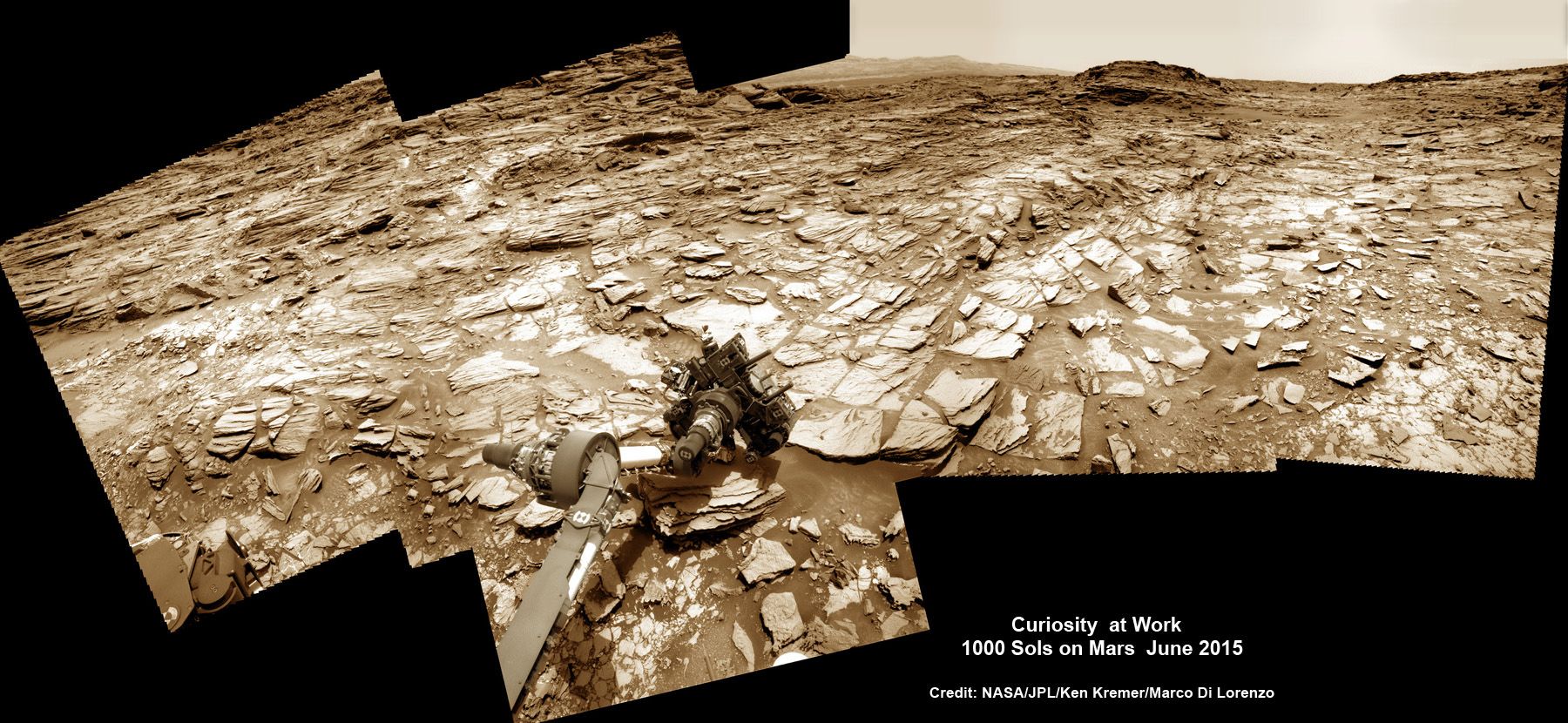
Curiosity rover at work for 1000 Sols on Mars.  This composite multi sol photo mosaic shows outstretched robotic arm inspecting intriguing rock outcrops.   The APXS spectrometer is investigating a target called ‘Ronan’ on the Stimson overlying outcrop.   Navcam camera raw images taken from sols 997 to 1000 are stitched and colorized.  Credit: NASA/JPL/Ken Kremer/kenkremer.com/Marco Di Lorenzo
Curiosity rover at work for 1000 Sols on Mars
This composite multi sol photo mosaic shows outstretched robotic arm inspecting intriguing rock outcrops. The APXS spectrometer is investigating a target called ‘Ronan’ on the Stimson overlying outcrop. Navcam camera raw images taken from sols 997 to 1000 are stitched and colorized. Credit: NASA/JPL/Ken Kremer/kenkremer.com/Marco Di Lorenzo

The raw images for the look back mosaic were taken after she arrived at her current location on Martian Sol 997, or Earth’s Day May 28, 2015.

The Curiosity Mars Science Laboratory (MSL) rover officially celebrated 1000 Martian Sols on May 31, 2015 since she safely touched down on the crater floor on August 5, 2012 following the nail-biting and unprecedented sky crane maneuver that delivered her with pinpoint precision to a landing site nearby Mount Sharp.

“An MSL landmark day. We have reached 1000 sols on Mars. Looking back the remarkable thing is how few serious problems there have been,” says team member Professor John Bridges of the University of Leicester, England, in an update.

Exploring the sedimentary layers of Mount Sharp, which towers 3.4 miles (5.5 kilometers) into the Martian sky, form the primary destination and goal of her scientific expedition.

The six wheeled robot and her team of handlers back on Earth, are eeking out every last drop of science before she and all of Earth’s entire Martian invasion fleet enter solar conjunction, when Mars is behind the sun and little or no communications will be possible for most of the month of June. Activities will be limited per safety protocols.

“However, there is one issue even Curiosity can’t avoid – Conjunction. For much of June, Mars will be obscured from Earth by the Sun. Few science operations,” explains Bridges.

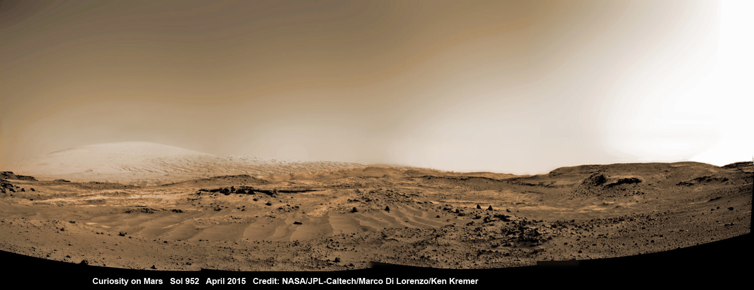
Curiosity rover rolls across Mars at the foothills of Mount Sharp, seen in the background, in this mosaic of images taken on April 11, 2015 (Sol 952).  Navcam camera raw images stitched and colorized. Credit:  NASA/JPL-Caltech/ Marco Di Lorenzo/Ken Kremer/kenkremer.com
Curiosity rover rolls across Mars at the foothills of Mount Sharp, seen in the background, in this mosaic of images taken on April 11, 2015 (Sol 952). Navcam camera raw images stitched and colorized. Credit: NASA/JPL-Caltech/ Marco Di Lorenzo/Ken Kremer/kenkremer.com

NASA’s long-lived Opportunity rover labors on the opposite side of Mars.

After a short drive Curiosity arrived at her current location at “Marias Pass” on Sol 997, where she will stay stationary during the conjunction period out of an abundance of caution.

“A short bump on Sol 997 put Curiosity in a great position to investigate a few different rock units in Marias Pass, using the instruments on the rover’s arm,” wrote MSL and USGS mission scientist Ken Herkenhoff in an update.

She also reached within an eyelash of 10.6 kilometers (6.6 mi) of total driving.

“The 2.5 m drive brings our total odometry to 10,599 m,” noted Herkenoff.

Along the way she discovered the chemical ingredient minerals necessary to support life, as well as low levels of some organic molecules and some traces of methane, and and ample evidence for lakes and streams of liquid water.

“Curiosity is now parked for the next few weeks. But we are parked in front of a beautiful outcrop that shows the contact between the underlying Pahrump unit and the overlying Stimson unit.”

Our arm photo mosaic herein shows the seven foot (2 m) long robotic arm and its APXS spectrometer deployed at the target called “Ronan”, which is part of the overlying Stimson outcrop unit.

The rover is also using the ChemCam, MastCam and MAHLI cameras and spectrometers and other instruments to characterize the outcrop and its texture and composition in detail.

The robotic arm will be stowed during the June conjunction period.

Curiosity arrived at the Pahrump Hills at the base of Mount Sharp back in September 2014. Since then she has conducted an intensive investigation of the rocks and a trio of drilling operations to elucidate how this area fits in context with Mount Sharp and the habitable region discovered on the crater floor at Yellowknife Bay back in the spring of 2013.

In recent weeks, Curiosity has been driving up hills with slopes of as much as 21 degrees, higher than ever before, on an exciting journey endeavoring to slowly ascend up to the lower layers of Mount Sharp.

The current Martian outcrop area under investigation is a place where two distinctive geologic types of bedrock meet and where pale rock meets darker overlying rock.

“Such contacts can reveal clues about how the environmental conditions that produced one type of rock were related to the conditions that produced the other,” says NASA.

“The rover science team wants to examine an outcrop that contains the contact between the pale rock unit the mission analyzed lower on Mount Sharp and a darker, bedded rock unit that the mission has not yet examined up close.”

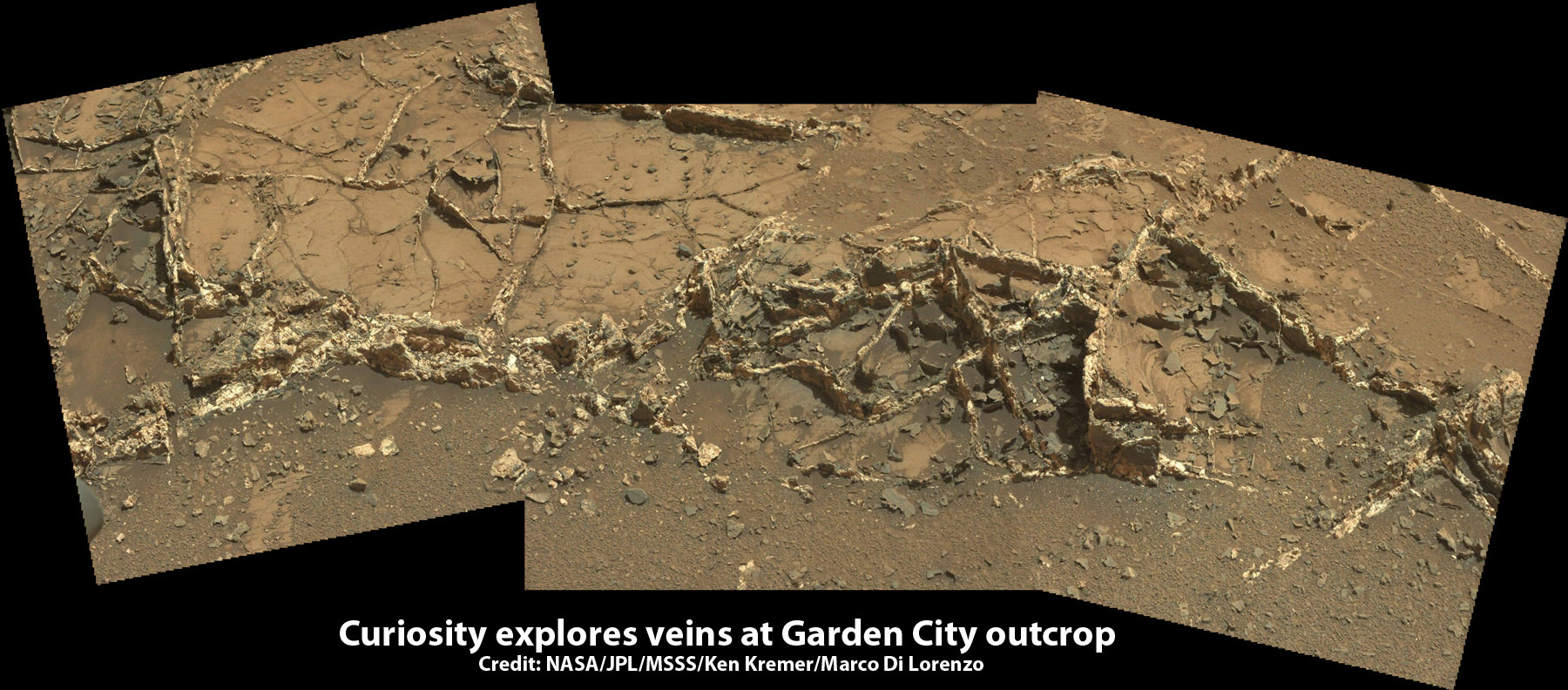
The team is also scouting around for the presence of mineral veins, like those recently discovered at the “Garden City” outcrop, that formed in the past during periods of flowing liquid water that could be favorable for microbial life forms if they ever existed.

Curiosity investigates a beautiful outcrop of scientifically enticing dark and light mineral veins at ”Garden City” outcrop at the base of Mount Sharp at current location on Mars.   This  photo mosaic was stitched  from Mastcam color camera raw images. Credit:  NASA/JPL-Caltech/MSSS/Ken Kremer/kenkremer.com/Marco Di Lorenzo
Curiosity investigates a beautiful outcrop of scientifically enticing dark and light mineral veins at ”Garden City” outcrop at the base of Mount Sharp at current location on Mars. This photo mosaic was stitched from Mastcam color camera raw images. Credit: NASA/JPL-Caltech/MSSS/Ken Kremer/kenkremer.com/Marco Di Lorenzo

Because there’s a plethora of treacherous dunes, the team has had to monitor operations carefully and alter the route on occasion to maintain safe operations.

Curiosity has already accomplished her primary objective of discovering a habitable zone on the Red Planet that contains the minerals necessary to support microbial life in the ancient past when Mars was far wetter and warmer billions of years ago.

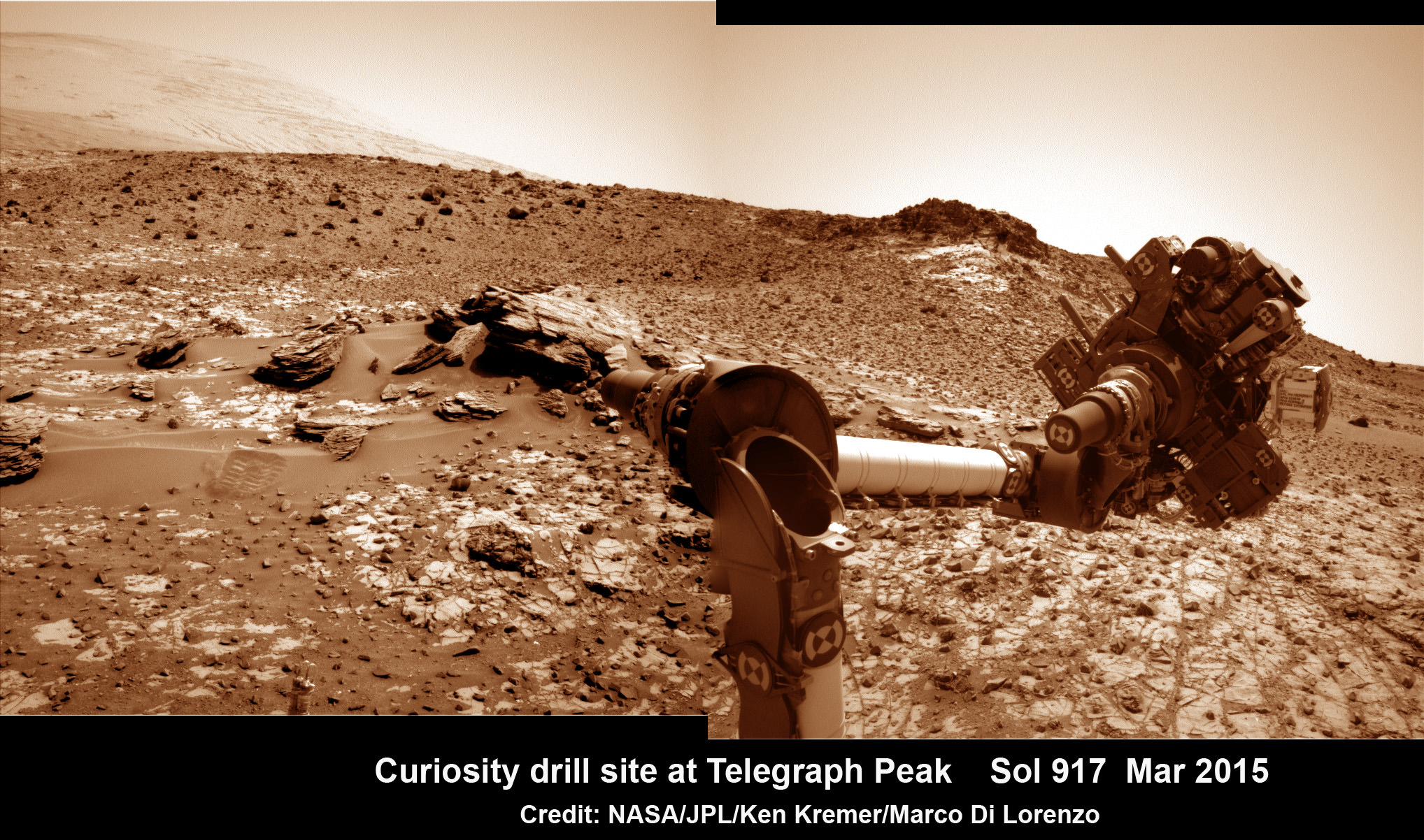
This March 6, 2015 (Sol 917), mosaic of images from the Navcam camera on NASA's Curiosity Mars rover shows the position in which the rover held its arm for several days after a transient short circuit triggered onboard fault-protection programming to halt arm activities on Feb. 27, 2015, Sol 911.  The rover team chose to hold the arm in the same position for several days of tests to diagnose the underlying cause of the Sol 911 event.  Navcam camera raw images stitched and colorized. Credit:  NASA/JPL-Caltech/Ken Kremer/kenkremer.com/Marco Di Lorenzo
This March 6, 2015 (Sol 917), mosaic of images from the Navcam camera on NASA’s Curiosity Mars rover shows the position in which the rover held its arm for several days after a transient short circuit triggered onboard fault-protection programming to halt arm activities on Feb. 27, 2015, Sol 911. The rover team chose to hold the arm in the same position for several days of tests to diagnose the underlying cause of the Sol 911 event. Navcam camera raw images stitched and colorized. Credit: NASA/JPL-Caltech/Ken Kremer/kenkremer.com/Marco Di Lorenzo

To date, Curiosity’s odometer totals over 5.1 miles (8.4 kilometers) since landing inside Gale Crater on Mars in August 2012.

As of today, Sol 1001, June 1, 2015, she has taken over 246,000 amazing images.

Stay tuned here for Ken’s continuing Earth and planetary science and human spaceflight news.
Ken Kremer

NASA Selects Mission Science Instruments Searching for Habitability of Jupiter’s Ocean Moon Europa

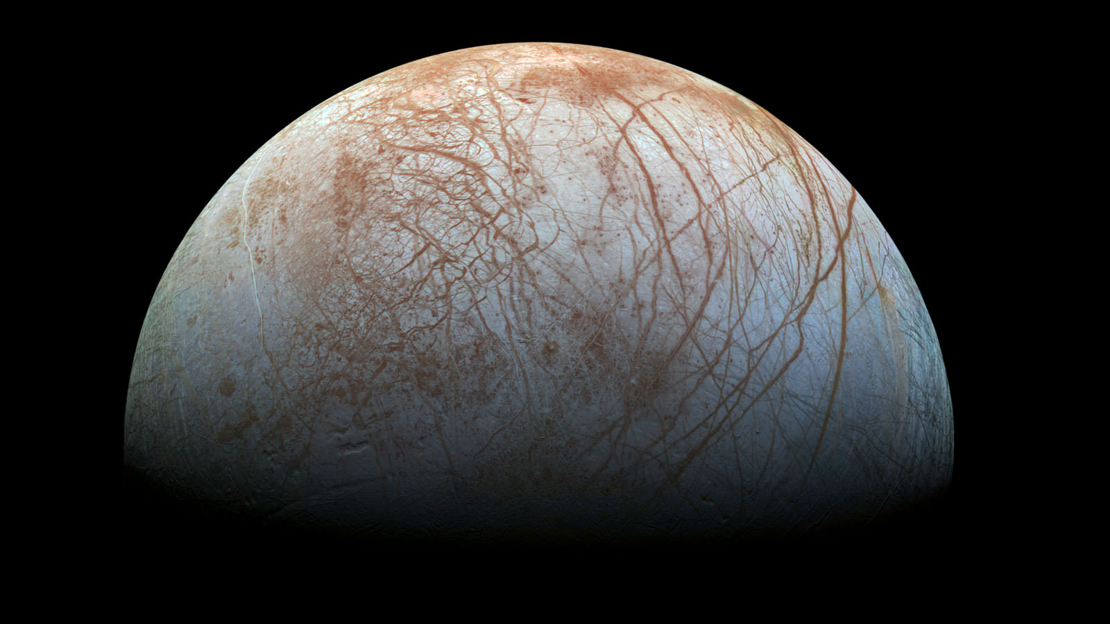
The fascinating surface of Jupiter’s icy moon Europa looms large in this newly-reprocessed color view, made from images taken by NASA's Galileo spacecraft in the late 1990s. This is the color view of Europa from Galileo that shows the largest portion of the moon's surface at the highest resolution. Credits: NASA/JPL-Caltech/SETI Institute

In a major move forward on a long dreamed of mission to investigate the habitability of the subsurface ocean of Jupiter’s mysterious moon Europa, top NASA officials announced today, Tuesday, May 26, the selection of nine science instruments that will fly on the agency’s long awaited planetary science mission to an intriguing world that many scientists suspect could support life.

“We are on our way to Europa,” proclaimed John Grunsfeld, associate administrator for NASA’s Science Mission Directorate in Washington, at a media briefing today outlining NASA’s plans for a mission dedicated to launching in the early to mid-2020s. “It’s a mission to inspire.”

“We are trying to answer big questions. Are we alone?”

“The young surface seems to be in contact with an undersea ocean.”

The Europa mission goal is to investigate whether the tantalizing icy Jovian moon, similar in size to Earth’s moon, could harbor conditions suitable for the evolution and sustainability of life in the suspected ocean.

It will be equipped with high resolution cameras, radar and spectrometers, several generations beyond anything before to map the surface in unprecedented detail and determine the moon’s composition and subsurface character. And it will search for subsurface lakes and seek to sample erupting vapor plumes like those occurring today on Saturn’s tiny moon Enceladus.

“Europa has tantalized us with its enigmatic icy surface and evidence of a vast ocean, following the amazing data from 11 flybys of the Galileo spacecraft over a decade ago and recent Hubble observations suggesting plumes of water shooting out from the moon,” says Grunsfeld.

“We’re excited about the potential of this new mission and these instruments to unravel the mysteries of Europa in our quest to find evidence of life beyond Earth.”

Planetary scientists have long desired a speedy return on Europa, ever since the groundbreaking discoveries of NASA’s Galileo Jupiter orbiter in the 1990s showed that the alien world possessed a substantial and deep subsurface ocean beneath an icy shell that appears to interact with and alter the surface in recent times.

This 12-frame mosaic provides the highest resolution view ever obtained of the side of Jupiter's moon Europa that faces the giant planet. It was obtained on Nov. 25, 1999 by the camera onboard the Galileo spacecraft, a past NASA mission to Jupiter and its moons. Credit: NASA/JPL/University of Arizona
This 12-frame mosaic provides the highest resolution view ever obtained of the side of Jupiter’s moon Europa that faces the giant planet. It was obtained on Nov. 25, 1999 by the camera onboard the Galileo spacecraft, a past NASA mission to Jupiter and its moons. Credit: NASA/JPL/University of Arizona

NASA’s Europa mission would blastoff perhaps as soon as 2022, depending on the budget allocation and rocket selection, whose candidates include the heavy lift Space Launch System (SLS).

The solar powered probe will go into orbit around Jupiter for a three year mission.

“The mission concept is that it will conduct multiple flyby’s of Europa,” said Jim Green. director, Planetary Science Division, NASA Headquarters, during the briefing.

“The purpose is to determine if Europa is a habitable place. It shows few craters, a brown gum on the surface and cracks where the subsurface meet the surface. There may be organics and nutrients among the discoloration at the surface.”

Europa is at or near the top of the list for most likely places in our solar system that could support life. Mars is also near the top of the list and currently being explored by a fleet of NASA robotic probes including surface rovers Curiosity and Opportunity.

“Europa is one of those critical areas where we believe that the environment is just perfect for potential development of life,” said Green. “This mission will be that step that helps us understand that environment and hopefully give us an indication of how habitable the environment could be.”

The exact thickness of Europa’s ice shell and extent of its subsurface ocean is not known.

The ice shell thickness has been inferred by some scientists to be perhaps only 5 to 10 kilometers thick based on data from Galileo, the Hubble Space Telescope, a Cassini flyby and other ground and space based observations.

The global ocean might be twice the volume of all of Earth’s water. Research indicates that it is salty, may possess organics, and has a rocky sea floor. Tidal heating from Jupiter could provide the energy for mixing and chemical reactions, supplemented by undersea volcanoes spewing heat and minerals to support living creatures, if they exist.

This artist's rendering shows a concept for a future NASA mission to Europa in which a spacecraft would make multiple close flybys of the icy Jovian moon, thought to contain a global subsurface ocean.  Credits: NASA/JPL-Caltech
This artist’s rendering shows a concept for a future NASA mission to Europa in which a spacecraft would make multiple close flybys of the icy Jovian moon, thought to contain a global subsurface ocean. Credits: NASA/JPL-Caltech

“Europa could be the best place in the solar system to look for present day life beyond our home planet,” says NASA officials.

The instruments chosen today by NASA will help answer the question of habitability, but they are not life detection instruments in and of themselves. That would require a follow on mission.

“They could find indications of life, but they’re not life detectors,” said Curt Niebur, Europa program scientist at NASA Headquarters in Washington. “We currently don’t even have consensus in the scientific community as to what we would measure that would tell everybody with confidence this thing you’re looking at is alive. Building a life detector is incredibly difficult.”

‘During the three year mission, the orbiter will conduct 45 close flyby’s of Europa,” Niebur told Universe Today. “These will occur about every two to three weeks.”

The close flyby’s will vary in altitude from 16 miles to 1,700 miles (25 kilometers to 2,700 kilometers).

“The mass spectrometer has a range of 1 to 2000 daltons, Niebur told me. “That’s a much wider range than Cassini. However there will be no means aboard to determine chirality.” The presence of Chiral compounds could be an indicator of life.

Right now the Europa mission is in the formulation stage with a budget of about $10 million this year and $30 Million in 2016. Over the next three years the mission concept will be defined.

The mission is expected to cost in the range of at least $2 Billion or more.

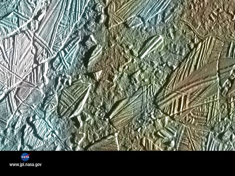
Jupiter Moon Europa, Ice Rafting View

Here’s a NASA description of the 9 instruments selected:

Plasma Instrument for Magnetic Sounding (PIMS) — principal investigator Dr. Joseph Westlake of Johns Hopkins Applied Physics Laboratory (APL), Laurel, Maryland. This instrument works in conjunction with a magnetometer and is key to determining Europa’s ice shell thickness, ocean depth, and salinity by correcting the magnetic induction signal for plasma currents around Europa.

Interior Characterization of Europa using Magnetometry (ICEMAG)
— principal investigator Dr. Carol Raymond of NASA’s Jet Propulsion Laboratory (JPL), Pasadena, California. This magnetometer will measure the magnetic field near Europa and – in conjunction with the PIMS instrument – infer the location, thickness and salinity of Europa’s subsurface ocean using multi-frequency electromagnetic sounding.


Mapping Imaging Spectrometer for Europa (MISE)
— principal investigator Dr. Diana Blaney of JPL. This instrument will probe the composition of Europa, identifying and mapping the distributions of organics, salts, acid hydrates, water ice phases, and other materials to determine the habitability of Europa’s ocean.

Europa Imaging System (EIS) — principal investigator Dr. Elizabeth Turtle of APL. The wide and narrow angle cameras on this instrument will map most of Europa at 50 meter (164 foot) resolution, and will provide images of areas of Europa’s surface at up to 100 times higher resolution.

Radar for Europa Assessment and Sounding: Ocean to Near-surface (REASON) — principal investigator Dr. Donald Blankenship of the University of Texas, Austin. This dual-frequency ice penetrating radar instrument is designed to characterize and sound Europa’s icy crust from the near-surface to the ocean, revealing the hidden structure of Europa’s ice shell and potential water within.

Europa Thermal Emission Imaging System (E-THEMIS) — principal investigator Dr. Philip Christensen of Arizona State University, Tempe. This “heat detector” will provide high spatial resolution, multi-spectral thermal imaging of Europa to help detect active sites, such as potential vents erupting plumes of water into space.

MAss SPectrometer for Planetary EXploration/Europa (MASPEX) — principal investigator Dr. Jack (Hunter) Waite of the Southwest Research Institute (SwRI), San Antonio. This instrument will determine the composition of the surface and subsurface ocean by measuring Europa’s extremely tenuous atmosphere and any surface material ejected into space.

Ultraviolet Spectrograph/Europa (UVS) — principal investigator Dr. Kurt Retherford of SwRI. This instrument will adopt the same technique used by the Hubble Space Telescope to detect the likely presence of water plumes erupting from Europa’s surface. UVS will be able to detect small plumes and will provide valuable data about the composition and dynamics of the moon’s rarefied atmosphere.

SUrface Dust Mass Analyzer (SUDA) — principal investigator Dr. Sascha Kempf of the University of Colorado, Boulder. This instrument will measure the composition of small, solid particles ejected from Europa, providing the opportunity to directly sample the surface and potential plumes on low-altitude flybys.

Stay tuned here for Ken’s continuing Earth and planetary science and human spaceflight news.
Ken Kremer

Opportunity Rover Team Honors Pioneering Lindbergh Flight at Mars Mountaintop Crater

Martian Reminder of a Pioneering Flight. Names related to the first solo nonstop flight across the Atlantic have been informally assigned to a crater NASA's Opportunity Mars rover is studying. This false-color view of the "Spirit of St. Louis Crater" and the "Lindbergh Mound" inside it comes from Opportunity's panoramic camera. Image Credit: NASA/JPL-Caltech/Cornell Univ./Arizona State Univ.

Martian Reminder of a Pioneering Flight. Names related to the first solo nonstop flight across the Atlantic have been informally assigned to a crater NASA’s Opportunity Mars rover is studying. This false-color view of the “Spirit of St. Louis Crater” and the “Lindbergh Mound” inside it comes from Opportunity’s panoramic camera. Image Credit: NASA/JPL-Caltech/Cornell Univ./Arizona State Univ.
See additional Opportunity photo mosaics below [/caption]

The science team leading NASA’s long-lived Opportunity rover mission is honoring the pioneering solo nonstop trans-Atlantic flight of aviator Charles Lindbergh by assigning key features of the Mars mountain top crater area the rover is now exploring with names related to the historic flight.

Opportunity is now studying an elongated crater called “Spirit of St. Louis” and an unparalleled rock spire within the crater called “Lindbergh Mound” which are named in honor of Lindbergh himself and his plane – the Spirit of Saint Louis.

“Spirit of Saint Louis” crater is quite special in many ways related not just to history but also to science and exploration – that very reasons behind Lindbergh’s flight and Opportunity’s astounding mission to the Red Planet.

The team is ecstatic that the 11 year old rover Opportunity has reached “Spirit of St. Louis Crater” because its serves as the gateway to the alien terrain of “Marathon Valley” holding caches of water altered minerals that formed under environmental conditions conducive to support Martian microbial life forms, if they ever existed.

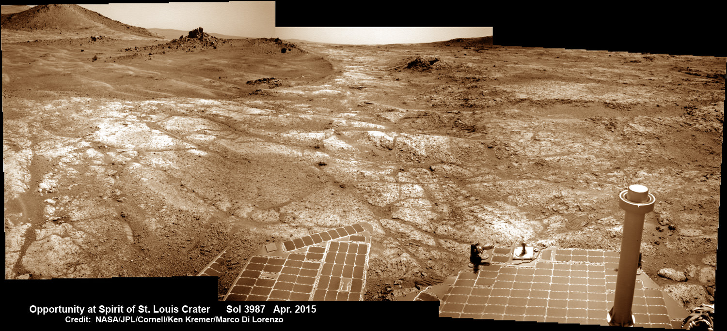
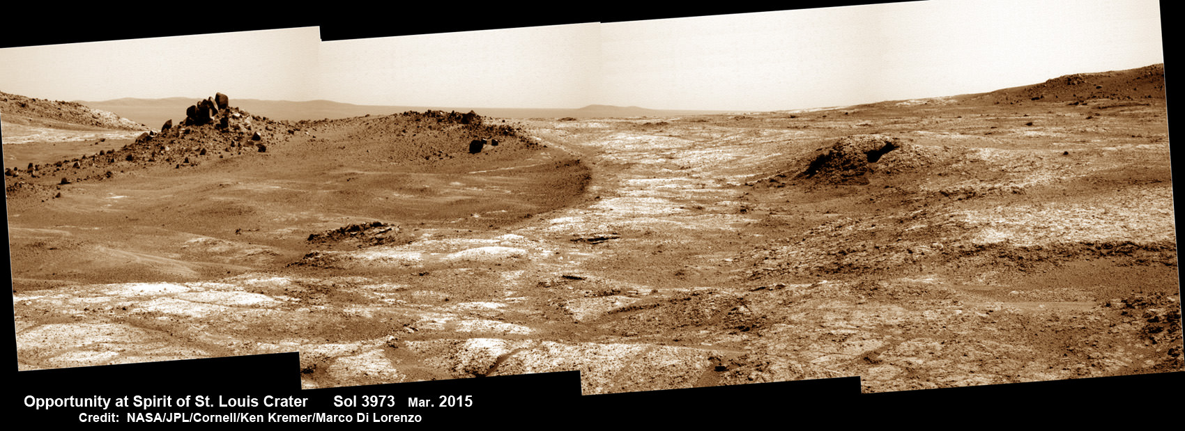
The crater, rock spire and several features in and near it are shown in several recent panoramic mosaics, above and below, created by the rover team and separately by the image processing team of Ken Kremer and Marco Di Lorenzo.

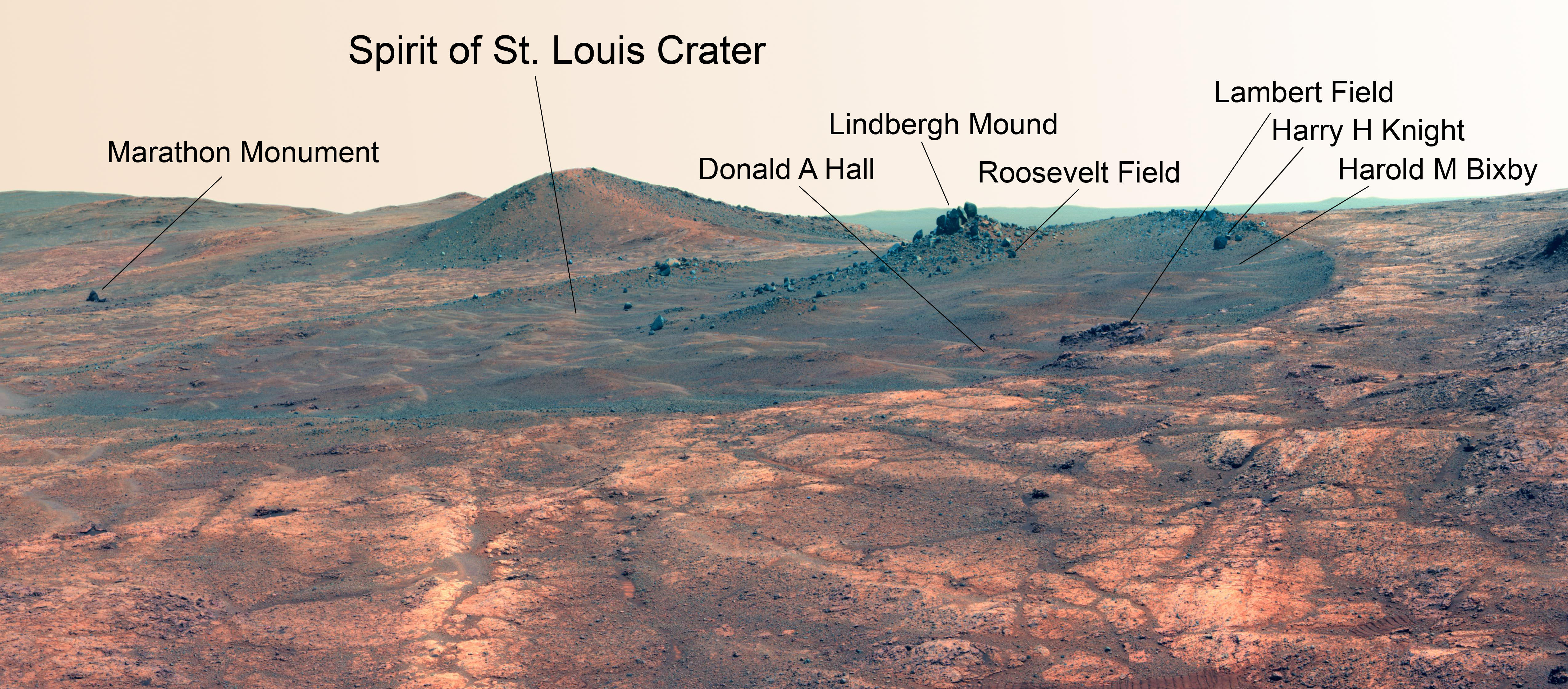
Opportunity’s view (annotated) on the day the NASA rover exceeded the distance of a marathon on the surface of Mars on March 24, 2015, Sol 3968 with features named in honor of Charles Lindbergh’s historic solo flight across the Atlantic Ocean in 1927. Rover stands at Spirit of Saint Louis Crater near mountaintop at Marathon Valley overlook and Martian cliffs at Endeavour crater holding deposits of water altered clay minerals.  This navcam camera photo mosaic was assembled from images taken on Sol 3968 (March 24, 2015) and colorized.  Credit: NASA/JPL/Cornell/Marco Di Lorenzo/Ken Kremer/kenkremer.com
Opportunity’s view (annotated) on the day the NASA rover exceeded the distance of a marathon on the surface of Mars on March 24, 2015, Sol 3968 with features named in honor of Charles Lindbergh’s historic solo flight across the Atlantic Ocean in 1927. Rover stands at Spirit of Saint Louis Crater near mountaintop at Marathon Valley overlook and Martian cliffs at Endeavour crater holding deposits of water altered clay minerals. This navcam camera photo mosaic was assembled from images taken on Sol 3968 (March 24, 2015) and colorized. Credit: NASA/JPL/Cornell/Marco Di Lorenzo/Ken Kremer/kenkremer.com

Marathon Valley and Spirit of St. Louis Crater are located just a few hundred meters south of a Mars mountain summit at a majestic spot called Cape Tribulation. It lies along a marvelous ridgeline along the western rim of Endeavour crater, which spans some 22 kilometers (14 miles) in diameter.

“What’s the connection between St. Louis and the Spirit of St. Louis? Lindbergh flew from New York to Paris, but he named his aircraft for the St. Louis citizens who purchased it for him,” says Prof. Ray Arvidson, the rover Deputy Principal Investigator of Washington University in St. Louis.

The raw images for the mosaics were taken in March and April 2015 using the robots mast mounted pancam and navcam cameras. The mosaics are shown in false color and colorized versions, annotated and unannotated.

Charles Lindbergh embarked in May 1927 on his history making flight from New York to Paris in the airplane he named Spirit of St. Louis, the first solo nonstop flight across the Atlantic.

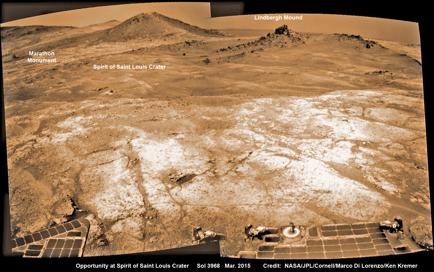
Opportunity at Spirit of Saint Louis crater scanning into Marathon Valley and Endeavour crater from current location on Mars in April 2015 in this photo mosaic.  The crater, featuring an odd mound of rocks now named Lingbergh Mound, is the gateway to Marathon Valley and exposures of water altered clay minerals.  This navcam camera photo mosaic was assembled from images taken on Sol 3987 (April 12, 2015) and colorized.  Credit: NASA/JPL/Cornell/ Ken Kremer/kenkremer.com/Marco Di Lorenzo
Opportunity at Spirit of Saint Louis crater scanning into Marathon Valley and Endeavour crater from current location on Mars in April 2015 in this photo mosaic. The crater, featuring an odd mound of rocks now named Lingbergh Mound, is the gateway to Marathon Valley and exposures of water altered clay minerals. This navcam camera photo mosaic was assembled from images taken on Sol 3987 (April 12, 2015) and colorized. Credit: NASA/JPL/Cornell/ Ken Kremer/kenkremer.com/Marco Di Lorenzo

The shallow Spirit of St. Louis Crater is about 110 feet (34 meters) long and about 80 feet (24 meters) wide, with a floor slightly darker than surrounding terrain, says NASA.

Lindbergh Mound dominates the crater measuring about 7 to 10 feet (2 to 3 meters) tall, rising higher than the crater’s rim.

The annotations also include features named to recognize the financial backing for the flight from St. Louis residents including Harold M. Bixby and Harry M. Knight. The plane’s designer was Donald A. Hall.

Opportunity arrives at Spirit of Saint Louis crater and peers into Marathon Valley and Endeavour crater from current location on Mars as of April 3, 2015 in this photo mosaic.  The crater, featuring an odd mound of rocks now named Lingbergh Mound,  is the gateway to Marathon Valley and exposures of water altered clay minerals.  This pancam camera photo mosaic was assembled from images taken on Sol 3973 (March 29, 2015) and colorized.  Credit: NASA/JPL/Cornell/ Ken Kremer/kenkremer.com/Marco Di Lorenzo
Opportunity arrives at Spirit of Saint Louis crater and peers into Marathon Valley and Endeavour crater from current location on Mars as of April 3, 2015 in this photo mosaic. The crater, featuring an odd mound of rocks now named Lingbergh Mound, is the gateway to Marathon Valley and exposures of water altered clay minerals. This pancam camera photo mosaic was assembled from images taken on Sol 3973 (March 29, 2015) and colorized. Credit: NASA/JPL/Cornell/ Ken Kremer/kenkremer.com/Marco Di Lorenzo

Among other features named are Roosevelt Field, the spot on New York’s Long Island from which Lindbergh took off, and Marathon Monument, where the rover completed a her first marathon distance runners drive on Mars. The team picked a distinctive outcrop, Marathon Monument, to mark the finish line, said NASA officials.

“The science team for the rover picks crater names from a list of “vessels of exploration,” including ships of sail and spacecraft as well as aircraft. As long as the rover remains in the crater, names for interesting features will drawn from a list of names related to this famous flight,” according to a NASA statement.

Stay tuned here for Ken’s continuing Earth and planetary science and human spaceflight news.
Ken Kremer

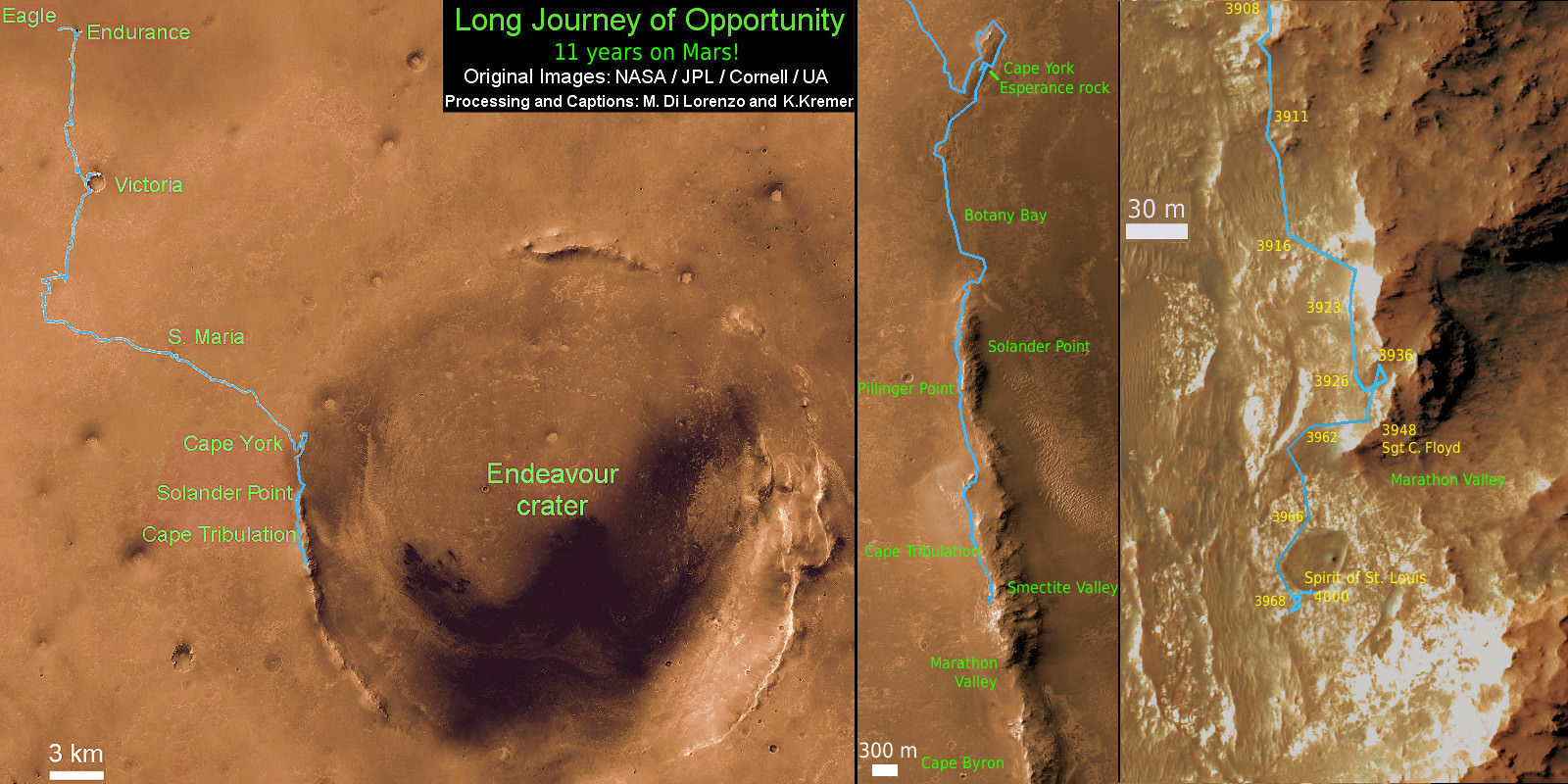
11 Year Traverse Map for NASA’s Opportunity rover from 2004 to 2015. This map shows the entire path the rover has driven during 11 years and three months and a marathon runners distance on Mars for over 4000 Sols, or Martian days, since landing inside Eagle Crater on Jan 24, 2004 -to current location just past the Cape Tribulation summit at the western rim of Endeavour Crater at Marathon Valley. Rover surpassed Marathon distance on Sol 3968 and marked 11th Martian anniversary on Sol 3911. Opportunity discovered clay minerals at Esperance – indicative of a habitable zone - and is searching for more on the road ahead at Marathon Valley.  Credit: NASA/JPL/Cornell/ASU/Marco Di Lorenzo/Ken Kremer – kenkremer.com
11 Year Traverse Map for NASA’s Opportunity rover from 2004 to 2015. This map shows the entire path the rover has driven during 11 years and three months and a marathon runners distance on Mars for over 4000 Sols, or Martian days, since landing inside Eagle Crater on Jan 24, 2004 -to current location just past the Cape Tribulation summit at the western rim of Endeavour Crater at Marathon Valley. Rover surpassed Marathon distance on Sol 3968 and marked 11th Martian anniversary on Sol 3911. Opportunity discovered clay minerals at Esperance – indicative of a habitable zone – and is searching for more on the road ahead at Marathon Valley. Credit: NASA/JPL/Cornell/ASU/Marco Di Lorenzo/Ken Kremer – kenkremer.com

India’s MOM Captures First Image of the Red Planet

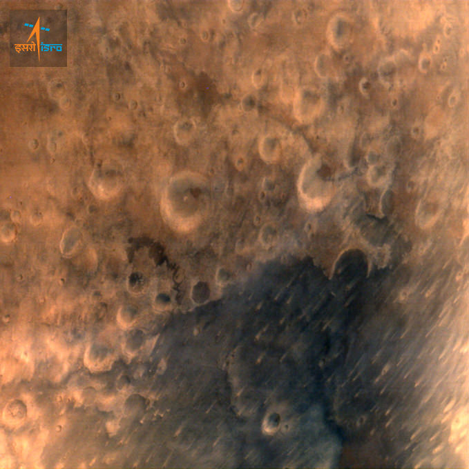
ISRO's Mars Orbiter Mission captures its first image of Mars from a height of 7300 km. Credit: ISRO

India’s “history creating” maiden interplanetary voyager, the Mars Orbiter Mission (MOM) has captured her historic first image of the Red Planet.

The Indian Space Research Organization (ISRO), India’s space agency which designed and developed the orbiter released the image today, Sept 25, just a day after MOM successfully arrived at Mars on Sept. 23/24.

Read my complete MOM meets Mars arrival story – here.

The image was taken by the probe’s Mars Colour Camera (MCC), tri color imager, from a height of 7300 kilometers with a spatial resolution of 376 meters and shows a heavily cratered region on the Red Planet.

Following MOM’s successful orbital insertion maneuver, India joined an elite club of only three other entities who have launched probes that successfully investigated Mars – following the Soviet Union, the United States, and the European Space Agency (ESA).

MOM is now circling Mars in a highly elliptical orbit whose nearest point to Mars (periapsis) is at 421.7 km and farthest point (apoapsis) at 76,993.6 km. The inclination of orbit with respect to the equatorial plane of Mars is 150 degrees, as intended, ISRO reports.

By way of comparison, here’s the first image taken by MOM of the Blue Planet, her Home World.

First ever image of Earth Taken by Mars Color Camera aboard India’s Mars Orbiter Mission (MOM) spacecraft while orbiting Earth and before the Trans Mars Insertion firing on Dec. 1, 2013. Image is focused on the Indian subcontinent.  Credit: ISRO
First ever image of Earth Taken by Mars Color Camera aboard India’s Mars Orbiter Mission (MOM) spacecraft while orbiting Earth and before the Trans Mars Insertion firing on Dec. 1, 2013. Image is focused on the Indian subcontinent. Credit: ISRO

Stay tuned here for Ken’s continuing Earth and planetary science and human spaceflight news.
Ken Kremer

Comet’s Head Selected as Landing Site for Rosetta’s Historic Philae Lander

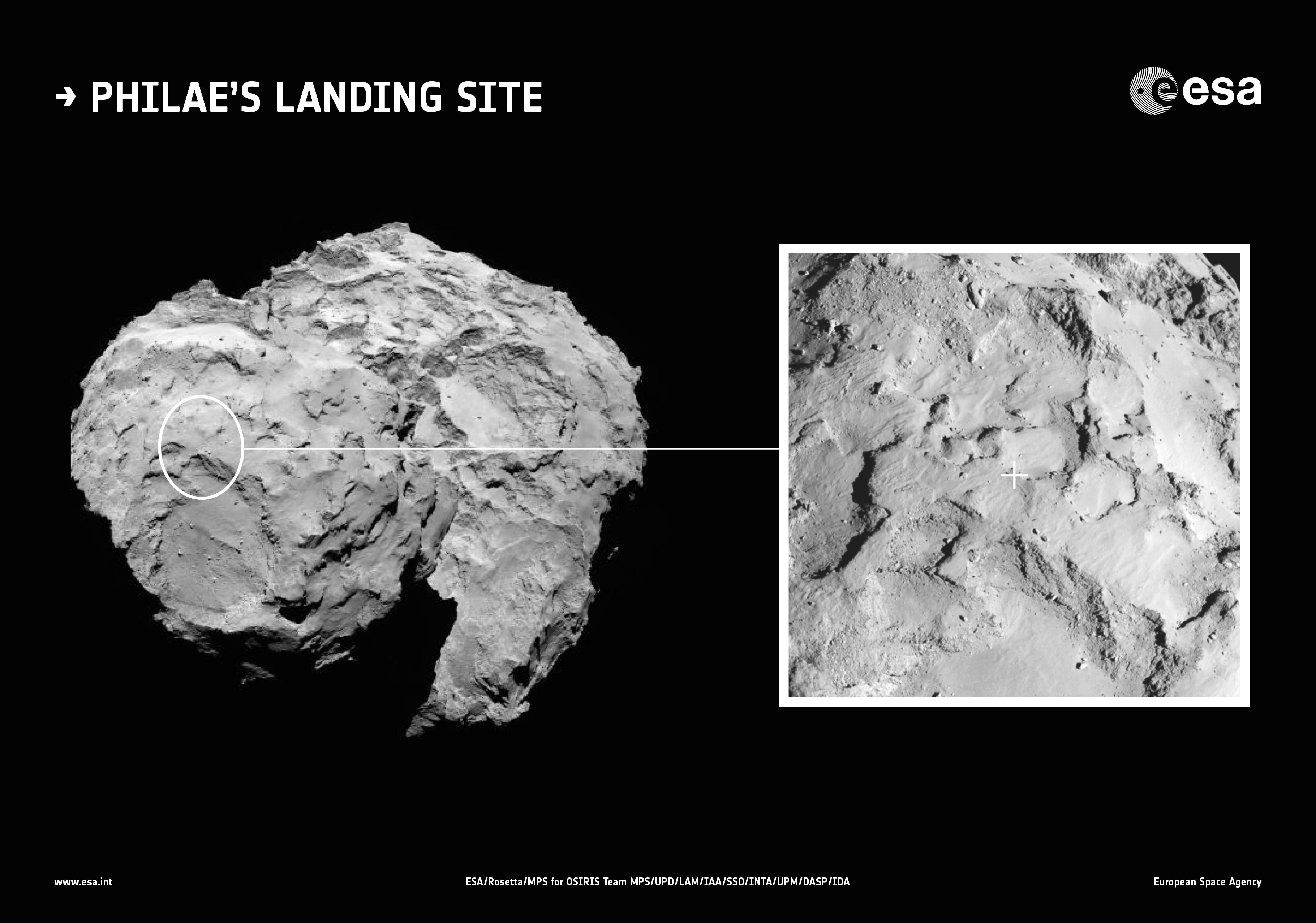
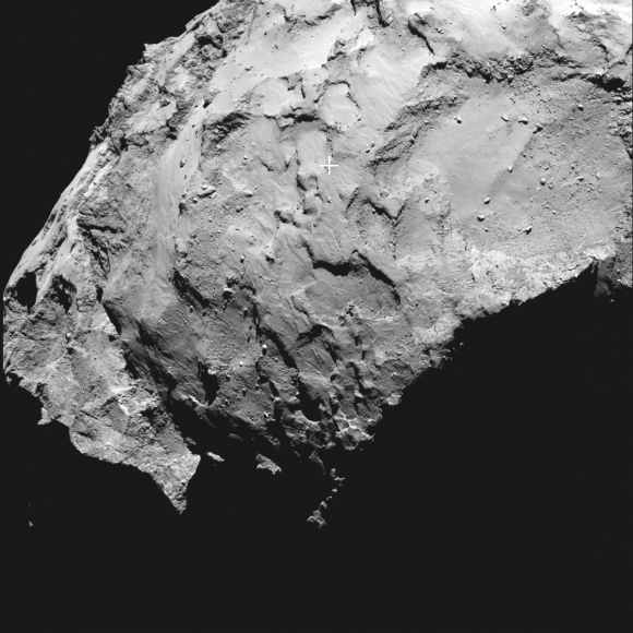
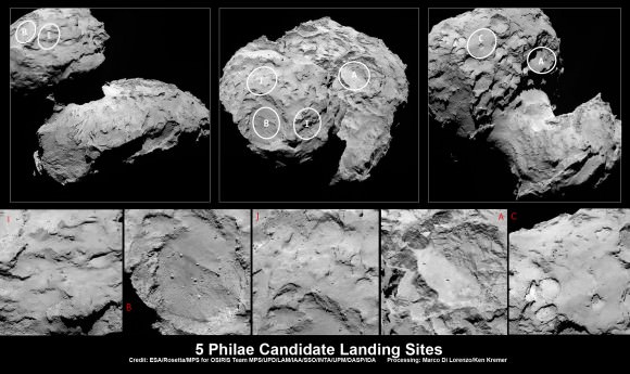
Context image showing the location of the primary landing site for Rosetta’s lander Philae. Site J is located on the head of Comet 67P/Churyumov–Gerasimenko. An inset showing a close up of the landing site is also shown. The inset image was taken by Rosetta’s OSIRIS narrow-angle camera on 20 August 2014 from a distance of about 67 km. The image scale is 1.2 metres/pixel. The background image was taken on 16 August from a distance of about 100 km. Credits: ESA/Rosetta/MPS for OSIRIS Team MPS/UPD/LAM/IAA/SSO/INTA/UPM/DASP/IDA

The ‘head’ of the bizarre comet 67P/Churyumov-Gerasimenko has been selected as the primary landing site for the Rosetta spacecraft’s attached Philae lander, attempting mankind’s first ever landing on a comet in mid-November.

Scientists leading the European Space Agency’s Rosetta mission announced the primary landing site at a media briefing today, Sept. 15, at ESA headquarters.

After weeks of detailed study and debate focused on balancing scientific interest with finding a ‘technically feasible’ and safe Philae touchdown site, the team chose a target dubbed Site J as the primary landing site from among a list of five initially selected sites, said Stephan Ulamec, Philae Lander Manager at the DLR German Aerospace Center, at the briefing.

“Site J is the primary landing site around the head of the comet,” Ulamec announced.

“Site C is the backup site on the body [near the bottom of the comet].”

“This was not an easy task. Site J is a mix of flat areas and rough terrain. It’s not a perfectly flat area. There is still risk with high slope areas.”

Credits: ESA/Rosetta/MPS for OSIRIS Team MPS/UPD/LAM/IAA/SSO/INTA/UPM/DASP/IDA

He also made clear that there is still some landing uncertainty with the targeting of the lander onto the comet.

Site J is an intriguing region on Comet 67P/Churyumov–Gerasimenko that offers unique scientific potential, with hints of activity nearby, and minimum risk to the lander compared to the other candidate sites, according to ESA.

“As we have seen from recent close-up images, the comet is a beautiful but dramatic world – it is scientifically exciting, but its shape makes it operationally challenging,” says Ulamec.

“None of the candidate landing sites met all of the operational criteria at the 100% level, but Site J is clearly the best solution.”

Philae’s history-making landing on comet 67P is currently scheduled for around Nov. 11, 2014, and will be entirely automatic. The 100 kg lander is equipped with 10 science instruments.

“All of Rosetta’s instruments are supporting the landing site selection,” said Holger Sierks, principal investigator for Rosetta’s OSIRIS camera from the Max Planck Institute for Solar System Research in Gottingen, Germany.

“Site J is just 500-600 meters away from some pits and an area of comet outgassing activity. They will become more active as we get closer to the sun.

The team is in a race against time to select a suitable landing zone quickly and develop the complex landing sequence since the comet warms up and the surface becomes ever more active as it swings in closer to the sun and makes the landing ever more hazardous.

Since the descent to the comet is passive it is only possible to predict that the landing point will place within a ‘landing ellipse’ typically a few hundred metres in size, the team elaborated.

The three-legged lander will fire two harpoons and use ice screws to anchor itself to the 4 kilometer (2.5 mile) wide comet’s surface. Philae will collect stereo and panoramic images and also drill 20 to 30 centimeters into and sample its incredibly varied surface.

“We will make the first ever in situ analysis of a comet at this site, giving us an unparalleled insight into the composition, structure and evolution of a comet,” says Jean-Pierre Bibring, a lead lander scientist and principal investigator of the CIVA instrument at the IAS in Orsay, France.

“Site J in particular offers us the chance to analyse pristine material, characterise the properties of the nucleus, and study the processes that drive its activity.”

“It’s amazing how much we have learned so far.”

“We are in a true revolution of how we think Planets form and evolve,” Bibring elaborated at the briefing.

“We will make many types of scientific measurements of the comet from the surface. We will get a complete panoramic view of the comet on the macroscopic and microscopic scale.”

Rosetta is currently orbiting the comet from a distance of 30 km, said ESA Rosetta flight director Andrea Accomazzo. He said it will likely go even closer to 20 km and perhaps 10 km.

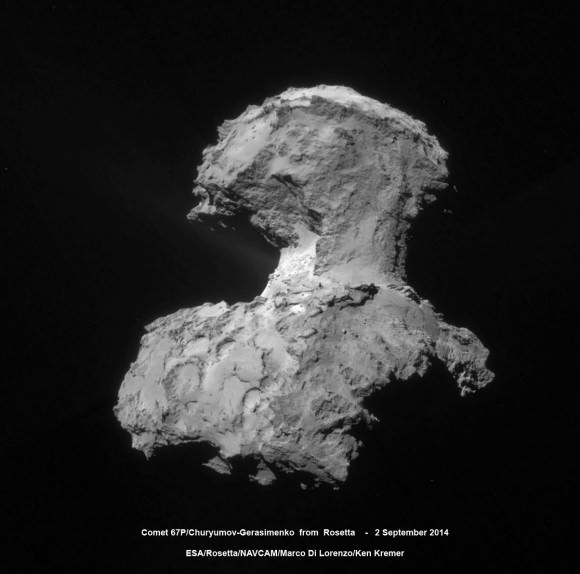
Four-image photo mosaic comprising images taken by Rosetta's navigation camera on 2 September 2014 from a distance of 56 km from comet 67P/Churyumov-Gerasimenko. The mosaic has been contrast enhanced to bring out details of the coma, especially of jets of dust emanating from the neck region. Credits: ESA/Rosetta/NAVCAM/Marco Di Lorenzo/Ken Kremer - kenkremer.com
Four-image photo mosaic comprising images taken by Rosetta’s navigation camera on 2 September 2014 from a distance of 56 km from comet 67P/Churyumov-Gerasimenko. The mosaic has been contrast enhanced to bring out details of the coma, especially of jets of dust emanating from the neck region. Credits: ESA/Rosetta/NAVCAM/Marco Di Lorenzo/Ken Kremer – kenkremer.com

“Now that we’re closer to the comet, continued science and mapping operations will help us improve the analysis of the primary and backup landing sites,” says ESA Rosetta flight director Andrea Accomazzo.

“Of course, we cannot predict the activity of the comet between now and landing, and on landing day itself. A sudden increase in activity could affect the position of Rosetta in its orbit at the moment of deployment and in turn the exact location where Philae will land, and that’s what makes this a risky operation.”

Four-image photo mosaic comprising images taken by Rosetta's navigation camera on 31 August 2014 from a distance of 61 km from comet 67P/Churyumov-Gerasimenko. The mosaic has been rotated and contrast enhanced to bring out details. The comet nucleus is about 4 km across. Credits: ESA/Rosetta/NAVCAM/Ken Kremer/Marco Di Lorenzo
Four-image photo mosaic comprising images taken by Rosetta’s navigation camera on 31 August 2014 from a distance of 61 km from comet 67P/Churyumov-Gerasimenko. The mosaic has been rotated and contrast enhanced to bring out details. The comet nucleus is about 4 km across. Credits: ESA/Rosetta/NAVCAM/Ken Kremer/Marco Di Lorenzo

The final landing site selections were made at a meeting being held this weekend on 13 and 14 September 2014 between the Rosetta Lander Team and the Rosetta orbiter team at CNES in Toulouse, France.

“No one has ever attempted to land on a comet before, so it is a real challenge,” says Fred Jansen, ESA Rosetta mission manager.

“The complicated ‘double’ structure of the comet has had a considerable impact on the overall risks related to landing, but they are risks worth taking to have the chance of making the first ever soft landing on a comet.”

Five candidate sites were identified on Comet 67P/Churyumov-Gerasimenko for Rosetta’s Philae lander.   The approximate locations of the five regions are marked on these OSIRIS narrow-angle camera images taken on 16 August 2014 from a distance of about 100 km. Enlarged insets below highlight 5 landing zones.  Credits: ESA/Rosetta/MPS for OSIRIS Team MPS/UPD/LAM/IAA/SSO/INTA/UPM/DASP/IDA  Processing: Marco Di Lorenzo/Ken Kremer
Five candidate sites were identified on Comet 67P/Churyumov-Gerasimenko for Rosetta’s Philae lander. The approximate locations of the five regions are marked on these OSIRIS narrow-angle camera images taken on 16 August 2014 from a distance of about 100 km. Enlarged insets below highlight 5 landing zones. Credits: ESA/Rosetta/MPS for OSIRIS Team MPS/UPD/LAM/IAA/SSO/INTA/UPM/DASP/IDA Processing: Marco Di Lorenzo/Ken Kremer

Stay tuned here for Ken’s continuing Rosetta, Earth and Planetary science and human spaceflight news.

Ken Kremer