The folks from UnmannedSpaceflight.com have been busy working on the new images of Phobos returned by Mars Express. Above, is an animation created by Daniel Machácek, who also colorized the images and processed them through some morphing software to make a seamless animation (via Emily Lakdawalla from the Planetary Blog), and below is another morphing animation by Daniel Brennan (via the Mars Express Blog)
Continue reading “Morphing Phobos”
Hartley 2 in Motion: Stunning Morph Animation of Flyby Images
The folks from UnmannedSpaceflight.com have done it again. Daniel Machácek created this wonderful animation from just the five initial images of Hartley 2 that were released by the Deep Impact team immediately following its flyby on November 4, 2010, using Sqirlz Morph software. Time in the animation is five times faster than the actual speed of the flyby. Hartley 2 really does look like a flying bowling pin, except this one is 2km (1.25 miles) long and about .2 km in diameter. Thanks to Daniel for sharing his animation.
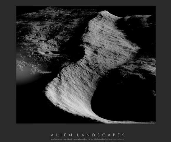
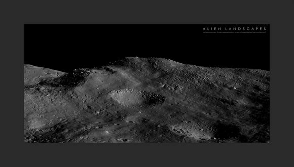
A New Look at the Moon: Stunning 3-D Lunar Landscapes

[/caption]
You may recall Bernhard Braun as the wizard from UnmannedSpaceflight.com who created the amazing 3-D images of the Mars avalanche. Now he’s created incredible planetary landscapes for a different world: the Moon. “Actually, this has been my very first attempt with lunar imagery after my previous work has almost been exclusively devoted to Mars,” Braun said. The special software he developed can create three dimensional images from one 2-dimensional picture, but he says the real stars are the spacecraft that gather the data, the Lunar Reconnaissance Orbiter and the Mars Reconnaissance Orbiter. “It is the unprecedented quality together with the unprecedented availability of the raw data that opens the door for everyone to explore new ideas and processing techniques,” Braun said.
See below for more stunning from-the-surface 3-D looks at the Moon – no special 3-D glasses needed!

I asked Braun if working with images from the Moon was different than working with Mars images. “Creating the single-image shading-derived DEMs from the Moon imagery is both easier and more difficult at the same time when compared to the same process applied to Mars images,” he said. “It’s easier because the lunar surface does not vary as much in its intrinsic albedo, i.e. the visible brightness variations are almost exclusively caused by variations in surface topography, especially at low illumination angles, which can be exploited by the reconstruction algorithm to derive high precision 3D geometry.”
But the work is more difficult because of the totally black shadows on the Moon due to lack of any atmosphere. “So on the Moon any shadows are virtually featureless areas where the 3-D reconstruction algorithm cannot infer anything about the structure of the invisible shadowed surface,” Braun said. “This is different on Mars, where the shadowed areas are usually lit indirectly by considerable amounts of ambient light scattered by dust particles suspended in the atmosphere. So the 3-D models of the Mars surface can be more complete, showing surface details even in shadowed areas.”

“All in all it’s a lot of fun to play around with both camera and sun positions until an interesting landscape shot is found,” Braun said. “I would like to add that much of the credit must really go to those true wizards at NASA/JPL for not only making and bringing to orbit these almost unearthly powerful cameras like LROC and HiRISE … but also for sharing the whole image catalog via the internet with everyone in the world!”
Braun said he hopes to tackle 3-D views of the Apollo landing sites — which we cannot wait to see!
Click on the images for links to higher resolution versions, or check out more of Braun’s Lunar Landscapes at this link. Our thanks to Bernhard for allowing us to post them on Universe Today
For more handiwork with images from space , check out UnmannedSpaceflight.com
Amazing Mars Flyover Videos Keep Getting Better and Better
How do the folks from UnmannedSpaceflight do it?!! They keep surpassing themselves with every new flyover video! We’ve posted some Mars flyover videos before, created by UMSF founder Doug Ellison. Now, colleague Adrian Lark — who has been working on creating animations and enhanced images with data from the Mars missions for several years — has produced new features on the videos. This latest, which flies you around the scarp surrounding Olympus Mons has speed and height information as well as a context map included on the video. “The data I am using is generated from the HiRISE camera onboard the Mars Reconnaissance Orbiter,” Adrian told me. “The elevation data has a spatial resolution of 1 meter and the image data has a spatial resolution of 25 centimeters. There is no vertical exaggeration in any of the videos.”
Also, Adrian has experimented with You Tube’s stereoscopic 3-D player, providing a 3-D experience of flying through Candor Chasma. IMAX, watchout! You’ve got competition!
So hang on while you watch these incredible videos! See more below, and also Adrian shared with me a little about his software and how he creates these flyover videos.
Continue reading “Amazing Mars Flyover Videos Keep Getting Better and Better”
