Why Doesn’t Earth Have More Water?

Water, water everywhere… Coleridge’s shipbound ancient mariners were plagued by a lack of water while surrounded by a sea of the stuff, and while 70% of Earth’s surface is indeed covered by water (of which 96% is salt water, hence not a drop to drink) there’s really not all that much — not when compared to the entire mass of the planet. Less than 1% of Earth is water, which seems odd to scientists because, based on conventional models of how the Solar System formed, there should have been a lot more water available in Earth’s neck of the woods when it was coming together. So the question has been floating around: why is Earth so dry?

According to a new study from the Space Telescope Science Institute in Baltimore, MD, the answer may lie in the snow.

The snow line, to be exact. The region within a planetary system beyond which temperatures are cold enough for water ice to exist, the snow line in our solar system is currently located in the middle of the main asteroid belt, between the orbits of Mars and Jupiter. Based on conventional models of how the Solar System developed, this boundary used to be closer in to the Sun, 4.5 billion years ago. But if that were indeed the case, then Earth should have accumulated much more ice (and therefore water) as it was forming, becoming a true “water world” with a water mass up to 40 percent… instead of a mere one.
As we can see today, that wasn’t the case.

Planets such as Uranus and Neptune that formed beyond the snow line are composed of tens of percents of water. But Earth doesn’t have much water, and that has always been a puzzle.”

– Rebecca Martin, Space Telescope Science Institute 

A study led astrophysicists Rebecca Martin and Mario Livio of the Space Telescope Science Institute took another look at how the snow line in our solar system must have evolved, and found that, in their models, Earth was never inside the line. Instead it stayed within a warmer, drier region inside of the snow line, and away from the ice.

“Unlike the standard accretion-disk model, the snow line in our analysis never migrates inside Earth’s orbit,” Livio said. “Instead, it remains farther from the Sun than the orbit of Earth, which explains why our Earth is a dry planet. In fact, our model predicts that the other innermost planets, Mercury, Venus, and Mars, are also relatively dry. ”

Read: Rethinking the Source of Earth’s Water

The standard model states that in the early days of a protoplanetary disk’s formation ionized material within it gradually falls toward the star, drawing the icy, turbulent snow line region inward. But this model depends upon the energy of an extremely hot star fully ionizing the disk — energy that a young star, like our Sun was, just didn’t have.

“We said, wait a second, disks around young stars are not fully ionized,” Livio said. “They’re not standard disks because there just isn’t enough heat and radiation to ionize the disk.”
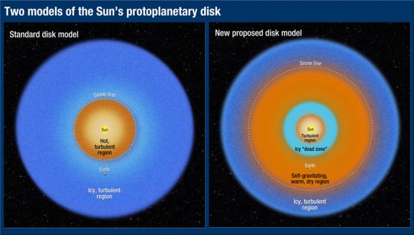

“Astrophysicists have known for quite a while that disks around young stellar objects are NOT standard accretion disks (namely, ones that are ionized and turbulent throughout),” added Dr. Livio in an email to Universe Today. “Disk models with dead zones have been constructed by many people  for many years. For some reason, however, calculations of the evolution of the snow line largely continued to use the standard disk models.”

Without fully ionized disk, the material is not drawn inward. Instead it orbits the star, condensing gas and dust into a “dead zone”  that blocks outlying material from coming any closer. Gravity compresses the dead zone material, which heats up and dries out any ices that exist immediately outside of it. Based on the team’s research it was in this dry region that Earth formed.

The rest, as they say, is water under the bridge.

The team’s results have been accepted for publication in the journal Monthly Notices of the Royal Astronomical Society.

Read the release on the Hubble news site here, and see the full paper here.

Lead image: Earth as seen by MESSENGER spacecraft before it left for Mercury in 2004. NASA/Johns Hopkins University Applied Physics Laboratory/Carnegie Institution of Washington. Disk model image: NASA, ESA, and A. Feild (STScI). Earth water volume image:  Howard Perlman, USGS; globe illustration by Jack Cook, Woods Hole Oceanographic Institution (©); Adam Nieman.

Water Balloons in Space

As part of his ongoing (and always entertaining) “Science Off the Sphere” series, Expedition 31 flight engineer Don Pettit experiments in orbit with a classic bit of summertime fun: water balloons.

Captured in real-time and slow-motion, we get to see how water behaves when suddenly freed from the restraints of an inflated latex balloon… and gravity. With Don NASA doesn’t only get a flight engineer, it gets its very own Mr. Wizard in space — check it out!

Titan’s Tides Suggest a Subsurface Sea

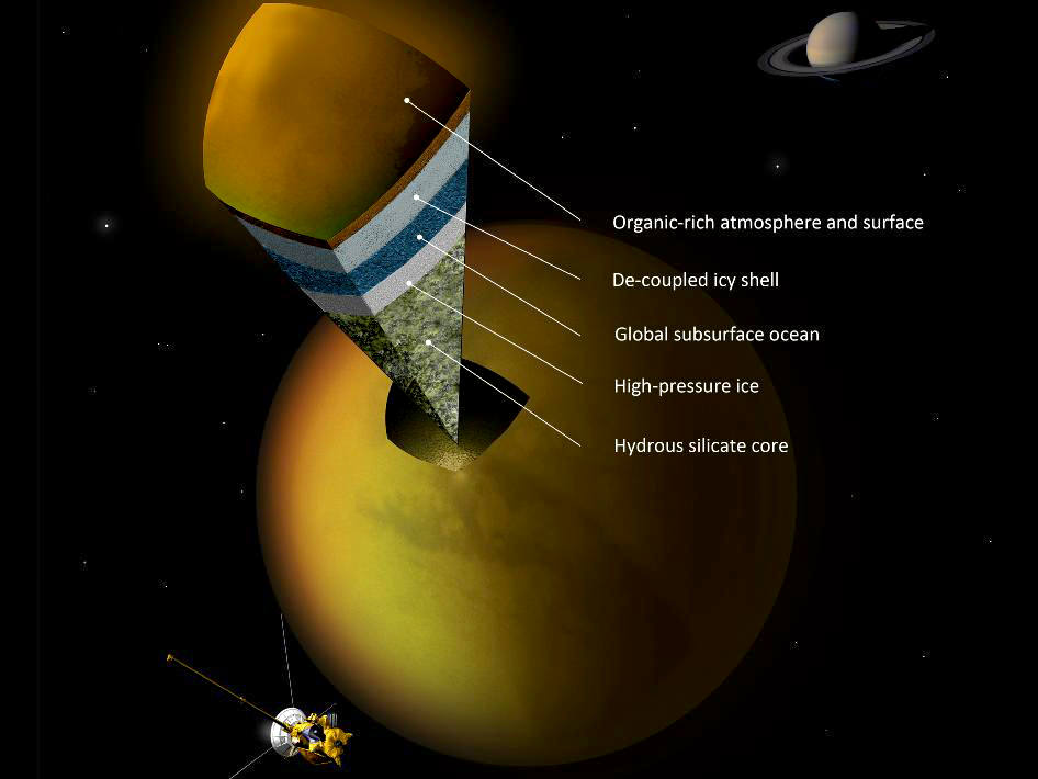
Saturn’s hazy Titan is now on the short list of moons that likely harbor a subsurface ocean of water, based on new findings from NASA’s Cassini spacecraft.

As Titan travels around Saturn during its 16-day elliptical orbits, it gets rhythmically squeezed by the gravitational pull of the giant planet — an effect known as tidal flexing (see video below.) If the moon were mostly composed of rock, the flexing would be in the neighborhood of around 3 feet (1 meter.) But based on measurements taken by the Cassini spacecraft, which has been orbiting Saturn since 2004, Titan exhibits much more intense flexing — ten times more, in fact, as much as 30 feet (10 meters) — indicating that it’s not entirely solid at all.

Instead, Cassini scientists estimate that there’s a moon-wide ocean of liquid water beneath the frozen crust of Titan, possibly sandwiched between layers of ice or rock.

“Short of being able to drill on Titan’s surface, the gravity measurements provide the best data we have of Titan’s internal structure.”

– Sami Asmar, Cassini team member at JPL

“Cassini’s detection of large tides on Titan leads to the almost inescapable conclusion that there is a hidden ocean at depth,” said Luciano Iess, the paper’s lead author and a Cassini team member at the Sapienza University of Rome, Italy. “The search for water is an important goal in solar system exploration, and now we’ve spotted another place where it is abundant.”

Although liquid water is a necessity for the development of life, the presence of it alone does not guarantee that alien organisms are swimming around in a Titanic underground ocean. It’s thought that water must be in contact with rock in order to create the necessary building blocks of life, and as yet it’s not known what situations may exist around Titan’s inner sea. But the presence of such an ocean — possibly containing trace amounts of ammonia — would help explain how methane gets replenished into the moon’s thick atmosphere.

“The presence of a liquid water layer in Titan is important because we want to understand how methane is stored in Titan’s interior and how it may outgas to the surface,” said Jonathan Lunine, a Cassini team member at Cornell University, Ithaca, N.Y. “This is important because everything that is unique about Titan derives from the presence of abundant methane, yet the methane in the atmosphere is unstable and will be destroyed on geologically short timescales.”

The team’s paper appears in today’s edition of the journal Science. Read more on the Cassini mission site here.

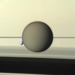
Top image: artist’s concept showing a possible scenario for the internal structure of Titan. (A. Tavani). Side image: An RGB-composite color image of Titan and Dione in front of Saturn’s face and rings, made from Cassini images acquired on May 21, 2011. (NASA/JPL/SSI. Composite by J. Major.)

Mars Has Watery Insides, Just Like Earth

Researchers from the Carnegie Institution have found that water is present in surprisingly Earthlike amounts within Mars’ mantle, based on studies of meteorites that originate from the Red Planet. The findings offer insight as to how Martian water may have once made its way to the planet’s surface, as well as what may lie within other terrestrial worlds.

Earth has water on its surface (obviously) and also within its crust and mantle. The water content of Earth’s upper mantle — the layer just below the crust —  is between 50 and 300 ppm (parts per million). This number corresponds to what the research team has identified within the mantle of Mars, based on studies of two chunks of rock — called shergottites — that were blasted off Mars during an impact event 2.5 million years ago.

“We analyzed two meteorites that had very different processing histories,” said Erik Hauri, the analysis team’s lead investigator from the Carnegie Institute . “One had undergone considerable mixing with other elements during its formation, while the other had not. We analyzed the water content of the mineral apatite and found there was little difference between the two even though the chemistry of trace elements was markedly different. The results suggest that water was incorporated during the formation of Mars and that the planet was able to store water in its interior during the planet’s differentiation.”

The water stored within Mars’ mantle may have made its way to the surface through volcanic activity, the researchers suggest, creating environments that were conducive to the development of life.

Like Earth, Mars may have gotten its water from elements available in the neighborhood of the inner Solar System during its development. Although Earth has retained its surface water while that on Mars got lost or frozen, both planets appear to have about the same relative amounts tucked away inside… and this could also be the case for other rocky worlds.

“Not only does this study explain how Mars got its water, it provides a mechanism for hydrogen storage in all the terrestrial planets at the time of their formation,” said former Carnegie postdoctoral scientist Francis McCubbin, who led the study.

The team’s research is published in the July edition of the journal Geology. Read more on the Carnegie Institution for Science’s site here.

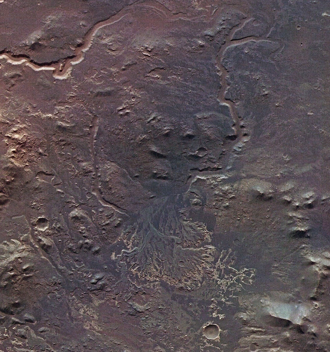
Image: The remains of what appears to be a river delta within Eberswalde crater on Mars, imaged by ESA’s Mars Express. Credit: ESA/DLR/FU Berlin (G. Neukum).

More Evidence of Mars’ Watery Past

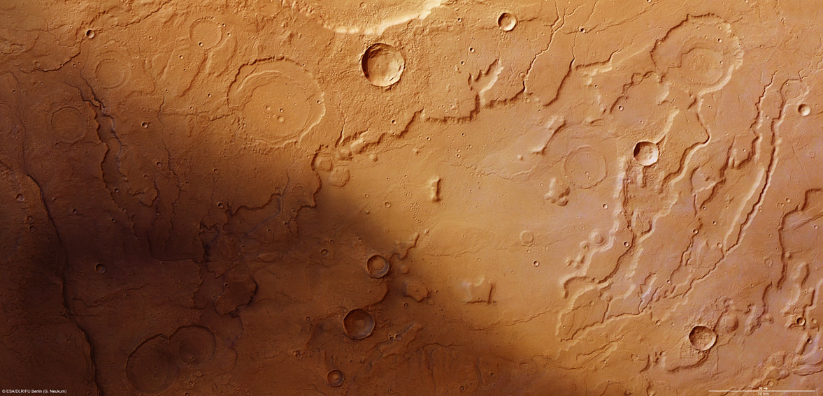
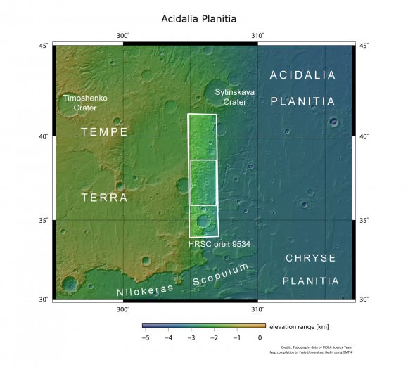
The transition between Acidalia Planitia and Tempe Terra from the Mars Express High-Resolution Stereo Camera (HRSC). Credit ESA/DLR/FU Berlin (G. Neukum)

[/caption]

ESA’s Mars Express orbiter has sent back images revealing terrain that seems to have been sculpted by flowing water, lending further support to the hypothesis that Mars had liquid water on its surface at some point.

The region seen above in a HRSC image is along the border of the Acidalia Planitia region, a vast, dark swath of Mars’ northern hemisphere so large that it’s visible from Earth.

In 1877 the Italian astronomer Giovanni Schiaparelli named the region after a mythical fountain, where the three Graces of Greek mythology were said to have bathed.

Although there may not be any fountains or ancient Immortals within Acidalia Planitia, there may have been water — enough to carve serpentine channels and steep scallops along the edges of wide valleys, much in the same way that the Grand Canyon was carved by the Colorado River.

In the HRSC image some of the etched valleys extend outwards from craters, implying that they were created by water emptying out from within the craters. In addition, sediments present within older craters indicate that they were once filled with water, likely for an extended time.

Acidalia Planitia in a broader context. (NASA MGS MOLA Science Team)

With images like these, so reminiscent of similar features found here on Earth, it’s hard to discount that Mars once had liquid water upon its surface; perhaps some of it still remains today in pockets beneath the ground!

Read more on the ESA site here.

Earth Has Less Water Than You Think

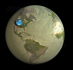
All the water on Earth would fit into a sphere 860 miles (1,385 km) wide. (Jack Cook/WHOI/USGS)

[/caption]

If you were to take all of the water on Earth — all of the fresh water, sea water, ground water, water vapor and water inside our bodies — take all of it and somehow collect it into a single, giant sphere of liquid, how big do you think it would be?

According to the U. S. Geological Survey, it would make a ball 860 miles (1,385 km) in diameter, about as wide edge-to-edge as the distance between Salt Lake City to Topeka, Kansas. That’s it. Take all the water on Earth and you’d have a blue sphere less than a third the size of the Moon.

Feeling a little thirsty?

And this takes into consideration all the Earth’s water… even the stuff humans can’t drink or directly access, like salt water, water vapor in the atmosphere and the water locked up in the ice caps. In fact, if you were to take into consideration only the fresh water on Earth (which is 2.5% of the total) you’d get a much smaller sphere… less than 100 miles (160 km) across.

Even though we think of reservoirs, lakes and rivers when we picture Earth’s fresh water supply, in reality most of it is beneath the surface — up to 2 million cubic miles (8.4 million cubic km) of Earth’s available fresh water is underground. But the vast majority of it — over 7 million cubic miles (29.2 cubic km) is in the ice sheets that cover Antarctica and Greenland.

Of course, the illustration above (made by Jack Cook at the Woods Hole Oceanographic Institution) belies the real size and mass of such a sphere of pure liquid water. The total amount of water contained within would still be quite impressive — over 332.5 million cubic miles (1,386 cubic km)! (A single cubic mile of water equals 1.1 trillion gallons.) Still, people tend to be surprised at the size of such a hypothetical sphere compared with our planet as a whole, especially when they’ve become used to the description of Earth as a “watery world”.

Makes one a little less apt to take it for granted.

Read more on the USGS site here, and check out some facts on reducing your water usage here.

Water, water, every where,
And all the boards did shrink;
Water, water, every where,
Nor any drop to drink.
– from The Rime of the Ancient Mariner, Samuel Taylor Coleridge

Enceladus On Display In Newest Images From Cassini

Enceladus' southern ice geysers are brilliant in backlit sunlight (NASA/JPL/SSI/J. Major)

[/caption]

The latest images are in from Saturn’s very own personal paparazzi, NASA’s Cassini spacecraft, fresh from its early morning flyby of the ice-spewing moon Enceladus. And, being its last closeup for the next three years, the little moon didn’t disappoint!

The image above is a composite I made from two raw images (this one and this one) assembled to show Enceladus in its crescent-lit entirety with jets in full force. The images were rotated to orient the moon’s southern pole — where the jets originate — toward the bottom.

Cassini was between 72,090 miles (116,000 km) and 90,000 miles (140,000 km) from Enceladus when these images were acquired.

This morning’s E-19 flyby completed a trio of recent close passes by Cassini of the 318-mile (511-km) -wide moon, bringing the spacecraft as low as 46 miles (74 km) above its frozen surface. The goal of the maneuver was to gather data about Enceladus’ internal mass — particularly in the region around its southern pole, where a reservoir of liquid water is thought to reside — and also to look for “hot spots” on its surface that would give more information about its overall energy distribution.

Cassini had previously discovered that Enceladus radiates a surprising amount of heat from its surface, mostly along the “tiger stripe” features — long, deep furrows (sulcae) that gouge its southern hemisphere, they are the source of the water-ice geysers.

Cassini also used the flyby opportunity to study Enceladus’ gravitational field.

By imaging the moon with backlit lighting from the Sun the highly-reflective ice particles in the jets become visible. More direct lighting reduces the jets’ visibility in images, which must be exposed for the natural light of the scene or risk “blowing out” due to Enceladus’ natural high reflectivity.

The images below are raw spacecraft downloads right from the Cassini’s imaging headquarters in Boulder, CO.

Enceladus' geysers in action on May 2, 2012. (NASA/JPL/SSI)
Enceladus sprays ice into the hazy E ring, which orbits Saturn (NASA/JPL/SSI)

Cassini also swung closely by Dione during this morning’s flyby but the images from that encounter aren’t available yet. Stay tuned to Universe Today for more postcards from Saturn!

As always, you can follow along with the ongoing Cassini mission on JPL’s dedicated site here, as well as on the Cassini Imaging Central Laboratory for Operations (CICLOPS) site.

Playing With Water… in Space!

Expedition 30 astronaut and chemical engineer Don Pettit continues his ongoing “Science off the Sphere” series with this latest installment, in which he demonstrates some of the peculiar behaviors of thin sheets of water in microgravity. Check it out — you might be surprised how water behaves when freed from the bounds of gravity (and put under the command of a cosmic chemist!)

See more Science off the Sphere episodes here.

Were Martian Rocks Weathered by Water?

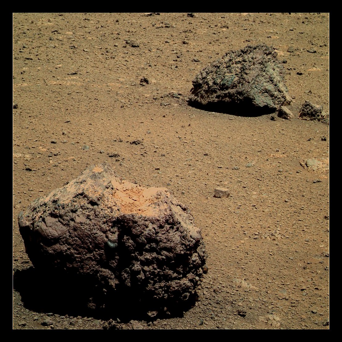
Pitted rocks imaged by Opportunity. NASA/JPL-Caltech/Stu Atkinson.

[/caption]

There are many ways rocks can be textured. Wind erosion, water erosion, the escape of volcanic gases during their formation (in the case of igneous rocks)… all these forces can create the pitted textures found on many rocks on Earth… and perhaps even on Mars. And according to a report published by a group of planetary geologists led by James Head of Rhode Island’s Brown University, another method may also be at play on Mars: melting snow.

Here on Earth in the hyper-arid dry valleys of Antarctica, water from melting snow erodes the surfaces of dark boulders, creating pitted textures similar to what has been found at many locations on Mars.

In order for that process to be truly analogous, though, a few conditions would have to be met on the red planet. First, the atmospheric pressure must be high enough to allow water to remain – if only temporarily – in a liquid state. Water that instantly boils away won’t have enough time to chemically attack the rock. Second, the rock itself must be at least warm enough to not freeze the water (again, must be liquid.) And third, there must actually be water, snow or frost present.

While one or more of these factors may be currently present in locations on Mars, they have not yet been found to exist all together in the same place. But that’s just what’s been found now… in Mars’ geologic past these may all have very well existed either in isolated locations or perhaps even planet-wide.

The paper’s abstract states:

For example, increases in atmospheric water vapor content (due, for example, to the loss of the south perennial polar CO2 cap) could favor the deposition of snow, which if collected on rocks heated to above the melting temperature during favorable conditions (e.g., perihelion), could cause melting and the type of locally enhanced chemical weathering that can cause pits.

In other words, if the dry ice at Mars’ south pole had melted at one point, freed-up water vapor could have fallen on rocks elsewhere as snow. If Mars were at a point in its orbit closest to the Sun and therefore experiencing warmer temperatures the snow could have then melted – especially upon darker rock surfaces.

Still, it’s possible – or even probable – that the weathering did not occur at a consistent rate across the entire surface of the rocks. Some sides may have weathered faster or slower than others, depending on how they were exposed to the elements. But if there’s one thing Mars has had a surplus of, it’s time. Even if the processes outlined in the report are indeed the cause of Mars’ pitted rocks, they have likely been in play over many hundreds of millions – even billions – of years.

Read the team’s report on the Journal of Geophysical Research here.

Thanks to Stu Atkinson for his color work on the images from Opportunity. Check out his blog The Road to Endeavour for updates on the rover’s progress.

Got Drought? Just Tow in an Iceberg

The Sydney iceberg, an April Fools' joke.

[/caption]

As an April Fool’s joke in 1978, Australian businessman Dick Smith claimed he was towing an iceberg from Antarctica to Sydney Harbour. He used a barge covered with white plastic and fire extinguisher foam in effort to convince those who gathered at the harbor to see it. Apparently, however, the idea is not such a joke after all. A team of engineers from France have studied the concept, did a simulation and found that icebergs floating around in the ocean could be tethered and towed to places that are experiencing a severe drought and water shortages.

The idea originally was conceived in the 1970’s by an graduate student named Georges Mougin, who even received some funds from a Saudi prince to test the idea, but not much came of it.

According to an article on PhysOrg, the French engineers looked into the idea and concluded that towing an iceberg from, for example, the waters around Newfoundland to the Canary Islands off the northwest coast of Africa, could be done, and would take just under five months when towed by a tugboat outfitted with a kite sail, traveling at about one knot.

The cost would be almost ten million dollars, however.

According to a simulated test, the iceberg would lose only 38 percent of its seven ton mass during the trip, if it was fitted with an insulated skirt.

Apparently Mougin is encouraged by the results and now at age 86 is trying to raise money for an actual iceberg-tow.

Read more details on PhysOrg.